
❄️🌨️🏝️ #LaPalma island has also received it's dose of snow, mainly around the Taburiente crater.
#Filomena
[THREAD to come later] ⬇️
#Filomena
[THREAD to come later] ⬇️


So let's talk about remote sensing. How does that work? On-board the satellite, there could be several instruments, each one dedicated to measure specific aspects of the planet.
🛰️For Sentinel-2, there is only one instrument, the MultiSpectral Instrument (MSI).
🔗 sentinel.esa.int/web/sentinel/t…
🔗 sentinel.esa.int/web/sentinel/t…
Measurements are made at different bands of wavelengths, referred to as spectral bands.
Sentinel-2 MSI acquires 13 spectral bands.
To understand what is a spectral band, if you've seen the movie "The Predador II", you might remember the scene in the slaugherhouse: ...
Sentinel-2 MSI acquires 13 spectral bands.
To understand what is a spectral band, if you've seen the movie "The Predador II", you might remember the scene in the slaugherhouse: ...

the predator default vision in thermal (infrared), but with the cold there he/she cannot see the preys, so he/she switches to another spectral band: ultraviolet, to see their lights (they are pretty f***)
🎞️
🎞️

The spatial resolution could be defined as the measure of the smallest object that can be resolved by the sensor
It depends on the spectral band we consider. For example, the band no. 8 has a resolution of 10 meters. Nice.
It depends on the spectral band we consider. For example, the band no. 8 has a resolution of 10 meters. Nice.
With this resolution one should be able to see a house, but probably not a car, or a person. Like, I you remember the series "24" (Jack Bauer), they sometimes use satellite to follow a car or a person in real time... well, not possible with Sentinel-2 (as far as I know).

Look at this: the Counter Terrorist Unit are really badass!

🌈 Why do they use different bands? Because different wavelengths are absorbed differently by the atmosphere or the ocean.
Combining them allows to create other "products", for example the Moisture Index, which combines the bands 8A and 11.

Or the NDSI (normalized difference snow index), obtained from the bands 3⃣ and 1⃣1⃣. The snow from the 1st image of the thread is seen in blue, but also areas not covered by snow are blue. Nothing is perfect.

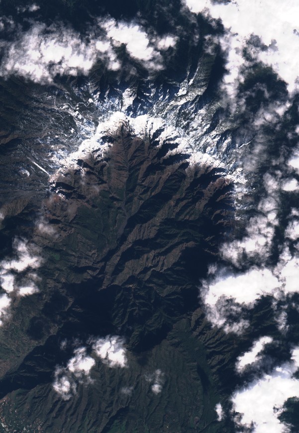
To finish the thread, I have to say a words about the clouds... they are not too friendly in this case, because most of the satellites cannot see through them.
Like this image on January 3rd, also over La Palma.
Like this image on January 3rd, also over La Palma.

So some scientists have developed techniques to get rid of those clouds. You can check @aida_alvera tweet to see example of that.
Last one for today, another picture (without snow) of the Caldera de Taburiente.

Hey @threadreaderapp, could you unroll that for me?
• • •
Missing some Tweet in this thread? You can try to
force a refresh


