
In advance of tomorrow's official release of my book Paper Trails, today I'm releasing US Post Offices - the underlying spatial-historical dataset that made the book possible. Here's a peek into the data:
US Post Offices contains records for 166,140 post offices that operated in the US between 1639-2000. It is one of the most detailed and expansive datasets available for studying US historical geography on a year-by-year basis.
I'll be posting more in the coming days and weeks about some of the patterns and findings this dataset reveals. But I wanted to start with a thread about how the data was created and where to find it.
Richard W. Helbock, a postal historian and philatelist, published United States Post Offices, an 8-volume series aimed at fellow stamp collectors as “the first attempt to publish a complete listing of all the United States post offices which have ever operated in the nation.”
I discovered Helbock's work in 2013, two years after he passed away. Thankfully, Catherine Clark was still selling her late husband's work online and I was able to purchase a CD-ROM of the data. Without Helbock or Clark, none of this would have been possible 🙏
Helbock completed years and years of archival research to collect data from sources like microfilmed departmental records. Despite never having met him, I wanted to credit this labor. So I have included him posthumously as the co-creator of this dataset. 
My part in this was to process Helbock's data and develop a way to geocode these records (locate them on a map). I settled on using the Geographic Names Information System (GNIS) as a historical gazetteer: usgs.gov/core-science-s…
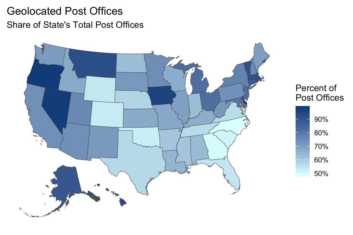
The geocoding process found location coordinates for 2/3 of Helbock's post offices. However, the success rate wasn't evenly distributed. In what could characterize much of American history, results varied from state to state. Ex. 98% of post offices in OR vs. 49% in NC.
A map with 1/3 of its data missing can be misleading. So I also made an alternative version of the dataset that randomly distributed those missing post offices within the surrounding county in which they operated. Here's a comparison of the two versions for CO in 1880:
Even with these limitations, US Post Offices has a lot of advantages. Compared to census data, US Post Offices shows patterns at a sub-county level and for years that don't only end in zero. Ex. Look at the year-by-year shifts in CO in the decade leading up to 1880:
You can also combine US Post Offices with other spatial data, such as a set of shapefiles of Native land cessions and government reservations from @claudiosaunt et. al's invasionofamerica.ehistory.org
Pairing this data casts postal expansion in a different light. In CO, the 1873 Brunot Agreement seized 3.7 million acres of Ute land (light gray on the map), but the US Post's ability to expand into a remote mountainous area helped settlers rapidly occupy this plundered land.
In fact, as I argue in both Paper Trails and the accompanying website gossamernetwork.com, the US Post facilitated a wider process of settler colonial expansion & Indigenous dispossession during the 19th century:
As of today, US Post Offices is now available for anyone to download. First, if you're planning to use it please start by reading the data biography (h/t @datassist): cblevins.github.io/us-post-office…
Second, I decided to use @HarvardDV as the primary archival repository for the dataset itself. This gives it a stable institutional home and permanent DOI for long-term access and citation: doi.org/10.7910/DVN/NU….
Third, @github is still the standard for sharing code. I made a Github repository to share the R code I wrote to process and geocode Helbock's data: github.com/cblevins/us-po…
Finally, US Post Offices made up the analytical backbone of Paper Trails: The US Post and the Making of the American West and its companion website gossamernetwork.com. Order the book today if you want to read more - and use AAFLYG6 to get 30% off! :) global.oup.com/academic/produ…

• • •
Missing some Tweet in this thread? You can try to
force a refresh


