
1. People are dropping Robert Moses on this tweet like he's the only racist road builder out there. I'd say Mayor Pete underselling when he says "SOME of our highways." Moses may have been the LeBron of racist infastructure, but he was not the only player.
Here's a little 🧵.
Here's a little 🧵.
https://twitter.com/yaf/status/1380672884457213954
2. First, be aware that the Eisenhower Interstate System had ulterior motives built into it. Yeah, it was great for moving commercial goods from Tucson to Tucumcari. Of course it made it easier for us to See the USA in our Chevrolets, but it also it was great for moving rockets.
The minimum bridge height for clearing Interstates is 16' (4.9 m), not only for the road, but for both shoulders, and a little more. Because a missile on a trailer's height is about 14'. The interstate gave the military a very easy way to move munitions where they wanted.
4. The interstate system was also designed to have a large percentage of straight, level, overpass-free stretches of road that were 2 miles long or more, which could be quickly and easily converted into ersatz landing strips, in case Air Force bases were destroyed.
5. This was typical Cold War thinking. Everything--absolutely everything that the US did--had potential military applications built right into it. It was just part of the American Way of Thinking.
Another part of that American Way of Thinking was racism. Blatant, codified racism.
Another part of that American Way of Thinking was racism. Blatant, codified racism.
6. The most obvious example of this is Redlining, where Black & poor neighborhoods were highlighted on maps by literally drawing red lines around them. And the rules about what could be done in those neighborhoods were different than what could be done outside of them.
7. The most obvious difference, of course, was that you could destroy them. In the name of progress, of course. When the Eisenhower Interstate System went through cities, these were the neighborhoods where the pavement went.
Unless it had already been usurped for manufacturing.
Unless it had already been usurped for manufacturing.
And once the Interstate (or its 3-digit spurs) connected the cities to the country, people could now live in the country and still work in the city, because there was a 2, 3, or 4 lane chute that got you there in. your car.
All you needed was money, and a reason.
All you needed was money, and a reason.
And often, the reason was "schools," which was a much nicer way of saying "racism." (I lost a whole bunch of friends on Facebook making this argument a few years ago).
At the same time as the Interstate roads were being built, civil rights issues were being raised.
At the same time as the Interstate roads were being built, civil rights issues were being raised.
10. MLK, Malcom X, Rosa Parks, Woolworth Lunch Counter, Black Panthers...the news was full of stories about Blacks were demanding the same rights as whites.
But unless you were in specific locations, much of this activity stayed in your newspaper or with Walter Cronkite.
But unless you were in specific locations, much of this activity stayed in your newspaper or with Walter Cronkite.
11. There was ONE ruling that hit everyone everywhere equally hard, tho: Brown v Board of Education of Topeka, KS., the landmark ruling that made racial segregation in public schools unconstitutional, argued in 1954 by future SCOTUS Justice Thurgood Marshall.
12. This meant that all of the schools in these cities where there were white neighborhoods right up against Black neighborhoods had to allow both to go to the same schools...at the exact same time that you could easily move to the suburbs if you had enough money.
13. Thus began White Flight. And that happened everywhere. Which meant there needed to be more highways to get the white folks away from the Black folks. Which would destroy more Black neighborhoods.
Here's an interesting story from where I live, Rochester, NY:
Here's an interesting story from where I live, Rochester, NY:
14, There are 3 main highways in Rochester: 390, 490, and 590, all named due to their proximity to I-90 aka the NYS Thruway, which runs a dozen miles or so south of Rochester. 390 serves the west side, 590 the east, and 490 arcs through downtown, intersecting both. 
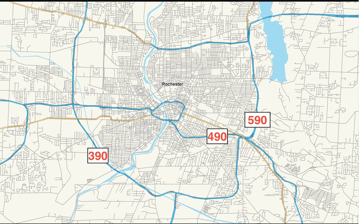
15. You'll notice that where 490 & 390 intersect it's pretty straightforward, because that happened well outside the city limits, in a town called Chili (pronounced "CHAI-lie" because Rochester is weird), that had plenty of empty space.
But that space where 490 & 590 collide?
But that space where 490 & 590 collide?

16. Well, that's a whole 'nuther Can of Worms.
Which is what it was called.
Well, OFFICIALLY it was the 490/590 Interchange or something dull like that.
But for every other damn person who had a car, it was THE CAN OF WORMS! (dun-dunn-dunn-DAAAAAAH)
And it was hell.
Which is what it was called.
Well, OFFICIALLY it was the 490/590 Interchange or something dull like that.
But for every other damn person who had a car, it was THE CAN OF WORMS! (dun-dunn-dunn-DAAAAAAH)
And it was hell.


17. In a very short space you had four lanes intersect, and if you were trying to get from 490 to 590 or vice-versa, you had a lot of maneuvering to do, along with a whole bunch of other cars with similar needs. It was an unholy mess.
So why didn't they use more land, you ask?
So why didn't they use more land, you ask?
(Here's where we get to the point, finally)
<ahem>
BECAUSE THERE WERE NO BLACK NEIGHBORHOODS IN THE AREA TO DESTROY.
That interchange had to happen in the town of Brighton, where a whole bunch of white people with money lived and they didn't want their neighborhoods destroyed.
<ahem>
BECAUSE THERE WERE NO BLACK NEIGHBORHOODS IN THE AREA TO DESTROY.
That interchange had to happen in the town of Brighton, where a whole bunch of white people with money lived and they didn't want their neighborhoods destroyed.
19. So there was only a tiny sliver of land available to make this interchange (which, as you remember, helped white people escape black people because schools), thus forcing the project engineer to play accordion with highways.
20. Someone asked the guy if he was gonna have a ribbon-cutting ceremony for the interchange.
"No," he said. "I'm going to take down the barricades and then hide."
It took a couple more decades to design a kinder, gentler path for the white flight, & the Can of Worms is no more.
"No," he said. "I'm going to take down the barricades and then hide."
It took a couple more decades to design a kinder, gentler path for the white flight, & the Can of Worms is no more.
21. Not that it really matters anymore. All of the multinational corporations that used to be downtown (Kodak, Bausch & Lomb, Xerox) have either left or imploded, so we're stuck with some of the worst poverty in America literally right next door to some of the highest incomes.
22. And I mean literally. There are 2 neighborhoods here, right next to each other, that have the highest average-income disparity of any adjoining neighborhoods in the country. We have some of the highest-rated schools in the USA a bike ride away from the absolute worst ones.
23. And I haven't even touched on the Inner Loop and the damage that thing did.
Quick trivia: Did you know that it's called the Inner Loop because there was supposed to be an Outer Loop?
There was. There have even been maps made that include that label.
Quick trivia: Did you know that it's called the Inner Loop because there was supposed to be an Outer Loop?
There was. There have even been maps made that include that label.
24. Let's go back to the map. See that yellow road up there marked "Ridge Rd?" See how it turns from blue highway to yellow surface road at the river? It was supposed to be highway all the way to 390.
Can you guess why it was never completed?
(refer to tweet #18 for a hint)
Can you guess why it was never completed?
(refer to tweet #18 for a hint)

25. That's right. There was no black neighborhood to destroy.
So when @PeteButtigieg says racism was built into "some" highways?
He's being really fucking generous. /end
So when @PeteButtigieg says racism was built into "some" highways?
He's being really fucking generous. /end
• • •
Missing some Tweet in this thread? You can try to
force a refresh


