Geography of Kenya Profile picture
Apr 14, 2021 6 tweets 3 min read Read on X
The poor quality of air in Nairobi is a matter that needs urgent action by policy makers in Kenya.

These two photos show the exact same view before and after the rains. The dense layer of smog over the eastern side of the city blocks out the view of Mt. Kilimambogo.

THREAD.
Nairobi has dangerously high level of toxic particles in the air. As per sensors.africa air quality tracker, Nairobi has particle levels that are 70% higher than the WHO recommended safe levels.

This is a damning statistic for a city that host @UNEP
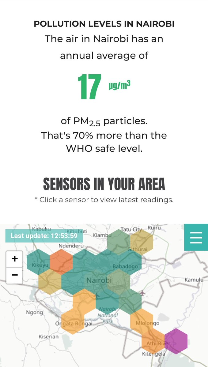
The sensors.africa map shows how air quality decreases in areas with fewer trees and locations close to major highways. These include areas like Mlolongo, Pipeline, Rongai, Kikuyu and Ruiru.

This can be attributed to poor urban planning & unregulated vehicle emissions.
The dangerously high levels of toxic particles in Nairobi (which accounts for most of Kenya's air pollution) can be equated to an invisible pandemic with 19,112 annual deaths and 6,672 child deaths in the country attributed to air pollution.

Covid has killed 2500 in a year.
The strain on the public health system is also evident with increased cases of respiratory infections. Indeed a number of people with chronic respiratory illnesses have noticed reduced incidences of illness since they started wearing masks.
The need to have sustainable urban planning and regulate emissions from public service vehicles has never been more urgent. Relevant government bodies like NEMA, NTSA and the Nairobi County government need to step up to save Nairobi from this unfolding disaster.

End.

• • •

Missing some Tweet in this thread? You can try to force a refresh
 

Keep Current with Geography of Kenya

Geography of Kenya Profile picture

Stay in touch and get notified when new unrolls are available from this author!

Read all threads

This Thread may be Removed Anytime!

PDF

Twitter may remove this content at anytime! Save it as PDF for later use!

Try unrolling a thread yourself!

how to unroll video
  1. Follow @ThreadReaderApp to mention us!

  2. From a Twitter thread mention us with a keyword "unroll"
@threadreaderapp unroll

Practice here first or read more on our help page!

More from @kenyangeography

Dec 20, 2024
Geography of Roads.

Today we feature the Nairobi-Nakuru highway.

The A104 highway straddles the Eastern escarpment of the Rift valley, linking the capital with Nakuru city on the valley floor.

The scenery is stunning all along the route but danger lurks too.

A thread 🧵 Image
Image
Image
The journey starts in Nairobi where the highway heads West towards Gitaru.

Right from the outset, the highway faces an ascent up the highlands of the Rift valley. The elevation starts from Chiromo junction (1700m) to the viewpoint at 'Flyover' junction (2700m), 64km away. Image
Image
Image
Between Westlands and Gitaru, offices and residential units flank the A104 highway. This section is dualled providing for faster mobility.

The elevation rises with the ascent up the highlands. There's a 300m elevation gain along a 30km stretch from Chiromo (1700m) to Gitaru. Image
Read 14 tweets
Apr 29, 2024
Contextualization of the Kijabe mudslide tragedy from a geographic perspective.

🧵
Kijabe escarpment is located between Limuru and Naivasha, the section famously referred to as viewpoint.

The ridge at the top of the escarpment where the Nakuru highway passes has an elevation of 2600m while Mai Mahiu, less than 5km away as the crow flies, is 1900m asp.


Image
Image
Image
Image
The face of the escarpment is steep given the 700m drop over such a short distance. Deep ravines cut across the escarpment face. Surface run off after rainfall drains down to the valley floor via the ravines while a tunnel channels out ground water down the scrap face.


Image
Image
Image
Image
Read 6 tweets
Mar 21, 2022
Ngong river is reportedly the most polluted river in Kenya.

The river flows through informal settlements and Industrial Area where it is polluted by human and industrial waste.

In this thread, we'll trace the river from source to discharge and the various pollution points. ImageImage
Ngong river originates in Motoine forest near Dagoretti. It flows next to the Southern bypass until the Ngong road interchange where it enters the Ngong road forest.

Ngong river then flows within Ngong road forest and enters Kibera in Soweto where the pollution starts. ImageImage
Kibera is actually a bushy river valley where Nubian soldiers were settled by the Brits in colonial times. (Almost all informal settlements in Nairobi are found in riparian zones along river valleys).

Ngong river faces pollution from human waste in Kibera before Nairobi Dam. ImageImage
Read 7 tweets
Dec 21, 2021
December 21 is summer solstice in the Southern Hemisphere. Today is the day when the earth is at its maximum tilt to the south and the Sun’s rays are directly overhead at the Tropic of Capricon.

It might not feel like it but today is the start of 3 months of sunny weather in 🇰🇪
The southern tilt of the earth on its axis exposes the southern hemisphere to more sunlight and causes winter in the less exposed northern hemisphere.

Daylight hours increase further South. Nairobi 1.2°S (12h 12m), Capetown 34°S (14h 25m) and South pole 90°S (24hrs daylight).
After three days at this maximum southern tilt, the earth begins its journey North on December 25.

For the next six months, the earth will slowly tilt North. After three months, we get to Equinox (March 21) & reach the maximum northern tilt on June 21. Then reverse cycle starts.
Read 4 tweets
Apr 21, 2021
Mau forest complex is the biggest closed-canopy forest block in Kenya. It is the source of numerous rivers including Mara river which sustains the Mara-Serengeti ecosystem.

Google Earth's timelapse feature gives a sorry picture of the forest's destruction since 1984.

Thread.
Mau has several forest blocks. The sections to the East, South and South West have suffered the biggest loss of forest cover since 1984.

The first timelapse shows the loss of forest cover in Maasai Mau, largely located in Narok County
The Mau East section in Nakuru county was almost cleared out since 1984, with only the highest sections along the Rift valley escarpment left intact
Read 7 tweets
Apr 19, 2021
Nguruman escarpment is located on the southern-most section of Kenya's western Rift Valley escarpment.

The valley floor (650m) contrasts sharply with the steep scarp walls that peak at 2300m.

Ewaso Nyiro south flows down the scarp towards Lake Natron.

THREAD. Image
Access to Nguruman is via a murram road that passes over Lake Magadi.

The landscape in this southern part of Kenya is one of outstanding Rift valley features. Volcanic mountains (Ollorgesaille, Gelai) reflect on the glassy surface of RV lakes with huge escarpments on the flanks ImageImageImage
A small township is located at the foot of Nguruman escarpment where the landscape changes drastically from parched, dry earth to green, riverine zone.

There's a thriving horticultural community that grows vegetables and some of the sweetest mangoes you'll find anywhere.
Read 4 tweets

Did Thread Reader help you today?

Support us! We are indie developers!


This site is made by just two indie developers on a laptop doing marketing, support and development! Read more about the story.

Become a Premium Member ($3/month or $30/year) and get exclusive features!

Become Premium

Don't want to be a Premium member but still want to support us?

Make a small donation by buying us coffee ($5) or help with server cost ($10)

Donate via Paypal

Or Donate anonymously using crypto!

Ethereum

0xfe58350B80634f60Fa6Dc149a72b4DFbc17D341E copy

Bitcoin

3ATGMxNzCUFzxpMCHL5sWSt4DVtS8UqXpi copy

Thank you for your support!

Follow Us!

:(