Samuel Hughes Profile picture
Apr 20, 2021 5 tweets 3 min read Read on X
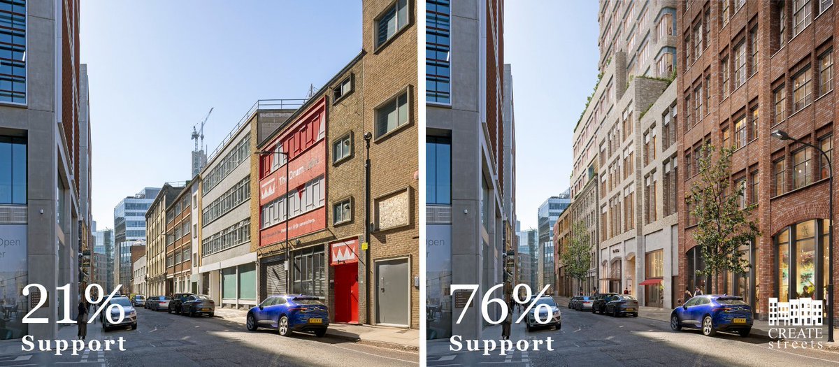
Much controversy at the moment about the plans for a new court complex on Fleet Street. Left is today, right is the proposal.
Two good early 20C buildings and one bad postmodernist one would be lost on Fleet St.
An enormous brutalist building and lovely early Georgian townhouse would be lost on Salisbury Square (these are rather approximate before-and-afters).
Two new public ways through the middle of the block would be opened.
There is plenty of good about this project - this is not a heroes and villains affair. But the cost in terms of architectural heritage does seem very steep.

• • •

Missing some Tweet in this thread? You can try to force a refresh
 

Keep Current with Samuel Hughes

Samuel Hughes Profile picture

Stay in touch and get notified when new unrolls are available from this author!

Read all threads

This Thread may be Removed Anytime!

PDF

Twitter may remove this content at anytime! Save it as PDF for later use!

Try unrolling a thread yourself!

how to unroll video
  1. Follow @ThreadReaderApp to mention us!

  2. From a Twitter thread mention us with a keyword "unroll"
@threadreaderapp unroll

Practice here first or read more on our help page!

More from @SCP_Hughes

Jun 16
Japan is famed for its flourishing urban life, with peerless infrastructure and vibrant urban density. The bewildering image below is Tokyo's rail map, the world's most extensive network, and one of the true wonders of the world.

But it was not always so. Japan entered the twentieth century with large but impoverished cities, whose infrastructure was exceptionally poor. Most of these were then destroyed by war.

Japan developed perhaps the best cities of the modern world in spite of some of the worst starting conditions. An important part of the explanation lies in a policy called ‘land readjustment’.Image
Tokugawa cities obviously did not have trains, trams, buses or cars. More surprisingly, they made little use of wheeled transport, relying on pack animals, canals and porters. This meant they only needed narrow and crooked roads.

The Shogunate divided up commoner areas with walls and gates to monitor and control the movement of the population. They often discouraged the building of bridges for the same reason.

The whole structure of Tokugawa cities was thus antithetical to modern transport needs.Image
Additionally, after the Second World War, the American occupying authorities redistributed Japanese rural land into very small plots, often just one hectare each. This hampered urban expansion, since the smallholders struggled to coordinate to provide infrastructure. Image
Read 10 tweets
Jun 13
In the nineteenth century, railways were the dominant form of mechanised transport. Vast networks were built in many countries. In 1846, the British Parliament mandated 9,500 miles of railways, of which two thirds were ultimately built. By contrast, HS2 will be 140 miles. Image
This was an epoch-defining achievement. But when they reached existing cities, the Victorians faced a key constraint: they did not have the technology to bore tunnels deep under cities, and it was fantastically contentious and expensive to plough through them. Image
This meant that C19 railways tended to terminate on the urban periphery, ultimately forming a network that resembled a ‘wheel without a hub’. Today, cities have expanded far beyond that urban periphery, but the old suburban railways still fail to join together in the middle. Image
Read 8 tweets
Apr 29
In the 1700s and 1800s, English and Irish developers laid out hundreds of garden squares, though there was no planning requirement that they do this, and though they never made any money on them. Why? Image
The reason was that the garden squares raised the value of nearby houses, which were sold by the same developers. They raised it by so much that it outweighed the opportunity cost of not building houses on the squares themselves. Image
This is an example of a general principle in urban economics: if a single landowner develops an entire neighbourhood, they are incentivised to maximise the value of the neighbourhood as a whole, not each plot individually. This often involves devoting land to public goods and curating individual plot uses to ensure they are as neighbourly as possible.Image
Read 15 tweets
Apr 1
London is famous for its garden squares, laid out by private developers in the eighteenth and nineteenth centuries. Why did they do this? A short thread. Image
Image
Image
Most of the expansion of London took place on 'Great Estates', land owned by various church bodies, charities, guilds and aristocratic families. These are some of the survivors today, but originally there were far more. Image
The estates' managers aimed to maximise the value of the estate as a whole, not each individual plot. This meant they would sometimes accept a loss on an individual plot if doing so increased the value of enough of its neighbours. Image
Read 6 tweets
Dec 15, 2024
Remarkably ambitious scheme for Waterloo Station. Waterloo is a vital piece of infrastructure and has some superb Edwardian architecture, but its surroundings are dismal and wayfinding is extraordinarily counterintuitive. Successful remodelling could be a huge improvement. Image
Image
Proposals include a new concourse under the platforms running between new entrances on both sides, the pedestrianisation of Cab Road and Mepham Street, the opening up of viaduct arches for shops and restaurants, and the peninsularisation of the currently appalling 'Imax Plaza'. Image
The work would be partly funded by redeveloping various ugly and badly used sites around the station at higher densities. Image
Read 5 tweets
Oct 18, 2024
From the C18 to the C20, Britain was extremely good at building transport infrastructure. In the Georgian period, 1100 private companies laid out and maintained 22,000 miles of tolled roads (‘turnpikes’), giving Britain the best road network in Europe. Image
Image
Between 1830 and 1900, railway companies built some 20,000 miles of intercity railways, giving Britain the best railway system in the world. (For comparison, HS2 to Birmingham is 143 miles.) Image
The first underground lines were dug in the 1860s, nearly forty years before any others anywhere. The brand name of our first underground line, the ‘Metropolitan’, became the generic noun ‘metro’ in countless languages. Image
Read 21 tweets

Did Thread Reader help you today?

Support us! We are indie developers!


This site is made by just two indie developers on a laptop doing marketing, support and development! Read more about the story.

Become a Premium Member ($3/month or $30/year) and get exclusive features!

Become Premium

Don't want to be a Premium member but still want to support us?

Make a small donation by buying us coffee ($5) or help with server cost ($10)

Donate via Paypal

Or Donate anonymously using crypto!

Ethereum

0xfe58350B80634f60Fa6Dc149a72b4DFbc17D341E copy

Bitcoin

3ATGMxNzCUFzxpMCHL5sWSt4DVtS8UqXpi copy

Thank you for your support!

Follow Us!

:(