@DrydockDreams has a great post up on the Battle of Coral Sea with models of the ships sunk there.
This thread is going to take a lessor known road in exploring that battle.
Namely, why search plane radio communications sucked in the battle.
1/
This thread is going to take a lessor known road in exploring that battle.
Namely, why search plane radio communications sucked in the battle.
1/
https://twitter.com/DrydockDreams/status/1390678119783165956
When people remember the Battle of Coral Sea. These are the sort of strategic and tactical maps people use to understand the battle.
2/
2/


This map is not one normally used for the Coral Sea, but is absolutely necessary backdrop to it.
These are the active Japanese seaplane search sectors in May 1942.
So...why didn't they both spot USN CV's & pass on data to the Japanese CV's?
3/
These are the active Japanese seaplane search sectors in May 1942.
So...why didn't they both spot USN CV's & pass on data to the Japanese CV's?
3/

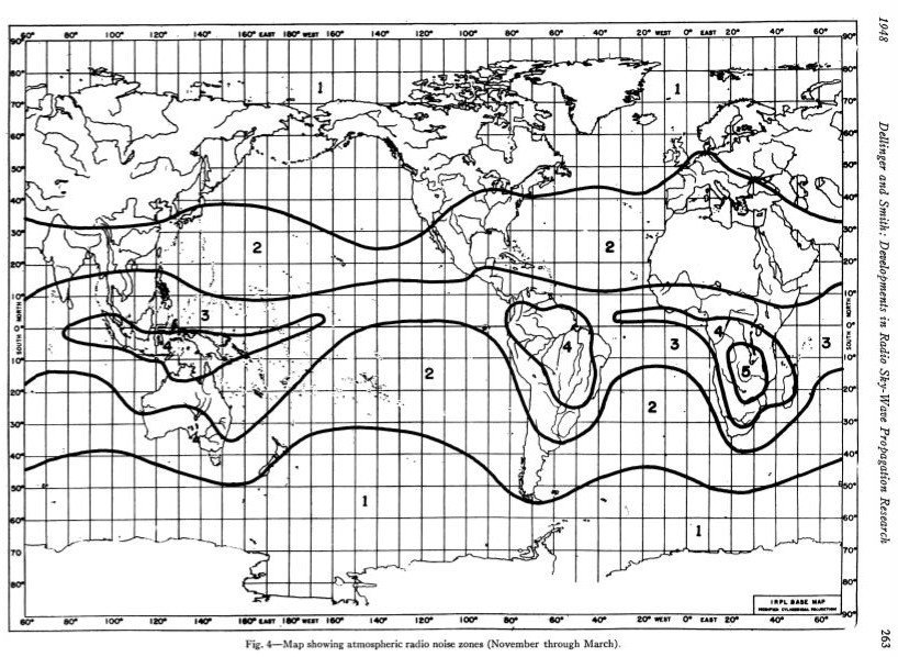
The answer is in this Ionosphere map.
The messages from those IJN seaplane searchers simply could not get through because high frequency radio propagation between them & their bases sucked rocks.
They were in the "Great South Pacific Radio Static Blob."
4/
The messages from those IJN seaplane searchers simply could not get through because high frequency radio propagation between them & their bases sucked rocks.
They were in the "Great South Pacific Radio Static Blob."
4/
And so were the SBD's of the Lexington & Yorktown and IJN cruiser float planes.
5/
5/


High Frequency or "HF" radio was a very hit or miss proposition in May 1942. The "Great South Pacific Radio Static Blob" was completely unknown at the time.
It would be another 3-years before enough science data had been analyzed to construct the ionosphere map up thread.
6/
It would be another 3-years before enough science data had been analyzed to construct the ionosphere map up thread.
6/


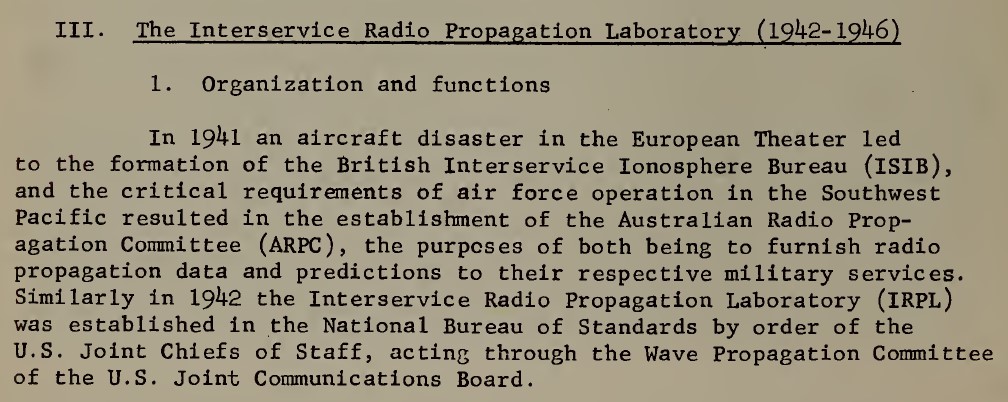
Both the Japanese and the Allies had civil-military scientific organizations involved in monitoring the ionosphere and predicting where the maximum usable frequency (MUF) were day and night.
The origins of the Allied agencies in these screen shots.
7/
The origins of the Allied agencies in these screen shots.
7/

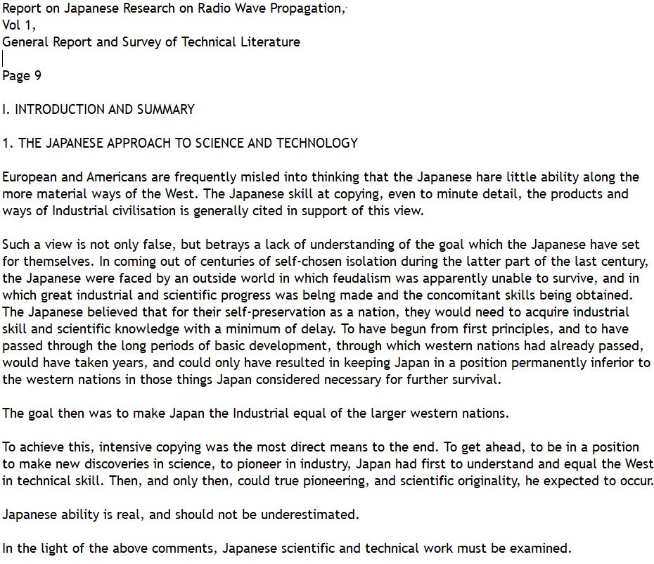
The Japanese had a similar agency, singular, where the Army, Navy & civilian scientists all cooperated in sharing data on a real time basis in a manner seen no where else in the Japanese Empire.
It was called the "Physical Institute for Radio Waves" (Dempa-butsuri Kenkuyo).
8/
It was called the "Physical Institute for Radio Waves" (Dempa-butsuri Kenkuyo).
8/


The US Army Signal Corps was impressed with the Dempa-butsuri Kenkuyo post-war.
But In May 1942 these agencies were -- excepting Australia's Radio Propagation Committee -- too new/far away from the South Pacific to make any difference in the naval battle.
9/
But In May 1942 these agencies were -- excepting Australia's Radio Propagation Committee -- too new/far away from the South Pacific to make any difference in the naval battle.
9/
This lack of H/F radio propagation data was one of the great "What Ifs" of the Battle of Coral Sea.
Better Coordination between the SWPA & USN fleet units was both possible & desirable.
10/
Better Coordination between the SWPA & USN fleet units was both possible & desirable.
10/
This article:
Combat Information Center Magazine
Aug 1944 issue
"farewell to communication failures"
From the Original Manuscript prepared by S/L A. L. Hall, RAAF
See pages 7 thru 11
maritime.org/doc/cic/cic-44…
Details the H/F radio possibilities of May 42.
11/
Combat Information Center Magazine
Aug 1944 issue
"farewell to communication failures"
From the Original Manuscript prepared by S/L A. L. Hall, RAAF
See pages 7 thru 11
maritime.org/doc/cic/cic-44…
Details the H/F radio possibilities of May 42.
11/
As does this report excerpt, undated, but probably written in late 1945:
THE OFFICIAL HISTORY OF THE R.A.A.F.
DIRECTORATE OF TELECOMMUNICATIONS AND RADAR
BY W/CDR, G. F. GATES
IONOSPHERIC ORGANISATION.
groups.google.com/g/rec.aviation…
12/
THE OFFICIAL HISTORY OF THE R.A.A.F.
DIRECTORATE OF TELECOMMUNICATIONS AND RADAR
BY W/CDR, G. F. GATES
IONOSPHERIC ORGANISATION.
groups.google.com/g/rec.aviation…
12/
The Pacific War would be preparing to move move to Leyte in Sept 1944 - after two Allied ionosphere conferences in the UK on 20 Mar 1944 and the 2nd in Wash DC on 10 Apr 1944 - before the Australian H/F radio propagation discoveries/methods were taken into the ISIB & IRPL.
13/
13/
For want of an accurate High Frequency radio propagation prediction at Coral Sea, the USS Lexington was lost.
14/
14/

@threadreaderapp unroll
• • •
Missing some Tweet in this thread? You can try to
force a refresh