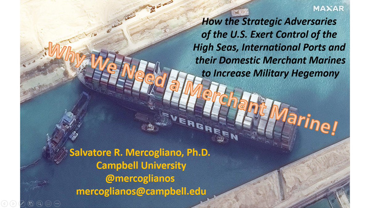
My presentation at the @NDTAHQ Surface Force Projection Conference questioned the need for national merchant marines by examining China and Russia's use of their own to exert hegemony from the past to the present.
The Maritime Silk Road of China's #BeltandRoad Initiative aims to defend their vital trade routes - particularly between Asia & Europe/Africa - and ensure an adequate supply of raw materials and imports to sustain their economy and country.
The historical antecedent may have been the voyages of Zheng He. When the Ming Dynasty assumed power they aimed to ensure the restoration of China as the Middle Kingdom. Their fleet demonstrated the power of China and then was scrapped as trade flowed.
The early 19th century witnessed China's attempt to control its trade & its defeat at the hands of the British and the East India Company. China was forced to concede a 99 year lease of Hong Kong - something that China is doing today along Maritime Silk Road.
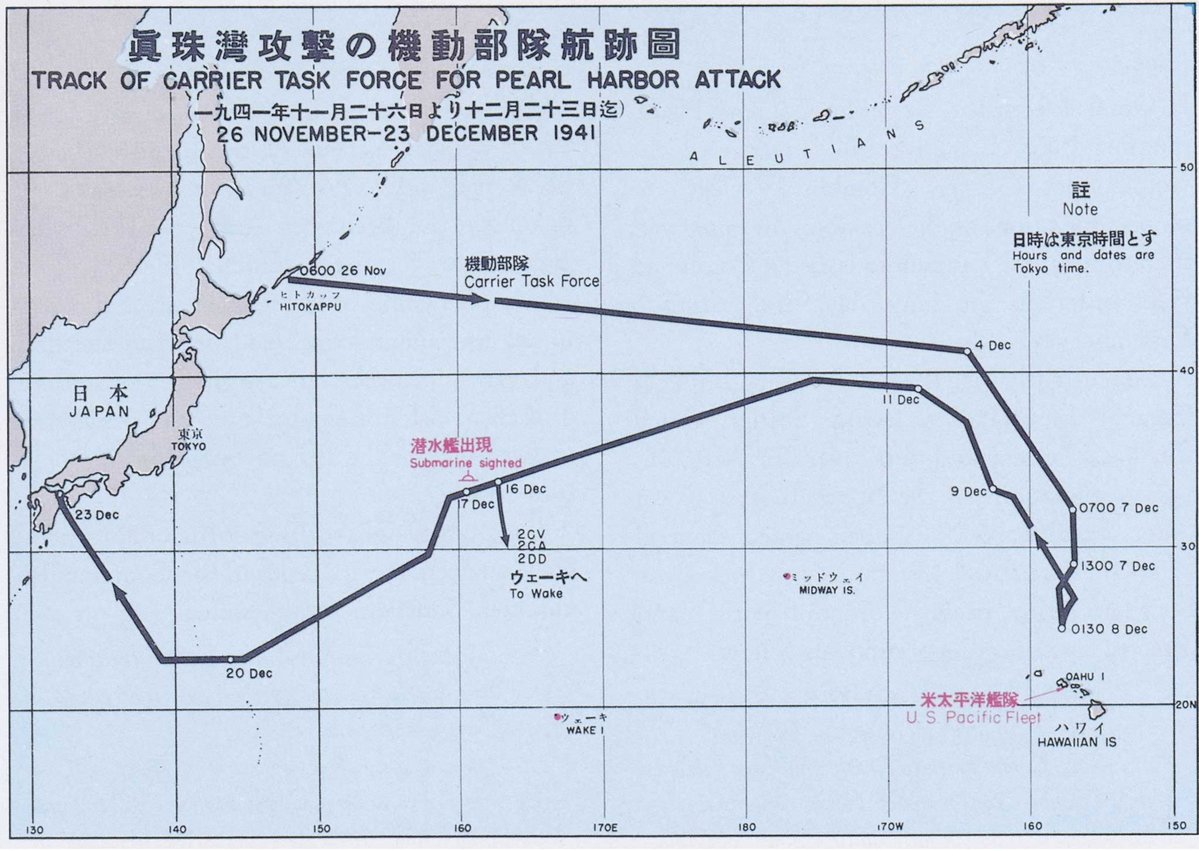
Russia, a continental power, in the early 20th century confronted a new world power that was ridiculed as being inferior. When Russia was denied use of the Suez, its fleet sailed around Africa and was destroyed at Tsushima.

Did the closing of a chokepoint impact its fate?
By the mid-20th century, the Sino-Japanese War saw China being systematically cut off from the outside world by Japan. The US embargo to Japan resulted in war, and this 1937 map discusses a blockade of Japan - a strategy that was emulated in Operation Strangulation.
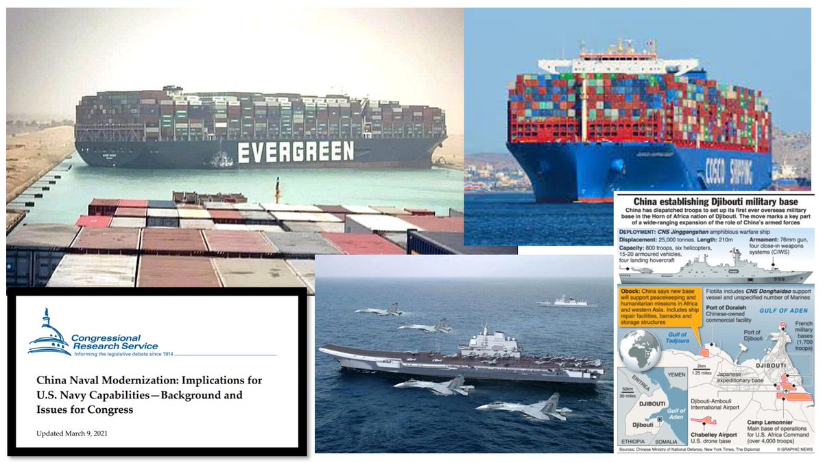
China's COSCO fleet is the largest shipping line in the world, with a well-balanced cargo carrying capacity. Their domestic shipbuilding infrastructure supports the PLAN.

Russia's SOVCOMFLOT is foreign built & specialized in energy from the Arctic, but Russia's navy is lacking.
What if instead of #EverGiven going ashore in Suez, it was COSCO Galaxy in front of her?
Would Egypt be holding her?
How would China react?
The base at Djibouti is strategically placed for such a response. Would this deter Egypt?
Is PLAN geared for peer-to-peer or trade defense?
The Belt & Road has a maritime strategy associated with it. It is expanding into the South Pacific, Arctic, west Africa, and South America. Should one route close, there are alternatives.

The US had a strategy in 1920, but it has waned.

Who is the better Sea Power today?

• • •

Missing some Tweet in this thread? You can try to force a refresh
 

Keep Current with Sal Mercogliano (WGOW Shipping) 🚢⚓🐪🚒🏴‍☠️

Sal Mercogliano (WGOW Shipping) 🚢⚓🐪🚒🏴‍☠️ Profile picture

Stay in touch and get notified when new unrolls are available from this author!

Read all threads

This Thread may be Removed Anytime!

PDF

Twitter may remove this content at anytime! Save it as PDF for later use!

Try unrolling a thread yourself!

how to unroll video
  1. Follow @ThreadReaderApp to mention us!

  2. From a Twitter thread mention us with a keyword "unroll"
@threadreaderapp unroll

Practice here first or read more on our help page!

More from @mercoglianos

Apr 16
1/The @Heritage has released Project 2025 which is entitled Mandate for Leadership: The Conservative Promise. Basically it would be the next Trump administration policy guide. In it is a section on Maritime Policy (p.637-638). Let's take a moment and digest it.
2/A little short on history as MARAD came from the US Shipping Board created in 1916 and then via the US Maritime Commission.

What is also omitted is that MARAD was originally under the Commerce Dept and included @FMC_gov it is purview. Image
3/This statement is 💯% the wrong choice. While they are correct that MARAD does not regulate its industry, it makes no argument to transfer it to @DHSgov.

MARAD should be reorganized into an entity that has oversight of all maritime aspects, akin to the FAA over aviation. Image
Read 11 tweets
Mar 15
1/The latest on the #GazaPier.

A temporary jetty was constructed from concrete and landfill to extend out from the shore.

It was done under the supervision of the IDF.
2/The Spanish-flagged tug Echo 1 Open Arms delivered the barge of 200 tons of food from @WCKitchen via Cyprus.

Due to the shallow draft off the jetty the tug could not push the barge alongside.

This is why the US Army Trident pier will extend approximately 1800 feet out.


Image
Image
Image
3/The barge was maneuvered by the use of two small RHIBs.

This is extremely difficult and danger due to the mass of the barge and the power of the RHIBs. Any current or wind would have precluded this operation.

Image
Image
Image
Read 5 tweets
Mar 8
1/So the winner is the least efficient means possible to move cargo.

1,000 soldiers of @USArmy 7th Transportation Group will construct either an elevated or floating causeway pier.


Image
Image
Image
2/According to the @DeptofDefense spokesperson it will take two weeks to construct.

Okay...but where are the causeways?

They are either in Virginia or onboard prepositioning ships at Diego Garcia or in the western Pacific.

These will need to be shipped and this takes time? Image
3/Also, the throughput of a barge ferry is ridiculously slow. While this may be enough to sustain a few hundred or thousand soldiers in an exercise, the population of Gaza is over 2 million.

This is going to require a lot of cargo to move quickly and efficiently. Image
Read 10 tweets
Mar 8
1/ Why is the concept of a #Gaza #pier not a viable option?

First, Gaza is a flat strip of coast with no protected harbors or coves. Thus means that any 'pier' would be completely open to the elements and seas.

Second, there are two ports just a few miles away.
Image
2/Ashdod in Israel is a large port and could handle the cargo, but it would require transport and delivery through Israeli territory.

Image
Image
Image
3/Al Arish in Egypt is smaller but protected by a breakwater and only a few miles from Gaza and avoids having to traverse Israeli territory.


Image
Image
Image
Image
Read 10 tweets
Jan 31
1/A quick snapshot of all containerships over 16,000 TEUs (or Ultra Large Container Vessels). You can see that they are used exclusively between Europe & Asia as US ports cannot accommodate them, either due to water/air draft or crane capacity.
Image
Image
2/Only a few ports can handle them - Tangier in Africa; Algeciras, Genoa, Piraeus, Istanbul, Port Said & Gioia Tauro in the Med; Hamburg, Bremerhaven, Rotterdam, Antwerp, Felixstowe & Antwerp in Northern Europe & in Asia, multiple ports in China, Singapore, Columbo & Khalifa.
Image
Image
3/Noticeably missing are any US ports - on either the East, Gulf or West Coasts.

The Ultra Large Container Vessels (ULCV) were built to just fit in the Suez, hence 399.99 meters in length.

But now with the diversion caused by the #Houthi, questions arise about the ULCVs. Image
Read 8 tweets
Jan 27
1/MT Marlin Luanda, a 110,000 deadweight ton tanker and owned by a company in the Marshall-Is and flagged in the same, sailed from Greece after loading a cargo of Russian naphtha from tankers via the Black Sea.

The cargo was not sanctioned and sold under the price cap.

Image
Image
Image
2/The ship identified its destination as Singapore but that was probably not its final one.

Over the past year, it has operated over an extensive area, typical of Suezmax/LR2 tanker. Image
3/The ship has a valuation of $61.3M and its cargo of naphtha was probably similar. A value of $120 million would lead to a war risk of approximately $1.2M for the ship if at 1%. Image
Read 11 tweets

Did Thread Reader help you today?

Support us! We are indie developers!


This site is made by just two indie developers on a laptop doing marketing, support and development! Read more about the story.

Become a Premium Member ($3/month or $30/year) and get exclusive features!

Become Premium

Don't want to be a Premium member but still want to support us?

Make a small donation by buying us coffee ($5) or help with server cost ($10)

Donate via Paypal

Or Donate anonymously using crypto!

Ethereum

0xfe58350B80634f60Fa6Dc149a72b4DFbc17D341E copy

Bitcoin

3ATGMxNzCUFzxpMCHL5sWSt4DVtS8UqXpi copy

Thank you for your support!

Follow Us!

:(