A few days ago MH-17 blogger @marcelvandenb19 called MH-17 author @beek38 a "Kremlin"-something, because he asked/doubted if/that the smoke plume reached over the photographer's house. Reason enough to take another look at the matter with some new information and possibilities.
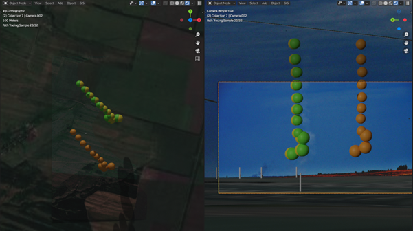
I created a model of the entire area using a geographic information system (GIS) that can directly import Google maps and the elevation profile into a 3D application. At all crucial points, I also compared the elevation data with GoogeEarth. 

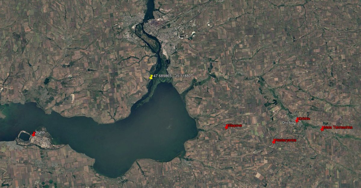
Launch field:

Then I placed the cameras and the photos as a background, so that you can immediately compare between what the photo shows and the conditions required.

The first thing I noticed is that the photographer used a focal length of 180mm according to the metadata. In that 3D program, however, you need a focal length of exactly 280mm to simulate the same image detail.


In addition, I was unaware until the day before yesterday that there was not just one more trail photo, but two more photos.
Here is the story of their discovery, which sounds quite dubious to my ears. But let's not be biased.
Here is the story of their discovery, which sounds quite dubious to my ears. But let's not be biased.
The image quality is habitually abysmal, the photographer is unknown, the image was seen and downloaded by only one person, immediately uploaded again, and only a JIT employee was able to find the image two years later after legions of investigators had been searching for years.

Strangely, @bellingcat has a 2560x1428px version although VK (the alleged origin) downsizes all images to 1280 x 714px. ...artificially blown up? (left). They also show a section of a much higher resolution (right). SuperResolution Plugin? We don't know.

Link to the Bellingcat article: bellingcat.com/news/uk-and-eu…
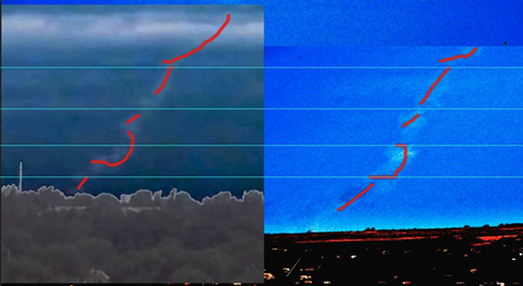
If you superimpose the images, it looks like the camera and clouds are moving. So everything is normal?
...but strangely enough the clouds seem to be moving south and apparently the photographer decided to zoom away from the smoke trail. What photographer would do that?
...but strangely enough the clouds seem to be moving south and apparently the photographer decided to zoom away from the smoke trail. What photographer would do that?
However, the same view was posted two days earlier by a Snizhne-based pro-Kiev activist. Even more, the first new trail picture (let's call it picture 3) appears like a distorted crop of the second new trail picture (let's call it picture 4).


If you eliminate the distortion then nothing moves, no tree, no bird, no cloud. Some details:
Only the smoke plume moves, and it moves like a stick from the ground to the clouds.
The lower part:
The blocks of the poor resolution of photo 4 look a bit like the clouds are moving, but they are not - at least not in the direction the column of smoke is moving.
The question is, though, if the smoke plume disappears into the clouds (since it reaches all the way over the other photographer's house) how can it move while the clouds don't? Shouldn't they both be in the same wind?
Let's consider the position. From the Aleynikov photos, we know that the smoke trail should be moving in a westerly direction. Let's also assume that the origin is one of the discussed launch spots. Then the position of the smoke column according to photo3 would be about here.

According to photo4, the smoke trail then moved either a little to the west (green) or to the southwest (orange). However, since we assume the launch spots in question, we assume that the green direction must be correct.

Apparently, all deformations of the smoke plume were in such a spatial orientation (+/- half angle between the cameras) that they could be seen equally by both cameras.
So you only have to deform the Aleynikov smoke plume obliquely and you get the shape as visible in photo 3.
So you only have to deform the Aleynikov smoke plume obliquely and you get the shape as visible in photo 3.
So let's look at our smoke position from Aleynikov's point of view! Obviously we can exclude orange. Green, on the other hand, is exactly in the position Aleynikov first photographed (cable photo).

That is, photo3 was photographed before Aleynikov took his 1st photo. Photo4, however, must have been taken at about the same moment.
That the smoke plume in photo4 appears wider and diluted, we blame on the poor image quality for now.
That the smoke plume in photo4 appears wider and diluted, we blame on the poor image quality for now.

We now need another smoke plume in the green direction of movement, but in the position of Aleynikov's zoom shot (blue).

So far everything fits fine. We now also know that photo3 and photo4 were photographed within only about 2 seconds, because Aleinikov's 7 second difference requires about 3 times as much displacement.

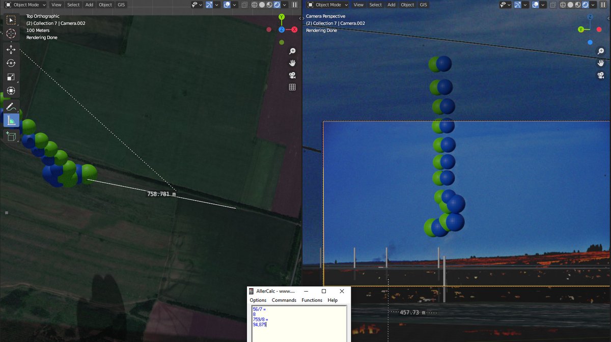
Since we now have the exact positions of the smoke plume - at least if one of the assumed launch spots is correct - we can now determine distances and velocities. So the smoke plume moved 55-56m in 7 seconds. That is about 8m/s from East to West.

Also, the plume is 458m (57 sec) away from the Oliphant spot and 759m (95 sec) away from the alleged BUK tracks. If Aleynikov had heard the explosion of the aircraft (~70 sec after launch) and therefore reached for the camera, he would be too late for Oliphant's launchspot...

...but he would have 15 seconds for the alleged BUK tracks launch spot next to the little tree.
Marcel van den Berg calculated the possibility that he heard the impact of the plane. In that time, however, the plume would have already traveled 1600 meters, plus the time it would have taken the photographer to go to the balcony.

Amazingly, no matter how Marcel van den Berg turns it around, he always comes to a "fitting” result.
whathappenedtoflightmh17.com/analysis-of-th…
But it isn't.
whathappenedtoflightmh17.com/analysis-of-th…
But it isn't.

For this reason, the prosecution has probably recently settled on a different location, which disregards alleged BUK tracks and burning fields. Were these really only phenomena of the harvest time in the end? ...as lots of "conspiracy Putinist" suggested? LMAO

The new starting point is 1010 m (126 sec) away from the photographed smoke columns. That is two minutes in which the smoke moved as a straight column without deforming or dissipating significantly. Nevertheless, all photos were taken within 10 seconds. Really?

Is it possible that the accusation changes until it fits? How about investigating why photo4 looks like a distorted copy of photo3, zooms away instead of zooming in, and whether the column of smoke is actually moving even though the clouds are not?
But maybe I'm wrong.
But maybe I'm wrong.
We will see in a moment that all this back and forth changes nothing at all.
The clock of Aleynikov's camera was allegedly wrong, sometimes 4min, sometimes 1min, but the time intervals between the photos are not affected, right? For a long time, the metadata were a well-kept secret by Bellingcat. Now, thanx Marcel, they are known.


An image from old frustrated times:

However, from these time codes it appears that Aleynikov took the photo DSC_9267.nef 265 seconds after the cable shot. And another 31 seconds later he shot the DSC_9273.nef photo.
It is to Marcel's credit that he obtained the timecodes and performed the calculation I suggested, although he did so to disprove my estimate, I fear. However, the result of his effort was a wind speed of 8.5m/s in the area of the crash site.

To do something with this data, we need some additional information.
JIT estimates that the missile took 32 seconds to fly from the field to the aircraft. They also estimate that the debris took 60-90 seconds to hit the ground.
That's very fast.
JIT estimates that the missile took 32 seconds to fly from the field to the aircraft. They also estimate that the debris took 60-90 seconds to hit the ground.
That's very fast.
By comparison, the president of Aero Consulting Experts says 3-5 minutes and a respected physics journal says 3 minutes. JIT is more than twice as fast for no apparent reason. Or is there a reason? popularmechanics.com/adventure/outd…

If we take all these data together, the photographed smoke column traveled 1270 meters before it was photographed by Aleynikov. This would make the starting point 260 meters further east than the new suggestion of the prosecution.

Well, that's for a 60sec fall time.
If we follow the non-anonymous expert opinion and assume a fall time of 3 minutes, then the smoke column south of Snizhne must have traveled 2230 meters before it was photographed 4 times within 10 seconds and then never again.
If we follow the non-anonymous expert opinion and assume a fall time of 3 minutes, then the smoke column south of Snizhne must have traveled 2230 meters before it was photographed 4 times within 10 seconds and then never again.

There is only one way to solve this Gordian knot, and that is a negative flight time of the missile of -2 minutes, if we assume a fall time of 3 minutes.
!!!
!!!
If we assume JIT's super short 60 sec fall, then the missile has ZERO sec of flight time available. For the Bellingcat launch site near the little tree it is -30 sec and for the Oliphant launch site it is -70 sec.

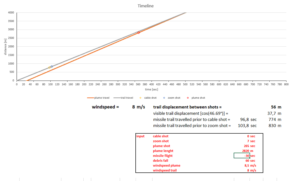

A reasonable explanation for this result would be that the BUK missile was launched from one of these locations after MH-17 had already been hit. Another explanation would be the manipulation of evidence to the limit of nonsense.
So, prove me wrong or start an investigation!
So, prove me wrong or start an investigation!
• • •
Missing some Tweet in this thread? You can try to
force a refresh