
A thread about the new 10m global landcover dataset released by ESRI and Microsoft, a quick look at how it fares for India, and some thoughts on making it better.
livingatlas.arcgis.com/landcover/
livingatlas.arcgis.com/landcover/
2/ Yesterday, @ESRI and @Microsoft, together with @ImpactObserv, released a globally-consistent landcover dataset at 10m resolution, obtained from classifying Sentinel2 imagery.
Foremost, what is fantastic and exemplary is that they released their data under a CC-BY 4.0 license.
Foremost, what is fantastic and exemplary is that they released their data under a CC-BY 4.0 license.

3/ The possibilities of a 10m global landcover dataset are tantalising. And expectations high. Especially, when it describes itself by headlining detail and accuracy.
4/ Yet, the 10-class landcover schema is limiting, particularly given its high spatial resolution.
Further, as a EO dataset in the Anthropocene, that it has so few anthropogenic landcover classes, and that they fall between structural and semantic categories, is worth a think.
Further, as a EO dataset in the Anthropocene, that it has so few anthropogenic landcover classes, and that they fall between structural and semantic categories, is worth a think.
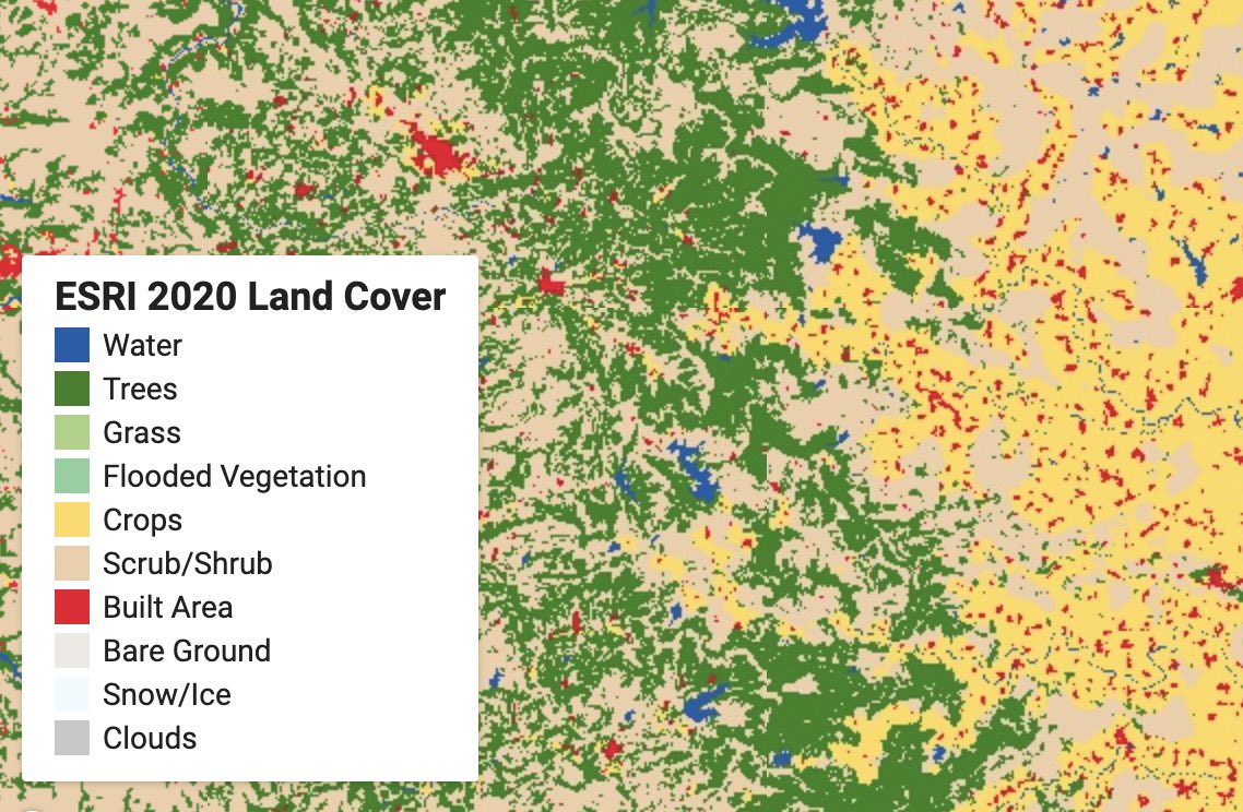
5/ Here are a few examples of how the dataset fares with different landcover contexts in India.
Below is a landscape of tea-estates from south India, which extend over hundreds of sq. km, classified variously as scrub, grass, trees and crops.
Below is a landscape of tea-estates from south India, which extend over hundreds of sq. km, classified variously as scrub, grass, trees and crops.
6/ This problem persists even with tea estates in a completely different ecological/geographic setting from Northeast India.
7/ Even in open, semi-arid settings, the dataset struggles, classifying scrub as crops, and rain-fed cultivation as scrub.
8/ It is particularly troubling that landcover types—like this solar farm, which is among India’s largest—extending over thousands of hectares are not even assigned to a ‘built-up’ category, but rather show up as crops!
(noticed similar problems even in CA’s Central Valley)
(noticed similar problems even in CA’s Central Valley)
9/ This is particularly puzzling, given that such solar farms stand out—both structurally and spectrally—in the input Sentinel 2 imagery.
10/ An exciting area of application for high-resolution data is in understanding landcover within cities. Here too, it was disappointing to see the Indian Institute of Science, one of Bengaluru’s most important green spaces, disappear in a smear of red built-up area.
11/ A few key takeaways:
one, the appropriateness and adequacy of its 10-class schema used to describe landcover in today's human-dominated world needs a serious rethink. What is the value of a 10m landcover map that cannot capture a grassland being turned into a solar farm?
one, the appropriateness and adequacy of its 10-class schema used to describe landcover in today's human-dominated world needs a serious rethink. What is the value of a 10m landcover map that cannot capture a grassland being turned into a solar farm?
12/
two, the accuracy of its classification, even within its own schema—particularly in heterogeneous and dynamic environments—is unfortunately, rather poor. The current level of class generalisation is so heavy-handed as to limit its value in future change-detection work.
two, the accuracy of its classification, even within its own schema—particularly in heterogeneous and dynamic environments—is unfortunately, rather poor. The current level of class generalisation is so heavy-handed as to limit its value in future change-detection work.
13/
three, every large landcover mapping effort is a difficult trade-off between accuracy and generalisability, and inevitably beset with uncertainties. So, rather than having ‘hard’ classes, why not present class probabilities, alongside class designations?
three, every large landcover mapping effort is a difficult trade-off between accuracy and generalisability, and inevitably beset with uncertainties. So, rather than having ‘hard’ classes, why not present class probabilities, alongside class designations?
14/
four, these commissions/ omissions are not inconsequential. I worry that its inadequacies and errors, neither of which are trivial, will propagate rapidly through scientific literature and onward into decision-making, as the dataset gets more and more widely used.
four, these commissions/ omissions are not inconsequential. I worry that its inadequacies and errors, neither of which are trivial, will propagate rapidly through scientific literature and onward into decision-making, as the dataset gets more and more widely used.
15/
Maps are not merely technical products of technological choices. Because they’re representations of reality, they’re unavoidably political. This is where institutional choices of a map-making exercise—of whom to include, and whom to leave out of the process—matter greatly.
Maps are not merely technical products of technological choices. Because they’re representations of reality, they’re unavoidably political. This is where institutional choices of a map-making exercise—of whom to include, and whom to leave out of the process—matter greatly.
16/
Therefore, I do very much hope that this creditable first effort also demonstrates a readiness to incorporate feedback and iterate, both over its technical and institutional choices, to become the wonderful resource it has the potential to be!
Therefore, I do very much hope that this creditable first effort also demonstrates a readiness to incorporate feedback and iterate, both over its technical and institutional choices, to become the wonderful resource it has the potential to be!
• • •
Missing some Tweet in this thread? You can try to
force a refresh


