Urg. Publishers have done it again. After using Czech soldiers in 1945 Belgium to illustrate D-Day, they've now illustrated the 1942 British/Canadian Dieppe Raid with... US soldiers landing from USN LCVPs in 1944.
I'm pretty sure I don't need to explain Operation Jubilee, but just in case, it wasn't a US operation, a only a few Rangers and aircraft were present. Equally, the version of the Higgins Boat LCVP that we are all most familiar with had not yet come into service. 📷@WWIImuseum
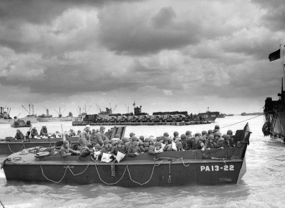
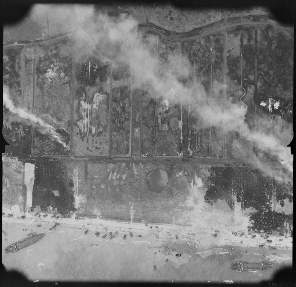
Here's the actual picture. It's easy enough to find online, and naturally is often used to illustrate D-Day. In fact the LCVP is from USS Cepheus (AKA-18), which only ever served in the Mediterranean and Pacific theatres. The background discounts Normandy anyway.
From the uniforms and hills, the Med seems the most likely bet, and most captions describe it as training on the North African coast for Operation Dragoon.
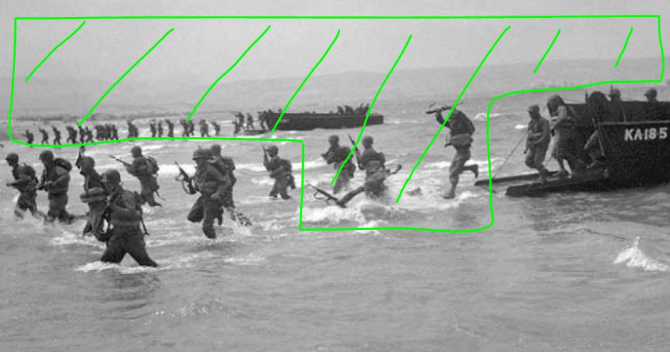
Looking more closely at the image reveals an interesting detail. Evidently the image of someone falling in the surf isn't heroic enough for a book cover, so Photoshop has been liberally used to remove a few men, as well as the entire background.
Surely someone working this closely with the image would have spotted that these are US infantry? Unless of course they had no knowledge of the subject matter and hadn't read the book? And therein probably lies the problem...
Publisher's bonkers insistence that they know better on titles and cover images is putting profit over accuracy, and is ultimately damaging to history. The frustrating belief that any old picture of a landing craft can illustrate an amphibious op is especially frustrating.
In this case, as in the D-Day example, it also unfairly maligns other conflicts, stories and nationalities. This isn't new, but let's be honest, putting US troops on the front cover of a book about Dieppe is a new low. @VikingBooksUK should be embarrassed and ashamed.
• • •
Missing some Tweet in this thread? You can try to
force a refresh
Having looked further into the latest Duff D-Day claim – that Poole was "the third largest embarkation point" for D-Day – it appears that this is a classic example of how history can get lost as time passes. Let's see how. bbc.co.uk/news/articles/…
But let's get this out the way first. Many places played important and often unique roles in the war. This thread isn't to diminish any contribution made by any place. Nor is it to denigrate anyone in particular. Mistakes can be made and it can be all too easy to assume that...
... people before you did their research work properly. But that carries with it certain risks that – in this case – have created an error. Here it is on Wikipedia for example. It's quite a big one really.
Last night I gave a talk about the archaeology and historical research I conducted during the restoration of LCT 7074. It meant revisiting a lot of my earlier work and updating some of it 4 years later. And I’ve found something rather exciting!
There were only 3 known surviving LCT when 7074 was recovered. LCT 147 is a museum ship in Haifa, and LCT 203 is a working ship on Lake Superior. Both served in the Med during the war – neither of them was at Normandy. 📷Bukvoed, via Wikimedia Commons & Paul Swansen
This is not an attempt to justify what happened at Stonehenge today, or even to change anyone’s mind about it. I’d simply like to add some context that I feel has been missing from some reports, statements and tweets.
3 stones have been impacted, from L to R in the above image they are numbers 23, 22 & 21. They are sarsen stones, a type of sandstone and whilst they are porous, the substance thrown at them was apparently cornflour. The stones are not in any danger, nor are any carvings on them.
The stones have also suffered far worse. 23 and 22 were both re-erected in the 1960s, 23 after it mysteriously fell over a few years after it was whacked by 22 when it was itself being hoisted up by a crane. The lintel above 22 and 21 was similarly replaced by a crane.
I should be writing, so here's an impromptu #DDayfromAbove instead. I say impromptu – this one has been sat on my desktop for a while and I've tried, but failed, to complete the jigsaw. But sometimes you just don't have all the pieces. Anyway, to Gold Beach. 📷 NARA
So, where are we? Well, that stream, the Ruisseau du Marais, is the perfect clue to line up an aerial shot like this. Here's the same spot today. 📷Google Maps
And where is this on Gold Beach? It's right at the far east end of Jig Red Beach. Technically nothing was supposed to land here, but the bunker at WN37 (far right of the photo) created sufficient chaos on Jig Green to force the beachmasters to close the beach and divert to red.
Did the Allies almost land on Gem Beach on D-Day? Turns out, yes. So let's try and work out how and why this happened and what (if anything) it tells us about the final choice of perhaps the most famous beach names in the world.
I have tackled this before in this thread, but more has now come to light which helps to answer a few more questions. So you can read this again if you like, but I'm going to start from the beginning again anyway.
First, at some point in the early 1940s, probably 1942 or 1943, the Inter Service Topographic Department identified potential landing sites on the enemy-held European coast. This included beaches and chines in the cliffs where troops or vehicles could get ashore.
One for @Books2Cover#photofriday is this paperback that arrived this week and will help inform my own book. And it comes with a little anecdote that is sure to be of interest to @copp_survey.
@Books2Cover@copp_survey Apparently HMS Middleton neatly rammed X23. Now I come across all sorts of extraordinary anecdotes a out D-Day and most can be discounted with a look at contemporary reports. But this one may actually be true...
X23 was marking position DD, the intended launch line of the DD tanks. In their report the crew state the main assault force passed them 1000 yards to the west. That puts X23 about where the green dot is. Middleton (red) would have sailed past her to get to her bombardment slot.