If you, like me, are tired of shallow and short-term reporting on China, and need to zoom out, I'd like to tell you a story. It's about an ancient, hidden force influencing its policies today, from Xinjiang to the Pacific, from Tibet to Beijing.
This is the map of China's ethnicities. The main ones are:
Han in the east (brown)
Mongolian in the north (dark pink)
Turkic in the west (light pink)
Tibetan in the south-west (orange)
Thai in the south (yellow)
Han in the east (brown)
Mongolian in the north (dark pink)
Turkic in the west (light pink)
Tibetan in the south-west (orange)
Thai in the south (yellow)
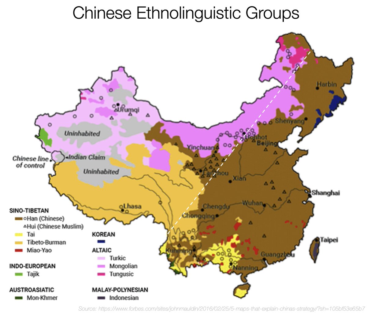
But most of the people are in the east! In the Han area.
This is so stark that the line that divides the lightly and densely populated areas has a name: it's the Hu line
This is so stark that the line that divides the lightly and densely populated areas has a name: it's the Hu line
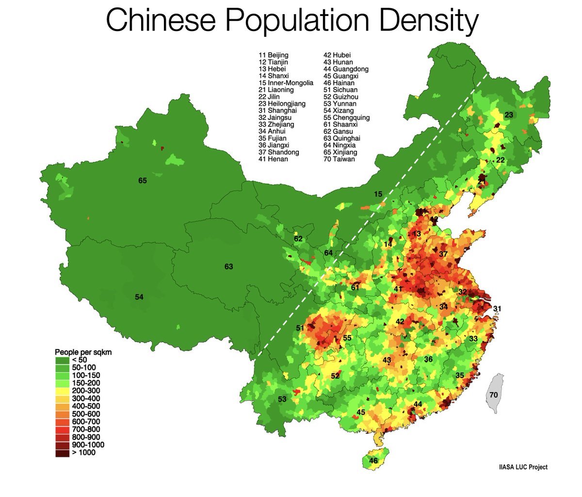
The area east of the Hu Line represents 43% of the land but hosts 94% of the population.

And the Han represent more than 95% of the population in those populated areas. That's why, overall, the Han account for 94% of the Chinese population!

But why is the area in the east so populated compared to the rest?
Because it's the flattest area, which means it's easy to farm and trade.
Because it's the flattest area, which means it's easy to farm and trade.

It's also the area that has the most rain. The white line here is the line that receives 15 inches of water a year. It divides the west, super dry, and the east, which receives much more than 15 inches

Of all the east, the most fertile area is that flat land to the northeast. It's called the North China Plain, and it receives not one but two rivers born in the Himalayas and Tibetan Plateau.

Unsurprisingly, it's the most fertile area in China.
This is where the Han come from.
This is where the Han come from.

More flatlands, rain, and rivers means more people and trade, which means they can conquer the rest of the areas around it over 3000 years.
But why does the rain fall where it falls?
Because winds at that latitude blow from the east, so they take with them all the water from the Pacific. The mountains stop the clouds, sucks all the water, and east of it there's a rain shadow effect and no rain.
Because winds at that latitude blow from the east, so they take with them all the water from the Pacific. The mountains stop the clouds, sucks all the water, and east of it there's a rain shadow effect and no rain.


So the mountains in the west and the latitude cause the rivers and the rain. But why are there mountains in the west in the first place? Because the Indian plate hits the Eurasian plate

The hit creates the Himalayas closest to India and the Tibetan plateau behind it.
Ok so now we understand why the mountains, but why do they stop so suddenly and the east is so flat?
Because of the Pacific plate! It's going below the Eurasian plate and all the area it has reached is flat on the surface!
Because of the Pacific plate! It's going below the Eurasian plate and all the area it has reached is flat on the surface!

How far in does the Pacific plate go? All the way to the... Hu Line!
(This limit is called the North-South Gravity Lineament, and separates from the Hu Line in the south).
(This limit is called the North-South Gravity Lineament, and separates from the Hu Line in the south).

So the Indian, Eurasian, and Pacific plate create China's mountains in the west & flatlands in the east
The latitude brings winds, which bring water
The relationship of both create rivers, rain, and flatlands
Those create fertile lands
The most fertile of which was the Han's
The latitude brings winds, which bring water
The relationship of both create rivers, rain, and flatlands
Those create fertile lands
The most fertile of which was the Han's
That's why the Hans were the most powerful, and why they spread.
So a better way to understand China is as the geologically-blessed Han country, defending itself by building non-Han buffers around it. For Beijing, China is the brown area, and the other colors are its defenses.
So a better way to understand China is as the geologically-blessed Han country, defending itself by building non-Han buffers around it. For Beijing, China is the brown area, and the other colors are its defenses.

How did this drive China's history? Their current policies? Their future?
Much more in this week's article.
Did you love this thread? Follow me, subscribe to my newsletter, and RT!
unchartedterritories.tomaspueyo.com/p/what-china-w…
Much more in this week's article.
Did you love this thread? Follow me, subscribe to my newsletter, and RT!
unchartedterritories.tomaspueyo.com/p/what-china-w…
• • •
Missing some Tweet in this thread? You can try to
force a refresh