Our new visual investigation shows how a secretive compound northeast of Kabul — the site of the Salt Pit, where the CIA previously tortured detainees — became the agency's hub for clandestine evacuations before parts of it were deliberately destroyed: nytimes.com/2021/09/01/wor…
Also known as COBALT and “the dark prison,” Salt Pit became operational in Sept. 2002 after Langley approved $200K for construction next to an abandoned brick factory. Image shows it in 2003. By late 2004, the agency stopped using the site as a prison, official documents suggest. 

The Salt Pit operated in full secrecy during those nearly two years. It was only in 2005 that the black site's existence became publicly known when @danapriest and others exposed how a detainee in CIA custody was stripped, shackled, and left to die. washingtonpost.com/wp-dyn/content…

So what happened to the CIA black site after 2004? Parts became Eagle Base to train Afghan counterterrorism units. Virtually no on-the-ground footage exist, so we analyzed nearly two decades of satellite imagery and spoke with sources to map out the highly secured compound.

The CIA first appeared to begin destroying buildings at the Salt Pit throughout April and May, a daily analysis of @planet satellite imagery shows. That's right after President Biden said the US would leave Afghanistan by September.

Interestingly, we know from historical satellite imagery that construction on these demolished buildings began between 2002 and 2004 — the years that US lawmakers say the CIA engaged in torture at the site.
More destruction appears to have occurred on Aug. 27, the day the Pentagon said US forces carried out controlled demolitions of their own equipment. NASA active-fire data, mapped here by @FIRIS_FireAlert, shows heat signatures across the CIA compound.

Eagle Base, where the CIA trained Afghan forces (see:
https://twitter.com/wesleysmorgan/status/1431050482982719491), was originally established the former brick factory but later expanded northward. These new structures — an apparent ammo depot and elaborate training site — were largely destroyed on Aug. 27.

The destroyed buildings very likely contained documents, hard drives, and other sensitive information, a former CIA contractor told @nytimes. Officials have confirmed that Eagle Base was destroyed. nytimes.com/2021/08/28/us/…
Before the CIA abandoned its last base in Afghanistan, it used the compound as an evacuation hub for Americans and Afghans who were likely to be targeted by the Taliban. We tasked a @planet satellite to take an image of the site on Aug. 24, showing dozens of vehicles lined up.

While Kabul's airport is only a 10-minute drive away, evacuees were flown by Mi-171E helicopters to Hamid Karzai International Airport to avoid Taliban checkpoints. Hundreds were evacuated this way between Aug. 15-28, people briefed on the operations told @nytimes.
This graphic shows three flights from Aug. 15 that show the routes these Mi-171E helicopters typically took over the past few weeks between the CIA site, HKIA and sometimes the Green Zone, including the U.S. Embassy compound.
Combined with these destinations, the types of aircraft used (Russian-made Mi-17s modified for heat) and their opaque ownership structures (U.S.-based ghost companies) provide clues that these flights were most likely designed to be covert and be involved in sensitive missions.
We found (and corroborated with flight data) that one of the Mi-171E helicopters was inadvertently captured in a livestream by @MARCATV, a Spanish news outlet, as it flew from HKIA to the CIA compound toward the compound on Aug. 20.
The CIA has previously acknowledged that it has flown Mi-17s — and even used one to enter Afghanistan back in Sept. 2001 to kick-start the war.

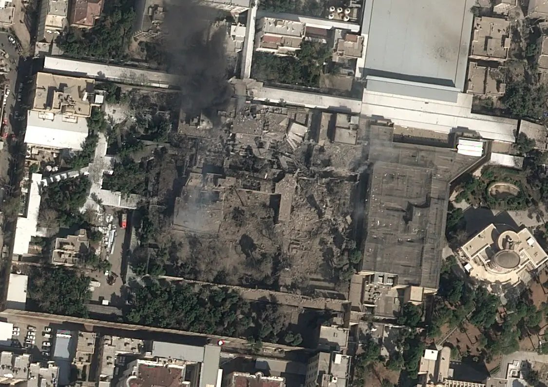
The evacuations and building demolitions at the CIA compound appeared complete by Aug. 28. Two days later, Taliban fighters were already inside, videos we geolocated to the Salt Pit show. “This was a very important place,” one says, as his camera panned across the wreckage.
The video above is, as far as I know, the first ever inside look into the Salt Pit. The site was so secretive that even on-the-ground photos from its interior are rare. I'll post all that we could verify in a different thread, here:
https://twitter.com/trbrtc/status/1433099617189744647
As always, these Visual Investigations are team work: @heytherehaIey @markscheffler @bottidavid @DrewJordan_NYT @dim109 @_pasr_
@julianbarnes @farnazfassihi @adamgoldmanNYT @brenna__smith @evanhill @kitty_bennett and Masood Farzan.
@julianbarnes @farnazfassihi @adamgoldmanNYT @brenna__smith @evanhill @kitty_bennett and Masood Farzan.
Also, big thanks to @planet, and all that reported on Salt Pit before, whether it's the first geolocation (@trevorpaglen in 2005!) or open source investigators and experts (thx @cencio4 for helping defining when a Mi-17 is Soviet-made, Russian-made or Soviet-designed).
We're continuing our coverage on Afghanistan and please feel free to reach out via DM, email or phone with tips and suggestions. You can see all our Visual Investigations here: nytimes.com/spotlight/visu…
Since publishing, we've found the clearest visual yet of one the US-operated Mi-17s mentioned in our story (thanks @UBannow). Here it is, offloading evacuees at the military side of HKIA. Flight data shows it had just returned from the heliport at the CIA compound.

• • •
Missing some Tweet in this thread? You can try to
force a refresh