
Time for my monthly #Yemen UAV roundup for August 2021. As always claimed means no visual confirmation.
1st - A Qasef is downed in Rabaha district, south Marib
1st - A Qasef is downed in Rabaha district, south Marib

2nd - Houthi forces shoot down a large quadcopter described as a reconnaissance drone in Hudaydah governorate. It's actually modified to drop 120mm mortal shells.
3rd - A Rased modified to drop 60mm mortar shells crashes north of Al-Jah, Hudaydah governorate.
4th - Saudis claim downing a bomb-laden UAV towards Khamis Mushait.
4th - Saudis claim downing a bomb-laden UAV towards Khamis Mushait.
4th - A Rased crashes in a refugee camp east of Marib

8th - A Dji Mavic 2 Pro/Zoom modified to drop a small explosive is shot down by pro-Gov forces in Baqim, Sa'ada. No, the 1st and 4th pic aren't the same.
9th - Saudis claim downing 2 bomb-laden UAVs towards Khamis Mushait.
9th - Saudis claim downing 2 bomb-laden UAVs towards Khamis Mushait.


13th - Saudis claim downing a bomb-laden UAV towards Khamis Mushait.
14th - Pro-gov forces claim downing 2 bomb-laden UAVs in Sirwah, west-Marib.
14th - Houthis down a Scan Eagle in Maghdal district, west-Marib.
19th - Saudis claim downing a bomb-laden UAV over Yemen, towards SA.
14th - Pro-gov forces claim downing 2 bomb-laden UAVs in Sirwah, west-Marib.
14th - Houthis down a Scan Eagle in Maghdal district, west-Marib.
19th - Saudis claim downing a bomb-laden UAV over Yemen, towards SA.
20th - Pro-gov forces down a Qasef in Al-Baqaa, Sa'ada.
22nd - Saudis claim downing a bomb-laden UAV towards Khamis Mushait.
24th - Saudis claim downing a bomb-laden UAV towards Khamis Mushait.
25th - Saudis claim downing a bomb-laden UAV towards Khamis Mushait.
22nd - Saudis claim downing a bomb-laden UAV towards Khamis Mushait.
24th - Saudis claim downing a bomb-laden UAV towards Khamis Mushait.
25th - Saudis claim downing a bomb-laden UAV towards Khamis Mushait.
26th - STC-forces down a Samad-1 in the Karsh area of Lahj governorate
26th - Pro-gov forces claim downing a drone on Kassara-front, west-Marib
27th - Saudis claim downing a bomb-laden UAV towards Khamis Mushait
28th - Saudis claim downing 2 bomb-laden UAVs towards Khamis Mushait
26th - Pro-gov forces claim downing a drone on Kassara-front, west-Marib
27th - Saudis claim downing a bomb-laden UAV towards Khamis Mushait
28th - Saudis claim downing 2 bomb-laden UAVs towards Khamis Mushait

29th - Saudis claim downing 3 bomb-laden UAVs towards Khamis Mushait.
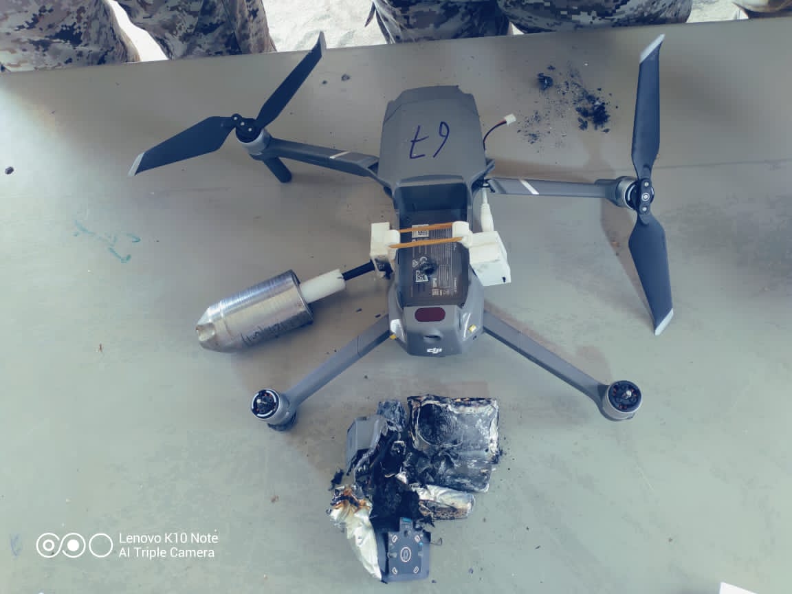
30th - Pro-gov forces down a modified DJI Mavic 2 Pro/Zoom on Kassara front, West-Marib.
30th - A Samad-1 crashes in Al-Nadira district, Ibb governorate.
30th - Pro-gov forces down a modified DJI Mavic 2 Pro/Zoom on Kassara front, West-Marib.
30th - A Samad-1 crashes in Al-Nadira district, Ibb governorate.


31st - Saudis claim downing 2 bomb-laden UAVs, both close to Abha airport, the shrapnel of the second injured 8 and caused material damage to among other stuff, an Airbus A320. Pictures are of the remains of the second drone, it's a Qasef.


That's it for this month. Not much out of the usual. Uptick in attacks on SA at the end of the month mirrors escalation in Marib, keeping a few F-15s away from the battlefield.
• • •
Missing some Tweet in this thread? You can try to
force a refresh


