Thread of interesting Aerial imagery from the aftermath of Hurricane Ida that struck Louisiana last weekend.
Over a dozen large oil/gas containers swept around 250m from the lot they were parked in in Port Fouchon.
storms.ngs.noaa.gov/storms/ida/ind…
Over a dozen large oil/gas containers swept around 250m from the lot they were parked in in Port Fouchon.
storms.ngs.noaa.gov/storms/ida/ind…

A group of tugboats and debris in Port Fouchon. The ship most rotated is the Crosby Guardian marinetraffic.com/en/photos/of/s…

A large boat shelter in Port Fouchon looking quite obliterated. storms.ngs.noaa.gov/storms/ida/ind…

A repair dry-dock (?) having become demoored and washed ashore up to 2km away (it is hard to tell where in the floatation canal the boat came from) storms.ngs.noaa.gov/storms/ida/ind…


The majority of houses in this small hamlet have literally disintegrated. The pre-event imagery is from March 2019. Nearby the bayou is littered with the remains of these houses. One roof sits mostly intact around 300m away.
storms.ngs.noaa.gov/storms/ida/ind…
storms.ngs.noaa.gov/storms/ida/ind…


More houses in Cheniere Caminada where all that's left is the stilts. The 2nd picture shows the same area after Hurricane Zeta last October.


Grand Isle, a settlement built ontop of a barrier island to Caminada Bay has more intact houses - just, but the storm-surge shows devestation and that the island had basically become the seafloor.


This building is the Grand Isle Fire Station, where the roughly 40 people who did not evacuate the island waited out the storm. The surge began to flood the building, but it is mostly fine, and on August 30th (when the image was taken) was still a hub of activity.

A 30-50m section of the Grand Isle State Park fishing pier got destroyed in the storm.
storms.ngs.noaa.gov/storms/ida/ind…
storms.ngs.noaa.gov/storms/ida/ind…


The St Vincent, a shrimp fishing boat, washed up near Leeville, LA. It's not often that you see a boat at this angle from the sky.
The boat was swept around 250m from its moorings.
You can see this boat and its owner in better times here:
montgomeryadvertiser.com/picture-galler…
The boat was swept around 250m from its moorings.
You can see this boat and its owner in better times here:
montgomeryadvertiser.com/picture-galler…

Leeville itself was pretty hard hit, with a lot of structures being obliterated. Thankfully most appear to be sheds for trailer homes, which (hopefully) had evacuated before the storm.


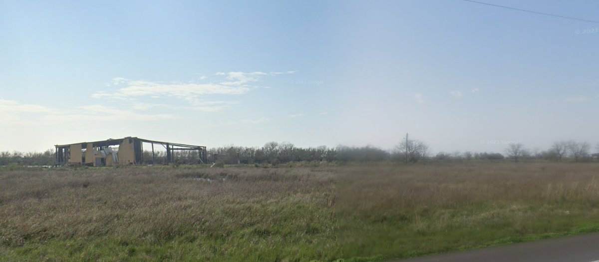
The deterioration of this house and fishing-shed on the Louisiana coast since 2008. I can imagine how many hurricanes it's seen.
2008 > 2013 > Feb 2021 > Aug 31 2021 (red circle shows where the house used to be).
2008 > 2013 > Feb 2021 > Aug 31 2021 (red circle shows where the house used to be).


Before Ida there were 36 structures just outside of the Golden Meadows levee. After this storm there's only even the remnants of three.
It really shows the importance and the engineering genuis behind the Gulf Coast's levee system.
It really shows the importance and the engineering genuis behind the Gulf Coast's levee system.


The post-hurricane imagery also shows that the floodwater or storm surge (seen by the remaining debris) came sooo close to overtopping the levee. The height data here is just from Google Earth, so not perfect, but it shows just how close!


The levee also marks the final checkpoint on the LA-1 highway down South. Beyond this checkpoint there was only a single car visible on the road (barring cars that presumably stayed in Grand Isle). It shows that even first-responders had hardly made it to the coast by Aug 31.

Despite the levee keeping the storm-surge out, the wind damage in Golden Meadows is immense. A fair few houses oblitereated here too. Looks as though the whole area was hit by a strong tornado, which shows the force of the winds. Really hope everyone left the town.


I wonder what happened here...

Some of the blue tarps already going up by August 31st in Golden Meadows, but still a hell of a lot of clean-up to go. Not sure that rebuilding this close to the gulf-coast is wide, considering what the sea level is up to.


The number of fallen trees here really shows the wind too.

The line at the fuel station in Golden Meadows stretched 900m on August 31st...
The electric vehicle charging station (2nd/3rd pic), not so much. It has also been largely destroyed by the wind.
The electric vehicle charging station (2nd/3rd pic), not so much. It has also been largely destroyed by the wind.


A decent number of vehicles parked at the trailer park in Bayou Resort have been destroyed. Truely hope that all of the occupants managed to find another way to leave before the storm. storms.ngs.noaa.gov/storms/ida/ind…

• • •
Missing some Tweet in this thread? You can try to
force a refresh