The geography of Egypt is bonkers 🇪🇬🌍
Look at that image of the Middle-East by night. See that "flower" in the middle? That is the Nile.
Egypt has 105 MILLION ppl!
99% of them live in that light area!
That's 3% of its territory!
What else is crazy about Egypt's geography?
🧵
Look at that image of the Middle-East by night. See that "flower" in the middle? That is the Nile.
Egypt has 105 MILLION ppl!
99% of them live in that light area!
That's 3% of its territory!
What else is crazy about Egypt's geography?
🧵
The Nile's banks are between 0.5km and 20km wide (~0.3 to 12 miles). 105M ppl live in that area plus the delta. Crazy. They do that because it's fertile AF
What's outside though? Nothing.
What's outside though? Nothing.

In the west, there's nothing for thousands of miles. There's so much nothing that in 5000 years of history, Egypt has NEVER been successfully invaded from here.
Even the nazis tried and failed.
Even the nazis tried and failed.

Why is it so damn dry? Well, weather is not nice.

Why is it so bad? Because Egypt is in the Horse Latitude. They have deserts across the world.
Why is that bad? More details here:
unchartedterritories.tomaspueyo.com/p/a-space-craf…
Why is that bad? More details here:
unchartedterritories.tomaspueyo.com/p/a-space-craf…

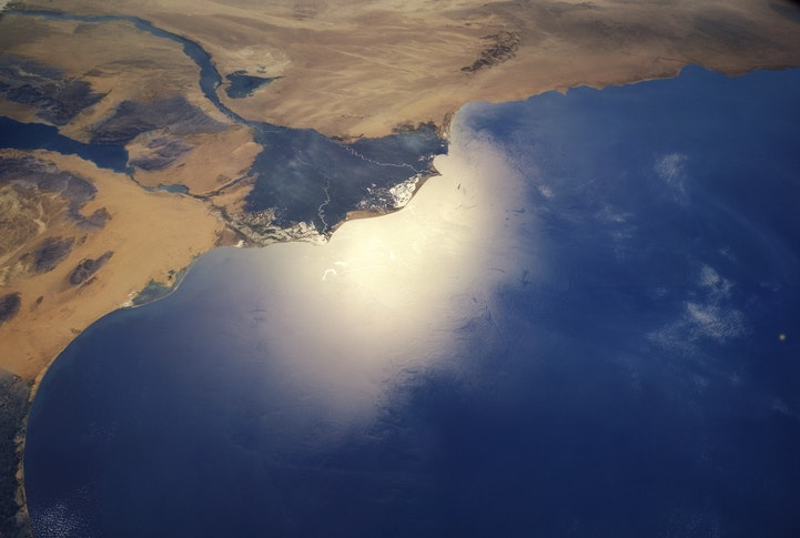
Look at the south. The lights stop abruptly. Why? Does the Nile stop there? Not at all. It continues for thousands of miles. What then?
The Aswan Dam
The Aswan Dam

The Aswan Dam has created a huge lake. The southern border of Egypt goes through that lake, quite close to the dam.
Isn't that weird? Why is the same point a dam, a border, and the limit of lights and population of a country that packs 105M ppl in such a small place?
Cataracts
Isn't that weird? Why is the same point a dam, a border, and the limit of lights and population of a country that packs 105M ppl in such a small place?
Cataracts
See, the Nile flows very slowly across all of Egypt. But not before. Aswan is where the Nile's 1st cataract was. Then there are a bunch more upstream.
Really, Egypt's length was defined by the place of a cataract.
What do they look like?
Really, Egypt's length was defined by the place of a cataract.
What do they look like?

Nothing crazy. They're just points where water is faster, rocks appear on the surface, and some banks of sand might accumulate.
What's the big deal then?
This is where the Nile is not navigable anymore.
So Egypt couldn't easily incorporate it into their empire.
What's the big deal then?
This is where the Nile is not navigable anymore.
So Egypt couldn't easily incorporate it into their empire.

Different kingdoms appeared over time. That area to the south was called Nubia.
Egypt & Nubia mixed over millennia, but still remained different enough that that area to the south is a different country, Sudan
Egypt & Nubia mixed over millennia, but still remained different enough that that area to the south is a different country, Sudan
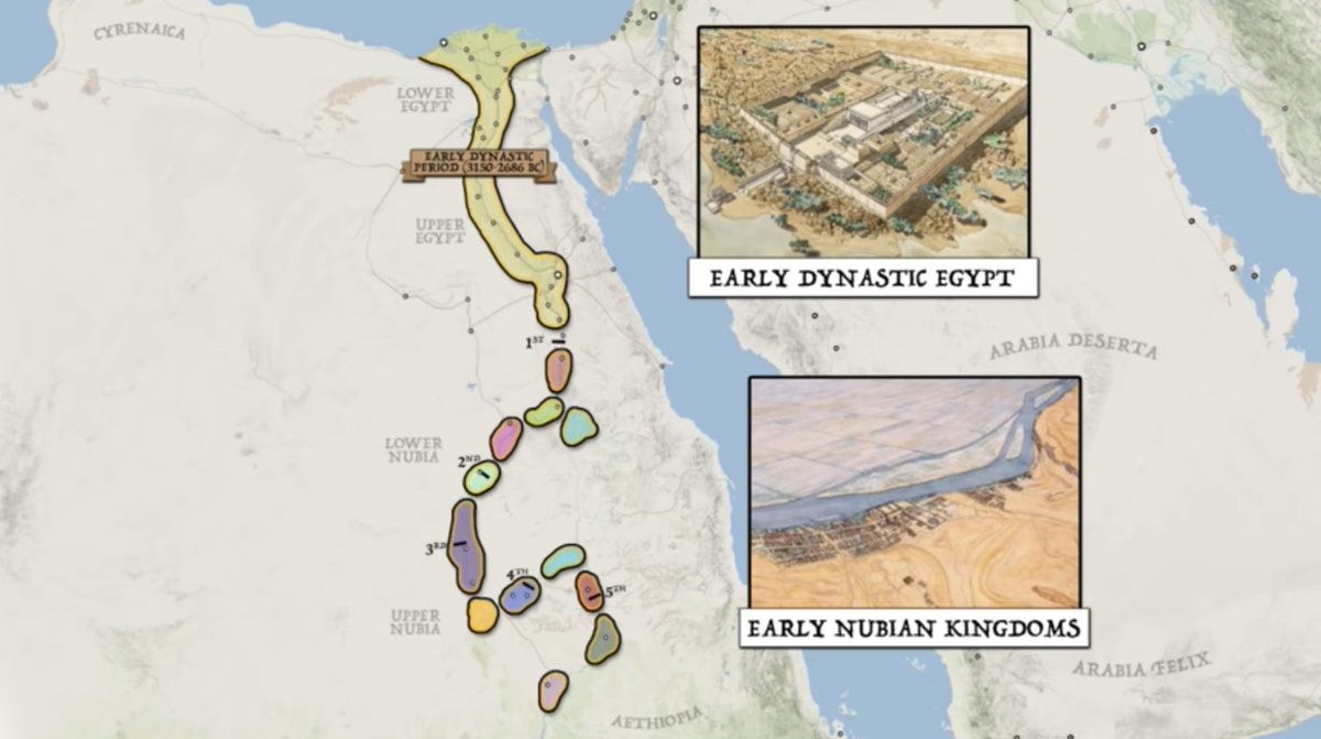
The banks of the Nile there are narrower.
Between the narrower banks, the faster flow, and the fact that it's not navigable, Sudan is much poorer and has a smaller population. They can't even afford as much electricity as Egypt—which is partially why the lights stop at Aswan
Between the narrower banks, the faster flow, and the fact that it's not navigable, Sudan is much poorer and has a smaller population. They can't even afford as much electricity as Egypt—which is partially why the lights stop at Aswan

What's in the north? The delta
It's beautiful.
You know what it's not? Navigable.
40% of the population and 50% of the crops come from there, but the Nile spreads so much that trade ships can't navigate.
It's beautiful.
You know what it's not? Navigable.
40% of the population and 50% of the crops come from there, but the Nile spreads so much that trade ships can't navigate.
That means that, despite being the oldest civilization on the Mediterranean, Egypt was never a naval power.
It's not just that the Nile can't be navigated. It's also that Egypt has no room for trees. No trees, no wood, no ships, no trade, no navy.
Poor and exposed.
It's not just that the Nile can't be navigated. It's also that Egypt has no room for trees. No trees, no wood, no ships, no trade, no navy.
Poor and exposed.
If you were clever, where would you put your capital in such a country?
Pharaohs had thousands of years to think about it, and usually picked the point between the delta and the Nile proper.
That's Cairo today.
Pharaohs had thousands of years to think about it, and usually picked the point between the delta and the Nile proper.
That's Cairo today.

And funnily the Suez Canal is a stone throw's away from there.

Big deal, because the Suez Canal accounts for a huge share of Egypt's foreign currency.

How did this influence its history?
The pharaohs?
Why was Egypt invaded so many times?
Why is it poor?
Why is it friendly with Israel?
With the US?
Why the military pushed aside the Muslim Brotherhood?
It all comes down to geography.
The pharaohs?
Why was Egypt invaded so many times?
Why is it poor?
Why is it friendly with Israel?
With the US?
Why the military pushed aside the Muslim Brotherhood?
It all comes down to geography.
I answer all these questions in this article (this one is paid)
unchartedterritories.tomaspueyo.com/p/egypt
unchartedterritories.tomaspueyo.com/p/egypt
Want more? Follow me or sign up to my newsletter. I will write many more threads about this. Or other similar threads. For example this one about China
unchartedterritories.tomaspueyo.com/p/what-china-w…
Or about the world and the US
unchartedterritories.tomaspueyo.com/p/world-chessb…
Or about the Caribbean
unchartedterritories.tomaspueyo.com/p/a-brief-hist…
unchartedterritories.tomaspueyo.com/p/what-china-w…
Or about the world and the US
unchartedterritories.tomaspueyo.com/p/world-chessb…
Or about the Caribbean
unchartedterritories.tomaspueyo.com/p/a-brief-hist…
• • •
Missing some Tweet in this thread? You can try to
force a refresh