You might have seen that Spain 🇪🇸 is growing: 🌋🏝️
A perfect time to continue our geoweirdness thread series with a look at Spain
🌍⁉️👇
https://twitter.com/red_baobab/status/1443475051903389700
A perfect time to continue our geoweirdness thread series with a look at Spain
🌍⁉️👇
2/ First up, most people think Spain 🇪🇸 is only in Europe, but Spain has two “Ciudades autónomas” in northern Africa : Cueta and Melilla en.wikipedia.org/wiki/Ceuta
en.wikipedia.org/wiki/Melilla

en.wikipedia.org/wiki/Melilla


3/ Spain 🇪🇸 also has an enclave completely surrounded France 🇫🇷: the village of Llívia
en.wikipedia.org/wiki/Ll%C3%ADv…

en.wikipedia.org/wiki/Ll%C3%ADv…


4/ As we covered in our thread about border disputes a few months ago, Spain 🇪🇸 and France 🇫🇷 share Pheasant Island, an unoccupied island in a river between the countries: en.wikipedia.org/wiki/Pheasant_…
https://twitter.com/OpenCage/status/1372514781178040321
5/ Spain has a few disputed territories. The Olivenza region is claimed by neighboring Portugal 🇵🇹. en.wikipedia.org/wiki/Olivenza#… 


6/ Happily the dispute with Portugal 🇵🇹 is not a source of stress, and there is no trouble between the two EU 🇪🇺 countries. Farther south you can actually cross the border by zipline, see: limitezero.com/en/ 


7/ A long running Spanish 🇪🇸 border dispute is with the UK 🇬🇧 about who owns Gibraltar 🇬🇮. The situation has been made more complicated by Brexit en.wikipedia.org/wiki/Effect_of… 

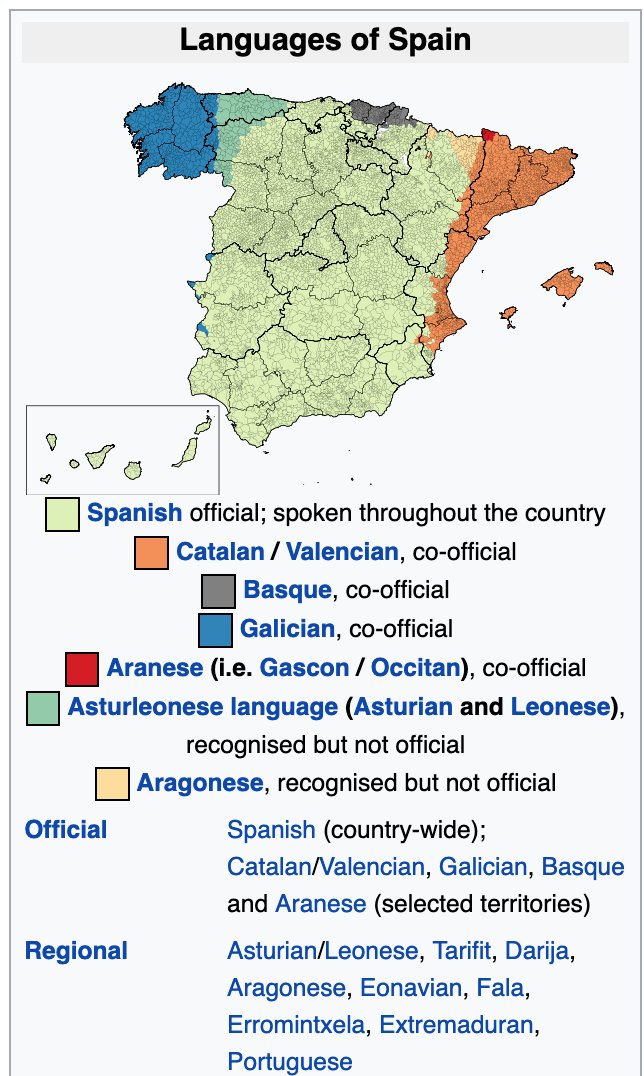
9/ this diversity is reflected in OpenStreetMap communities. It’s been our pleasure to interview some here on the blog: OSM Basque Country: @garaolaza
blog.opencagedata.com/post/100820580…
OSM in Catalan @OSMcatala blog.opencagedata.com/post/118777421…
OSM in Galicia @osmgalicia
blog.opencagedata.com/post/openstree…
blog.opencagedata.com/post/100820580…
OSM in Catalan @OSMcatala blog.opencagedata.com/post/118777421…
OSM in Galicia @osmgalicia
blog.opencagedata.com/post/openstree…
10/ The communities within Spain have many, often disagreeing, viewpoints. Including even about whether they are part of Spain. A dynamic situation, as most recently seen in 2017 with the unilateral declaration of independence of the Republic of Catalonia en.wikipedia.org/wiki/Catalan_d… 


11/ Final geoweird point: Spain’s 2nd largest city is beautiful Barcelona, one of the top destinations in Europe. Often confusing for tourists, though, is that the city maps do NOT have north 🧭 at the top. 


12/ We hope you enjoyed our look at the geoweirdness of Spain 🇪🇸. We have more about border disputes, exclaves, geocoding, etc listed on our blog: blog.opencagedata.com/post/geothread… More countries and regions in the coming weeks and months 

• • •
Missing some Tweet in this thread? You can try to
force a refresh


