Why is Africa the way it is?
Why are its countries where they are?
The relationships between them
The people? The deserts?
Here are X to easily understand Africa better (politics, geography, history, demographics, climate & more)
Why are its countries where they are?
The relationships between them
The people? The deserts?
Here are X to easily understand Africa better (politics, geography, history, demographics, climate & more)

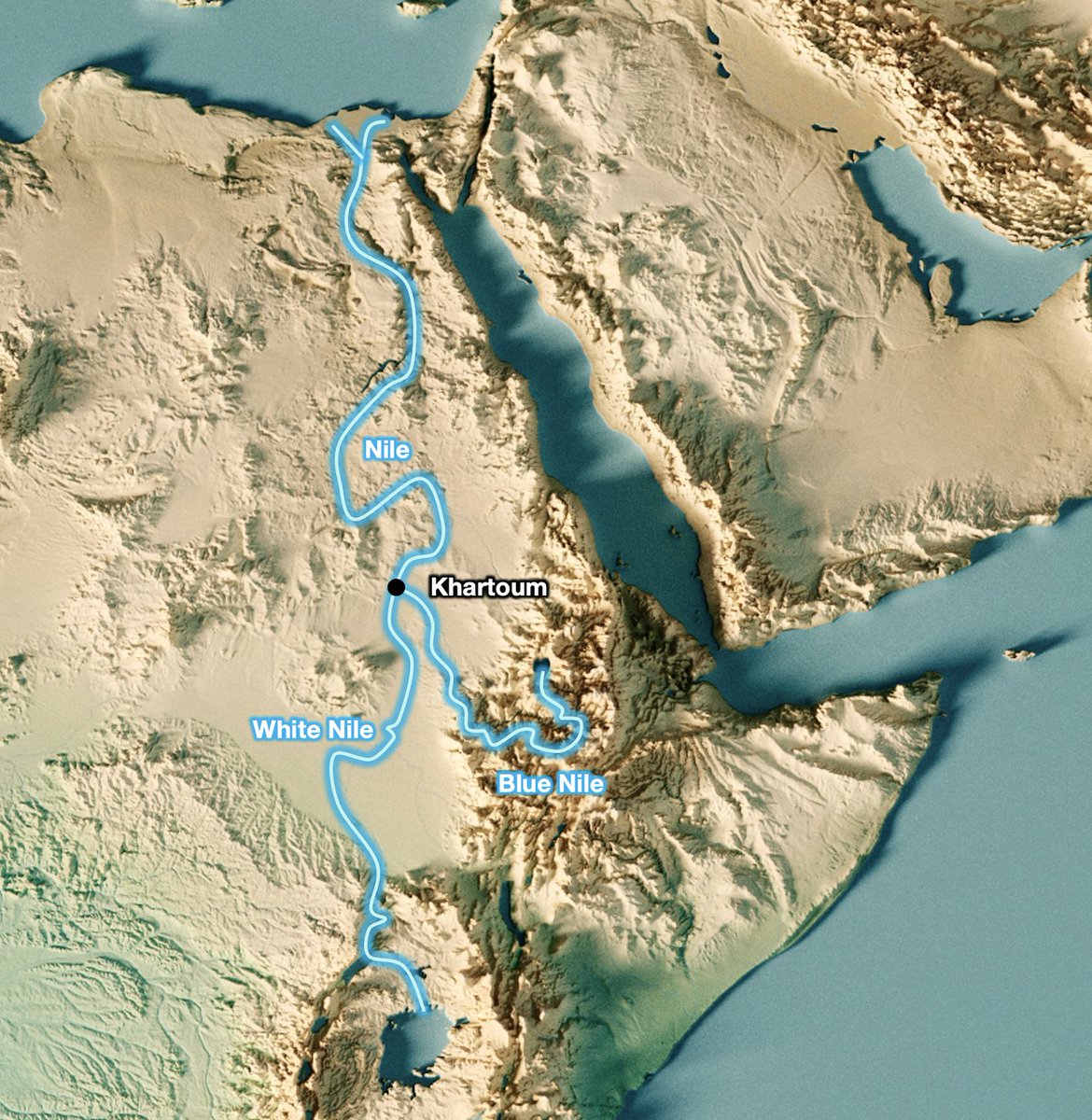
One of the key ways to look at Africa is through this map: its river basins.
Let's start with the big one in the northeast. It's the Nile's watershed.
Let's start with the big one in the northeast. It's the Nile's watershed.

Here's northeast Africa at night. See that flower in the middle? That's the Nile through Egypt.
100 million Egyptians live within ~15 miles of its banks. That's ~99% of them.
More details here.
Why?
100 million Egyptians live within ~15 miles of its banks. That's ~99% of them.
More details here.
https://twitter.com/tomaspueyo/status/1441223770706898944?s=20
Why?
Because all the rest is just desert. The Sahara. But why is the Sahara where it is? Because of Horse Latitudes

Across the world, at that latitude—called horse latitude—there are hot deserts.
But why?
Because of winds
But why?
Because of winds

The equator is so hot that air goes high up in the atmosphere, where it gets cold and its water falls.
Due to the size of the earth, that air falls down at the horse latitudes. Dry air falling means no rain.
Due to the size of the earth, that air falls down at the horse latitudes. Dry air falling means no rain.
Morocco, Algeria, and Tunisia are just at the limit of Horse Latitudes, have humidity from the Mediterranean sea, and the Atlas mountains condensate the water from the wind. So there's enough water on the north of the Atlas mountain range—so ppl—but nothing south.

That sliver of green in Northwest Africa hosts 92M Africans.
But farther east it's too far south into the Horse Latitudes, so even if Libya is bigger than Morocco, Tunisia, and Egypt combined, it only has 5M ppl!
But farther east it's too far south into the Horse Latitudes, so even if Libya is bigger than Morocco, Tunisia, and Egypt combined, it only has 5M ppl!
If you look at the river basins in the Sahara, you can see few of these rivers end in the sea: they dry up before they arrive.

Only the Nile manages to cross the Sahara. In fact, it's so unique, it's the longest north-south river in the world.

But where is it born? The Nile is the combination of the White Nile from Lake Victoria, in the middle of Africa, and the Blue Nile, from Ethiopia.
What ppl don't know is that ~90% of the water of the Nile comes from Ethiopia!
Why?
Again, because of rains, obviously
What ppl don't know is that ~90% of the water of the Nile comes from Ethiopia!
Why?
Again, because of rains, obviously
It makes sense that the equator has so much rain, but why Ethiopia? Because of its highlands

Ethiopia's highlands are super high, so they catch all the water from the winds blowing into it.

Here's a closeup of the Ethiopian Highlands. Very high

Why does Ethiopia have so much rain but Somalia is so dry? Because once winds pass Ethiopia, they're empty of water. It's called the rain shadow effect.

But why do winds blow in this direction in Africa, from west to east, and not the other way around? Because of the monsoon winds.
In june-sept, winds blow from the Atlantic towards Africa, bathing the continent with water.
In dec-mar, when the hottest part is farther south, they blow from the Indian Ocean.
In dec-mar, when the hottest part is farther south, they blow from the Indian Ocean.

That's why Somalia is dry: by the time the jun-sep winds reach it, all the water fell in the Ethiopian highlands.
It's also why the Kalahari (esp Namibia) and the west of South Africa are so dry: by the time eastern winds arrive in jan-mar, all their water has already fallen
It's also why the Kalahari (esp Namibia) and the west of South Africa are so dry: by the time eastern winds arrive in jan-mar, all their water has already fallen

Obviously, the more rain, the more food, the more ppl. That's why the map of water precipitation in Africa matches the map of population density pretty well
Except for that hole in the middle. What is that?
Around the equator, land is actually not fertile at all. It's so hot and humid that plants and animals recycle waste extremely fast, before sediments litter the floor. And then rain washes away any potential fertilizer
Around the equator, land is actually not fertile at all. It's so hot and humid that plants and animals recycle waste extremely fast, before sediments litter the floor. And then rain washes away any potential fertilizer
That's why the same thing happens at the Amazon in America: it's not fertile land, and few live there.
So although the Congo (middle green) is huge and has lots of water, it "only" has 90M ppl (to Nigeria's 200M)
But why are there so many mountains stopping rains across Africa?
So although the Congo (middle green) is huge and has lots of water, it "only" has 90M ppl (to Nigeria's 200M)
But why are there so many mountains stopping rains across Africa?

Because of the Rift Valley: 2 mountain ranges with a valley in the middle that cross Africa.
These are the mountains that stop all the monsoon water that later become so many rivers, including the Nile.
And why is the Rift Valley there? Because of plate tectonics.
These are the mountains that stop all the monsoon water that later become so many rivers, including the Nile.
And why is the Rift Valley there? Because of plate tectonics.

Africa is splitting in two in the Rift Valley. The plates are separating at that level. Central African lakes Victoria, Tanganyka, Malawi, and others are just the central Rift valley trapping water from the 2 mountain ranges on the sides

So there you are: the earth's plate tectonics and size cause Africa's mountains and winds, which cause the continent's geography, and create all these climates where humans thrive—or not:
- Egypt's Nile feeds 100M ppl
- Morocco, Algeria, Tunisia are the Med coast above the Atlas
- Egypt's Nile feeds 100M ppl
- Morocco, Algeria, Tunisia are the Med coast above the Atlas
- Libya is nothing because it has no water. Same as most Saharan countries
- The few Saharan countries that survive live around internal lakes: eg Chad / Niger around Lake Chad
- Ethiopia's highlands catch wind's water, which supports 120M ppl
- The few Saharan countries that survive live around internal lakes: eg Chad / Niger around Lake Chad
- Ethiopia's highlands catch wind's water, which supports 120M ppl
- But Somalia has none left, so it's desert
- The Rift Valley creates rivers and lakes that can feed populations: Uganda, Rwanda, Burundi, Malawi, Zimbabwe..
- Tanzania, Kenya, Mozambique, and South Africa get enough water from eastern monsoon winds that they can support big pops
- The Rift Valley creates rivers and lakes that can feed populations: Uganda, Rwanda, Burundi, Malawi, Zimbabwe..
- Tanzania, Kenya, Mozambique, and South Africa get enough water from eastern monsoon winds that they can support big pops

- Namibia doesn't, so it's desertic. Southern Angola isn't great either. But the north could have a bigger population
- Congo: too hot and humid to be fertile, so its population is limited.
- Congo: too hot and humid to be fertile, so its population is limited.
- But the West Africa pop is huge: it has humidity + heat w/o too much as the Congo. That's all the countries btw Senegal & Nigeria
I go into more detail on all of this in this week’s article
Sign up to my newsletter to receive articles like this.
unchartedterritories.tomaspueyo.com/p/ethiopian-re…
I go into more detail on all of this in this week’s article
Sign up to my newsletter to receive articles like this.
unchartedterritories.tomaspueyo.com/p/ethiopian-re…
And if you learned from this thread, follow and retweet!
Back to the top
Back to the top
https://twitter.com/tomaspueyo/status/1458200256626270214?s=20
• • •
Missing some Tweet in this thread? You can try to
force a refresh