Exceptional warmth spreading into the Central U.S. with some places seeing temperatures 30-35 degrees above normal Wednesday and Thursday: wapo.st/3lpySuV 1/x
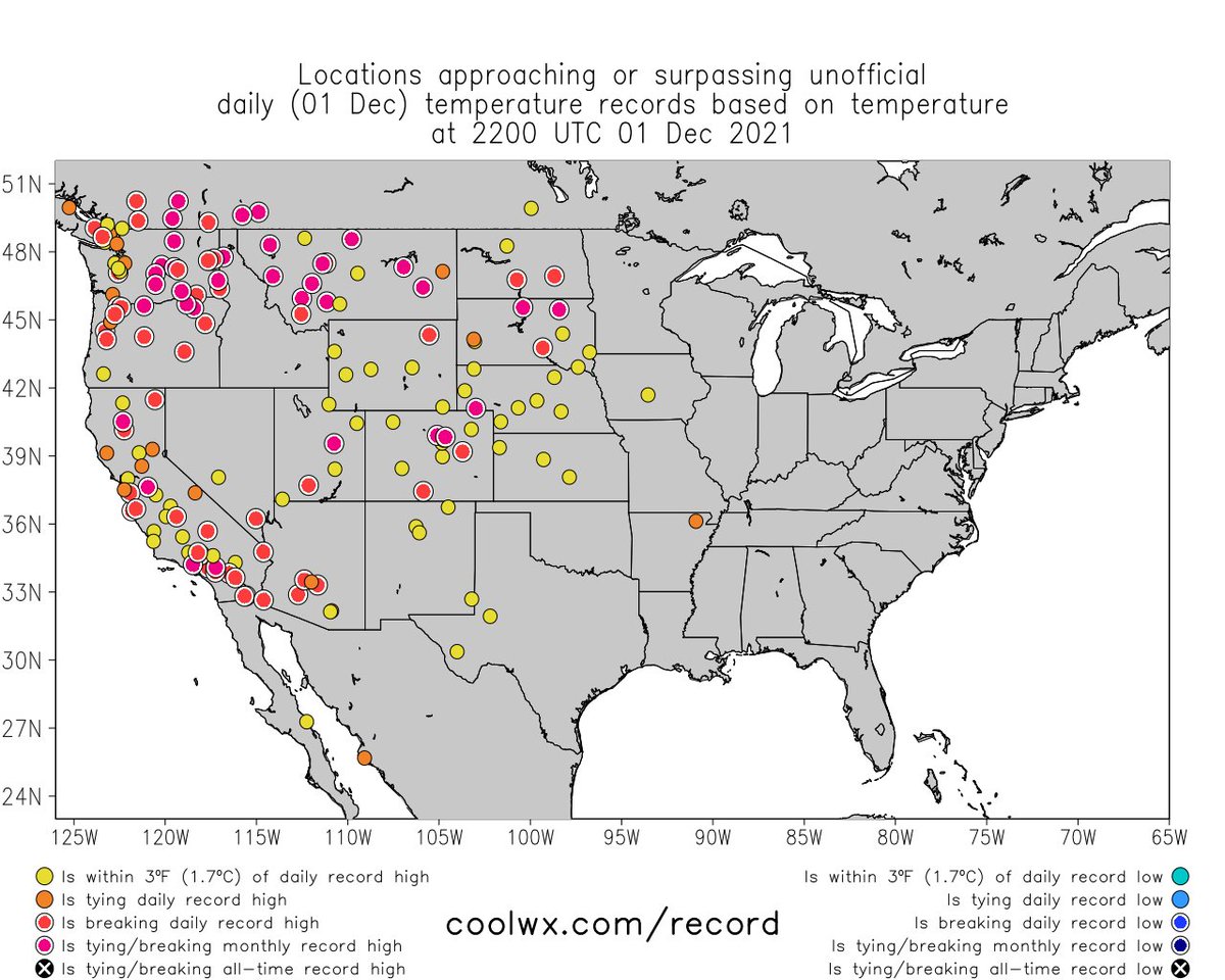
Dozens of record highs are set to be broken the next two afternoons. Many parts of the central U.S. seeing highs well into the 60s and 70s. 2/x
Where's the snow? There's hardly any of it. Just 10 percent of nation has snow cover, second lowest on record for Dec. 1 (since 2003). Mountain snowpack is well below normal over most of West. 3/x
Lower 48 is warm and so are many land areas around the world. The chill is confined to Alaska, NW Canada, Scandinavia and northern Russia. Yes, climate change contributes to the expansiveness of warmth and prevalence of red. 4/4
Update: look at all of the places setting daily or monthly (December) record highs:
• • •
Missing some Tweet in this thread? You can try to
force a refresh
DC winter outlook THREAD: First, let's share our snowfall map--these are our predicted amounts for the ENTIRE winter. While not particularly impressive, they would beat last winter's totals: 1/x
An important note on the snowfall forecast: While we're predicting below-average amounts for the 5th time in the past 6 winters, it would just take one blockbuster storm to surpass it. The thing is though, La Ninas - which we have this year - lower the odds of a big snow. 2/x
During La Ninas, winter storms tend to track to our west, drawing in mild air from the south. So we can get some snow, but usually in modest amounts before it changes to ice and rain. 3/x
Powerful storm off Pac Northwest coast (yes, another bomb cyclone) has driven heavy rain, mountain snow into northern Calif to Washington. It's also catalyst for storm that will develop in Plains with snow/high winds in Dakotas, N Minnesota late week. wapo.st/3khWqRF 1/x
Pacific Northwest really getting hammered with precipiation--this is very typical of La Ninas. Map here is forecast precip through Friday morning: 2/x
As storm develops in northern Plains/Upper Midwest, heavy snow and strong winds likely to be big issue for northeast North Dakota and northern Minnesota, Thursday night and Friday - specific amounts still coming into focus. La Nina also favors harsh winter in this area: 3/x
The warm weather has been holding back fall colors in the Mid-Atlantic; you have to head high into the mountains to see much. BUT... cooler temperatures inbound should help to move colors along in the next week: wapo.st/3j5n3c9
Generally the best color right now is 2-3+ hours west of DC, at elevations above 2,000 feet... like right here:
Who's ready for the return of fall-like weather? This graphic shows the predicted 24 hour temperature change Saturday into Sunday. Here's our article on the big transition: wapo.st/2XgGdUN (1/x)
Along the big cold front coming east, there is an elevated chance of strong to severe storms, today in the Tennessee and Ohio Valleys and in the Mid-Atlantic and Northeast Saturday. (2/x)
Got outdoor plans Saturday afternoon around Richmond/DC/Baltimore/Philly? Be prepared for an interruption. Gusty showers/storms probable mid-late-afternoon. Shouldn't last long. (3/x)
COLD West, WARM East - look at the temperatures this morning - substantially colder in Arizona than Maine. Here's our story on this remarkable divide: wapo.st/3BH3RbM ... And we have a few more stats to share...THREAD (1/x)
The storm that drew the cold air into the West was a BIG snow producer. Up to 28" in Montana and 27" in western South Dakota. Impressive 3-day totals shown on this map. (2/x)
Caribou, Maine yesterday set a record high of 77 degrees and was warmer than Phoenix, which only made it to 75. (3/x)
The contrasting weather between the western and eastern U.S. is rather remarkable. Consider this: Phoenix and Las Vegas have been colder than Chicago and Boston recent mornings: wapo.st/3BH3RbM (1/x)
LOTS of snow has been falling in the West. Up to 28" in Montana and amounts over a foot in the mountains of Utah, Colorado, Wyoming and Idaho. Western South Dakota hammered with blizzard conditions today - up to 22" of 70+ mph winds. (2/x)
Meanwhile, it's been warm in the East for 10 days and is about to get warmer! Predicted highs on Friday. (3/x)