
Some model output is currently calling for a very vigorous depression to run by the far NW of the #UK overnight Sunday into Monday... a thread.
A very nice example of a Shapiro-Keyser evolution.
1) Initial development (00Z Sun) takes place in the jet right-entrance. @wxcharts
A very nice example of a Shapiro-Keyser evolution.
1) Initial development (00Z Sun) takes place in the jet right-entrance. @wxcharts


2) 15 hours later - strong, active warm front, and weak, fractured cold front. Main air mass change to the rear of the developing seclusion.
Typical S-K cyclones forming in the W Atlantic stretch E-W in zonal upper flow, this one stretches N-S as the upper pattern is amplified.
Typical S-K cyclones forming in the W Atlantic stretch E-W in zonal upper flow, this one stretches N-S as the upper pattern is amplified.

2a) At the same time, differential cold advection taking place around the developing depression generates a strengthening jet-streak...
... the pattern wavelength is shortening and the system begins "self-development" as it creates its own jet left-exit.
... the pattern wavelength is shortening and the system begins "self-development" as it creates its own jet left-exit.

3) The actual #winds realised will in part be determined by exactly when the low feels maximum forcing from this jet left-exit, generating the strongest gradients.
Given the system is yet to get going, there is typical model and model run variation in when this occurs.
Given the system is yet to get going, there is typical model and model run variation in when this occurs.

4) Another consideration with SK cyclones is the potential for a "sting-jet" (SJ), which, should one form, would occur just ahead of the strongest W'ly winds in the "cold-conveyor" (CCB), and behind the cold front.
These aren't resolved by global models, due to their small size.
These aren't resolved by global models, due to their small size.

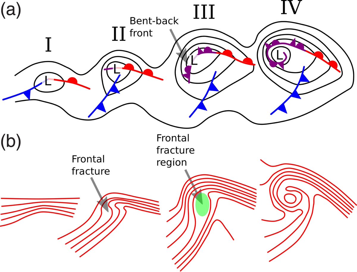
5) This is the canonical evolution of a Shapiro-Keyser cyclone, with its distinctive fractured cold front and back-bent warm-front (sometimes analysed as an occlusion)
6) Finally, another characteristic of these types of system are their "warm-cores", as the warm air mass wraps into the centre and "secludes".
This cyclone phase diagram shows that it is forecast to evolve into a system with a symmetric warm core as it heads N of the UK.
This cyclone phase diagram shows that it is forecast to evolve into a system with a symmetric warm core as it heads N of the UK.

7) References:
wxcharts.com - maps
rmets.onlinelibrary.wiley.com/doi/10.1002/we… - conceptual mode
rmets.onlinelibrary.wiley.com/doi/full/10.10… - SK evolution
moe.met.fsu.edu/cyclonephase/ - phase diagrams.
wxcharts.com - maps
rmets.onlinelibrary.wiley.com/doi/10.1002/we… - conceptual mode
rmets.onlinelibrary.wiley.com/doi/full/10.10… - SK evolution
moe.met.fsu.edu/cyclonephase/ - phase diagrams.
8) I should add that both @metoffice and @MetEireann currently have wind warnings in force, and to regularly check their pages for updates as this system evolves.
Met Office warning currently (1625Z on 11th Dec) flags potential for MEDIUM impacts.
metoffice.gov.uk/weather/guides…
Met Office warning currently (1625Z on 11th Dec) flags potential for MEDIUM impacts.
metoffice.gov.uk/weather/guides…


• • •
Missing some Tweet in this thread? You can try to
force a refresh


