1/ Netherlands real problem: demographics.
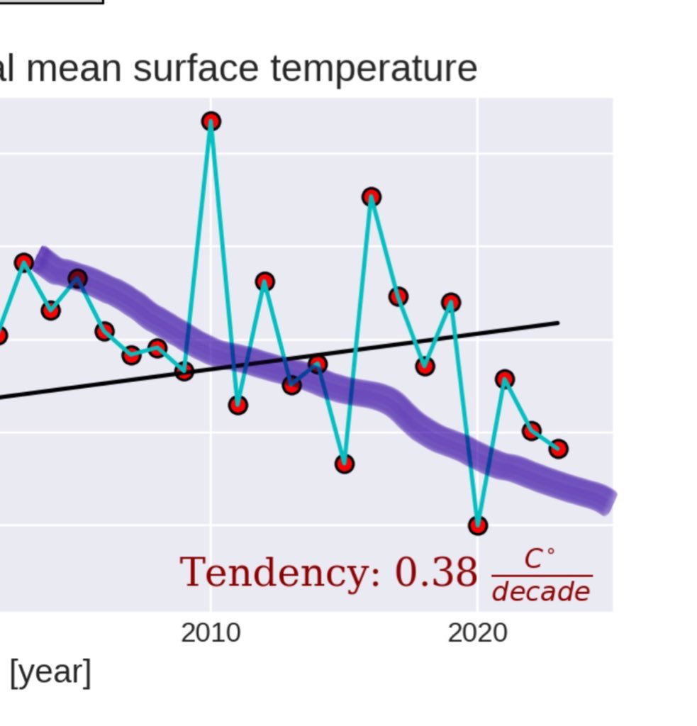
NL: The red line (crude mortality) is increasing. This is demographics driven. It manifest as ICU and hospital load before.
It can't be stopped.
It must be managed with elderly care infrastructure, and not by school closures.
NL: The red line (crude mortality) is increasing. This is demographics driven. It manifest as ICU and hospital load before.
It can't be stopped.
It must be managed with elderly care infrastructure, and not by school closures.
https://twitter.com/wouterkeller/status/1470683763378200578

2/ The std. mortality (blue) is continuously improving, although stagnating in NL as compared with top references Sweden and Norway.
Std. mortality depends on many health parameters like lifestyle and culture. Improving it is a slow process and won't stop red going up at ~1%.
Std. mortality depends on many health parameters like lifestyle and culture. Improving it is a slow process and won't stop red going up at ~1%.

3/ Both the red and blue curves are important.
Blue: monitors health. Here NL is doing fine.
Red: determines infrastructure load. It's the result of demographics and something that doesn't come unannounced. Here NL will be under pressure, for decades to come.
Blue: monitors health. Here NL is doing fine.
Red: determines infrastructure load. It's the result of demographics and something that doesn't come unannounced. Here NL will be under pressure, for decades to come.

4/ NL could make efforts to push their std. mortality (blue) further down. But it's already very low on a worldwide benchmark.
Obviously the very best (SWE and NO) show that one could squeeze a little more out. But that is not going to stop the red curve going up.
Obviously the very best (SWE and NO) show that one could squeeze a little more out. But that is not going to stop the red curve going up.
5/ Here is the current (week 1-44) ranking (ESP2013).
All of the flagged countries are on a very low baseline already.
The differences are probably more lifestyle (food, alcohol, culture, smoking,...) than health care quality related to my view.
Is France winning this? 🇫🇷🥳🏆
All of the flagged countries are on a very low baseline already.
The differences are probably more lifestyle (food, alcohol, culture, smoking,...) than health care quality related to my view.
Is France winning this? 🇫🇷🥳🏆

6/ Animated yearly mortality 2015-2020
Left: crude mortality
Mid: age standardized (ESP2013)
Right: obesity map
Left: crude mortality
Mid: age standardized (ESP2013)
Right: obesity map
• • •
Missing some Tweet in this thread? You can try to
force a refresh