Orwell2024🏒 Profile picture
Dec 16, 2021 8 tweets 5 min read Read on X
1/ Syncing on @prof_shahar on the seasonal mortality.

I use a -26 week offset to define the season (basically September - September)

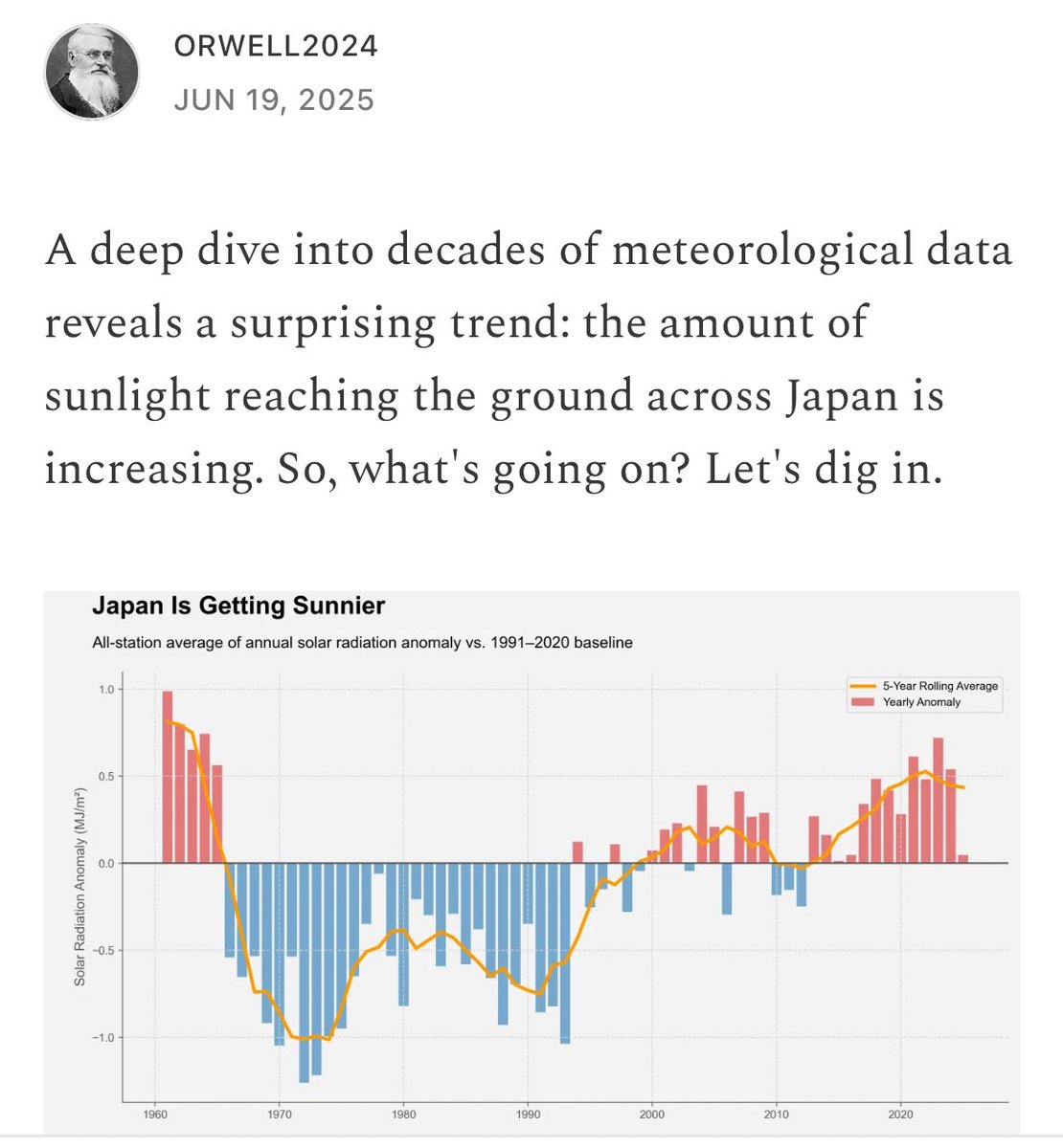
Let's start with Sweden. I also have one more (20/21) data point as compared with Prof. Shahar plot as I work with Sept-Sept.
2/ As a test we overlay.

Note that we have one month different season definitions. Small detail. I used 1st September as it seems to be the historical death minimum over years and countries.
3/ Now let's play. More countries.

And here we start to see interesting things like the disastrous performance of AUT, CH, FR on 20/21 season. Surprised me

We learn: locking down in 19/20 season makes 20/21 explode.

@DrJBhattacharya @MLevitt_NP2013 @MartinKulldorff won 👏🏆
4/ Here again for the "Sweden was wrong" deniers and lockdown fanatics in NL and AUT @rivm @MinPres @hugodejonge @RIVM_vDissel

The last data point is Sept 2020 - Sept 2021

This is how "saving lives" with lockdowns in 2020 (NL and AUT) looks one season later in 20/21. Bad.
5/Summary: the countries with the hardest lockdown approach in 19/20 season like Slovenia (the role model in May 2020 for "eliminating" Covid), had the worst season in 20/21.

Data shows: You cannot escape seasonal death with lockdowns, just postpone with a worse outcome later.
6/ Adding a demonstration of calendar year versus flu year importance:

Example Romania deaths.

Left (calendar year): As we can see, the calendar year artificially splits the 2020/2021 peak in two.

Right (flu year): A much better way to define the year is by flu season.
7/ Doing the analysis by flu season (26 weeks offset), the real tragedy of prolonged lockdowns become very clear on the July 2020 - July 2021 time frame analysis. The excess was explosive in lockdowned countries.

Sweden being right in one picture 👇.
8/ Romania versus Sweden in a picture:

• • •

Missing some Tweet in this thread? You can try to force a refresh
 

Keep Current with Orwell2024🏒

Orwell2024🏒 Profile picture

Stay in touch and get notified when new unrolls are available from this author!

Read all threads

This Thread may be Removed Anytime!

PDF

Twitter may remove this content at anytime! Save it as PDF for later use!

Try unrolling a thread yourself!

how to unroll video
  1. Follow @ThreadReaderApp to mention us!

  2. From a Twitter thread mention us with a keyword "unroll"
@threadreaderapp unroll

Practice here first or read more on our help page!

More from @orwell2022

Sep 10
They're trolling / insulting. The request was clear: compare ERA5 2km / @meteoblue with @AEMET_CValencia sensor at an hourly level. If they match at night, cloudy days, winter, but the sensor shows higher T in summer clear skies / no wind / day 👉 sensor is heat-biased. So? Go.
Thanks, @meteoblue. Normal conversation can be so easy. If the Spanish gentlemen would now provide access to their hourly station dataset, we can overlay it with the fine-grid ERA5 2km hourly product and see what's going on. Does that sound like a way forward @AEMET_CValencia ?

Image
Image
@meteoblue @AEMET_CValencia He clearly doesn’t understand their response nor my request. At this stage, I just want him to provide THE HOURLY DATA. What the answer actually means is that the 30 km cell is more representative of the region’s climate—yes, it’s better than the station. Well done @ChGefaell 👍.

Image
Image
Read 10 tweets
Sep 3
1/ Such places have no credibility for accurate bias free measurements. It's the opposite of a stable environment and per default a diesel powered urban expedition place. We see how the melting starts around the airport and the town.

How to measure? 👉 open.substack.com/pub/orwell2024…


Image
Image
2/ Here we see another example (Alaska). Russian high-lat regions are among the worst. It's a deception to take measurements from such places and claim that you've done 'science' while actually just picking up dirt. Why not Everest dirt basecamp next?
3/ It escalated quickly. Similar to @BMcNoldy from Miami, master's student @Daaanvdb also used airport data instead of professional equipment, like what's available at @UNISvalbard.

Let's do better and use proper data from a better looking station.


Image
Read 19 tweets
Jun 27
1/ As mentioned, Europe is too urbanized for climate measurements. Shown below is just the UHI effect. As mentioned, ANY type of urban landscape altering increases surface temperatures as well. The Netherlands and Benelux regions are all fully biased and unfit for climate science
Image
2/ As mentioned previously, North Sweden is the most credible place for climate measurements due to its development, peace, and ability to capture high-quality data. Besides Sweden, only the US provides reliable historic data. All other regions are not credible and biased today. Image
3/ Source: YCEO Surface Urban Heat Islands: Spatially-Averaged Daytime and Nighttime Intensity for Annual, Summer, and Winter.

It's from 2003. Now it's even more urbanized = worse.

developers.google.com/earth-engine/d…
Read 12 tweets
Jun 18
1/ Remember the scenic document from @NOAA's USCRN. All rural places without man-made objects?


It's 145 pages long, each page one station. They should ALL be there, right?

Nope. How naive to believe that it's done in good faith.

Ready? 🧵 ncei.noaa.gov/pub/data/uscrn…
2/ This finding didn't emerge out of nowhere. Result of me telling @connolly_s that his detailed check of USCRN is a waste of time.

I repeated for weeks...then I swore...

They present the best only and hide urban stations. Bad faith. Consciously.


Image
3/ So, what do they look like, the ones they don't like to show? Urban areas. Airports...

Remember their requirements: It should be like the Everglades. No man-made environmental alterations. Stable. Representative.


Image
Read 12 tweets
May 22
1/ Let's do some checks: Compare the SST data model to water (ground) truth, thermometers in the water.

The green dots are the available @CDIPBuoys, a well maintained network. Probably the best buoy network (by @USACEHQ). Haven't seen any better one.

cdip.ucsd.edu/m/deployment/s…

Image
2/ Florida: the gulf area showing up red at the anomaly chart. The buoy shows nominal at average values. 25C versus +26-27C in the SST model. That's a +1C heat bias. Image
3/ Next - Hawaii. Buoys are below average. SST product is showing heat anomalies there.

14th May: buoy 24.5C vs. 25.5C SST.
+1C heat bias

Interesting. It's apparently too warm, as long as you don't stick a real thermometer into the water to measure and realize: it's cold. Image
Read 7 tweets
May 13
1/ Let's revisit this result from AIRS satellite measurements over 17 years, showing a +0.36W increase in forcing alongside a 40 ppm rise in CO2 concentration.

Does this align with the "observed" (questionable) increase in global temperature anomaly (+0.6C)?

Let’s do a check.
Image
2/The IPCC reports a calculated CO2 forcing of +0.5W, as detailed on the NOAA AGGI page, which you can find here:


The SW calculation overestimates by 40% compared to the +0.36W derived by the AIRS satellite, marking the first significant discrepancy. gml.noaa.gov/aggi/aggi.html
Image
3/ Now we return to Happer's paper, showing that doubling CO2 from 400 --> 800 ppm results in +3W of forcing.


This is consistent with +3.5W reported by the NOAA AGGI (+3.5W).

arxiv.org/pdf/2006.03098

gml.noaa.gov/aggi/aggi.html

Image
Read 7 tweets

Did Thread Reader help you today?

Support us! We are indie developers!


This site is made by just two indie developers on a laptop doing marketing, support and development! Read more about the story.

Become a Premium Member ($3/month or $30/year) and get exclusive features!

Become Premium

Don't want to be a Premium member but still want to support us?

Make a small donation by buying us coffee ($5) or help with server cost ($10)

Donate via Paypal

Or Donate anonymously using crypto!

Ethereum

0xfe58350B80634f60Fa6Dc149a72b4DFbc17D341E copy

Bitcoin

3ATGMxNzCUFzxpMCHL5sWSt4DVtS8UqXpi copy

Thank you for your support!

Follow Us!

:(