Wait for it...
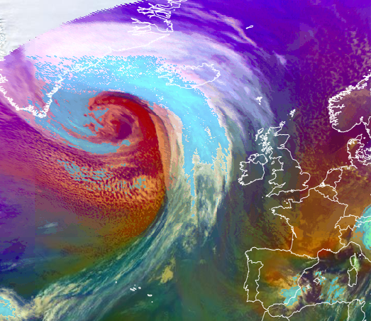
A top-end storm is explosively deepening in the open Atlantic right now. Central pressure should drop below 930 hPa.
The jet stream dynamics are jaw-dropping.
A top-end storm is explosively deepening in the open Atlantic right now. Central pressure should drop below 930 hPa.
The jet stream dynamics are jaw-dropping.
The storm development is linked back to a baroclinic zone over the Southern States. Cold air flooded the USA with strong thermal contrast (very warm to the south).
A beautiful but powerful storm.
A beautiful but powerful storm.
The jet stream interacting with the developing surface cyclone is crucial for such a powerful storm.
The coincidence of the surface cyclone under the 'right entrance' then 'left exit' greatly enhances the cyclone development
A technical link: eumetrain.org/satmanu/four_q…
The coincidence of the surface cyclone under the 'right entrance' then 'left exit' greatly enhances the cyclone development
A technical link: eumetrain.org/satmanu/four_q…

'Explosive cyclogensis' is an actual term used in meteorology. Others may call this a 'weather bomb'.
For a cyclone to be defined as a 'weather bomb', the central pressure must drop by at least 24 hPa in 24 hours.
This storm drops a whopping ~48 hPa in 24 hours.
For a cyclone to be defined as a 'weather bomb', the central pressure must drop by at least 24 hPa in 24 hours.
This storm drops a whopping ~48 hPa in 24 hours.
The storm is massive (spatially). Mid-latitude cyclones like this are far larger in size compared to hurricanes for example. This storm is dragging a lot of cold air east to the south of Greenland.
This snap is from the interactive website by @eumetsat : view.eumetsat.int/productviewer?…
This snap is from the interactive website by @eumetsat : view.eumetsat.int/productviewer?…

• • •
Missing some Tweet in this thread? You can try to
force a refresh


