
There has been a major explosive eruption from Hunga Tonga-Hunga Ha'apai in Tonga. The volcano has been actively erupting since 20 Dec 2021. There are already many news stories and posts about this event. We will add info here to provide context & links.
volcano.si.edu/volcano.cfm?vn…
volcano.si.edu/volcano.cfm?vn…
Very little is known about the evolution of this volcano. The earliest recorded observation of an eruption was in 1912, followed by 1937, and then 1988, 2009, and 2014-15. Those eruptions have all been small, but with so few events there's no good understanding of activity style.
The 1988 eruption was seen by fishermen and a airline pilot, then visited by geologists. It took place from 3 shallow-water vents E of Hunga Ha'apai island, but there was no island built.
volcano.si.edu/showreport.cfm…
volcano.si.edu/showreport.cfm…
The eruption that began on 17 March 2009 had one vent on Hunga Ha'apai and another under water about 100 m offshore. Ejection of tephra filled the gap within a couple days, expanding the size of the island.
volcano.si.edu/showreport.cfm…
volcano.si.edu/showreport.cfm…
After only 4 days the 2009 eruption was over, but had extended the island by 1 km, leaving steaming crater lakes. Pumice rafts were noted near the volcano, and discolored water as the loose material began eroding away.
volcano.si.edu/showreport.cfm…
volcano.si.edu/showreport.cfm…
The next eruption was during 19 Dec 2014-28 Jan 2015. This longer period of activity was centered between the islands of Hunga Tonga and Hunga Ha-apai, and built a new island. Eventually there was so much material that the islands were all connected.
volcano.si.edu/showreport.cfm…
volcano.si.edu/showreport.cfm…
On 20 December 2021 a new eruption produced a steam-rich gas-and-ash plume that rose to 16 km (52,500 ft) altitude. Both lightning and SO2 were detected using remote sensors, along with additional plumes to 12 km.
volcano.si.edu/showreport.cfm…
volcano.si.edu/showreport.cfm…
Notable activity continued through 28 December, including more gas-and-steam plumes with diffuse ash up to 12 km. A Tonga Navy crew saw explosions ejecting tephra 350 m into the air. Most ashfall was close to the volcano.
volcano.si.edu/showreport.cfm…
volcano.si.edu/showreport.cfm…
Eruptive activity continued through 3 January 2022, but had decreased overall. Discolored water and pumice rafts remained around the island. On 31 Dec the steam-and-gas portion of the plume rose as high as 18 km (59,000 ft) altitude.
volcano.si.edu/showreport.cfm…
volcano.si.edu/showreport.cfm…
You may see terms like "hydromagmatic" or "Surtseyan" in media or scientific reports. That just means that magma is interacting with water to produce some distinct types of explosions. This photo gallery has more explanation and examples. Click the images!
volcano.si.edu/gallery/ImageC…
volcano.si.edu/gallery/ImageC…
There are still a lot of unknowns in the details of this eruption, but one or more vents are either shallow submarine (just under the ocean surface) or on the island itself. That means that there is a lot of water being turned to steam, and the amount of volcanic ash isn't clear.
People like to speculate about the Volcanic Explosivity Index (VEI). But knowing that number really isn't important now, and is hard to calculate until we know more about the volume of ash and confirm some of the altitudes. Yes, it's big, but possible impacts are uncertain.
Another point to remember about the VEI is that it applies to an individual eruption, not to the volcano. Knowing that past eruptions have been large or small is useful for hazard assessment, certainly, but must be used with careful understanding.
Some reports are already misunderstanding and saying that this was a "VEI 2" volcano. The few eruptions seen in the past 110 years were max 2, but it's a large caldera system! It would not be a surprise to find evidence of previous very large eruptions there.
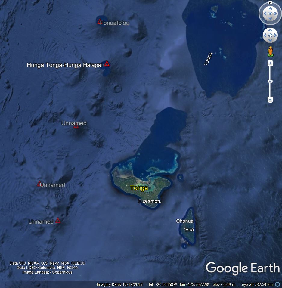
For a bit of geography, this view in Google Earth shows the larger island of Tongatapu about 60 km / 40 miles south of the Hunga Tonga-Hunga Ha'apai volcano. Tongatapu is 700 km SE of Fiji and 2,000 km NE of New Zealand/Aotearoa. 
The term "caldera system" was in a previous post, but what does that mean? As a start, we have another image gallery with some beautiful examples of calderas, including a good working definition at the top of the page. Take a few minutes to browse there.
volcano.si.edu/gallery/ImageC…
volcano.si.edu/gallery/ImageC…
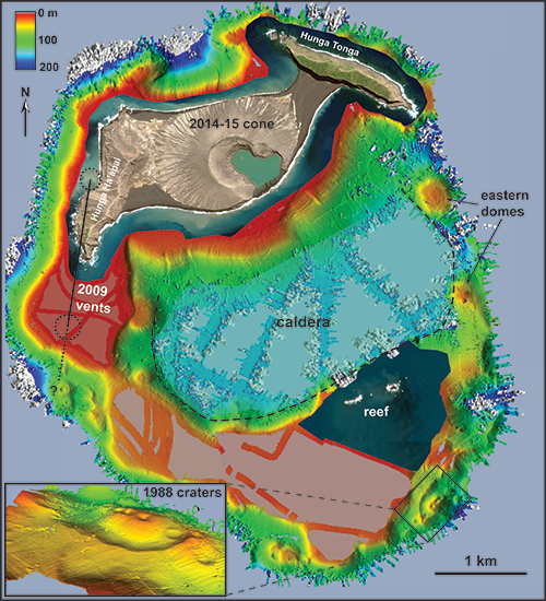
Submarine calderas are harder to see. However, a bathymetric map was published in a paper by James Garvin and colleagues (Open Access) following the 2015 eruption. The research involved high-resolution satellite imaging over ~30 months after the eruption.
agupubs.onlinelibrary.wiley.com/doi/10.1002/20…
agupubs.onlinelibrary.wiley.com/doi/10.1002/20…
That map, created with April 2016 data from the R/V Falkor, showed details of the overall volcanic edifice. Measured on this quick Google Earth overlay, the diameter of the caldera rim is ~6 km. Recent eruptions have been on the N and NE sides. Red * is 2009 vent.

Fieldwork by Shane Cronin (@scronin70) and colleagues was briefly reported in EOS in 2017. They found welded pumice-rich ignimbrite and nonwelded pyroclastic flow deposits from past "huge explosive eruptions" -- one maybe as recent as 900 years ago.
doi.org/10.1029/2017EO…
doi.org/10.1029/2017EO…
As part of that research effort the caldera was mapped at 1-m resolution. A chain of vents from the 1988 activity, on the SE side of the caldera, can be seen in that data.
While the entire volcanological community hopes that the people of Tonga have remained safe, it is still our job to learn from this event and report what we know, and don't know. There are certainly some unique features of this explosion and new technology watching it.
With this eruption happening in daylight, the images available in standard visible satellite images were quite impressive, showing the eruption plume penetrating into the atmosphere. Simon Proud (@simon_sat) made a great compilation video.
https://twitter.com/simon_sat/status/1482412149897142284
What was the situation before the big eruption though? There had been many earlier explosions, including a large event about a day earlier. @planet imagery showed the 2014-15 central island was already gone, as seen in this collection by @tanyaofmars.
https://twitter.com/tanyaofmars/status/1482426851226230784
Seeing through the clouds and plume remnants, radar images from #Sentinel1, with 3 passes animated by @ThomasOrmston, revealed that there are still small remaining pieces of the older two islands.
https://twitter.com/ThomasOrmston/status/1482449626460565506
• • •
Missing some Tweet in this thread? You can try to
force a refresh


