#ONStorm#ONwx After reviewing the latest high-resolution data this evening, we're becoming quite concerned about the GTA around Lake Ontario into Eastern Ontario.
Models are showing intense snowfall rates of 5-10cm PER HOUR (yes, that's in one hour).
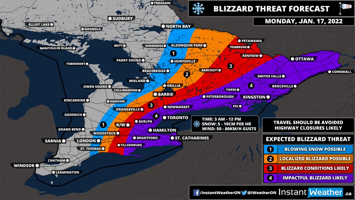
Combined with wind gusts approaching 50-80km/h will lead to potentially dangerous blizzard conditions along the Lake Ontario shoreline and parts of Eastern Ontario. The worst conditions will start around 3 am and continue until noon.
If possible, you should avoid any non-essential travel through the affected area until at least the late afternoon. Highway and road closures are likely even for some major highways in the GTA, Niagara region and Eastern Ontario.
We don't like using words this extreme, but we want to get across that unless you're an essential work, PLEASE avoid travel in the morning. It's not worth the risk and the chance of getting stranded for hours.
This will be one serious storm. Maybe one to remember for years to come. Just stay home and be safe!
The snow has started to make its way into our region late this evening. We are also seeing this very sharp gradient setting up on the northwestern edge of the system.
This is why we had so much uncertainty with the expected accumulation in this area. You can see that London is currently under a very intense band of snow but just a few kilometers to the northwest and there’s barely a flake.
At this point, it looks like our forecast is lining up fairly good based on the current radar. The snow has started a little earlier than expected but that shouldn’t affect the actual totals.
NOTE: School boards have already started announcing cancellations tonight. We will keep an updated list of cancellations within the snow day forecast.
If there are any cancellations tomorrow morning, you can be sure we’ll be up bright and early beginning at 6 AM with our bus cancellations live blog to keep you updated.
#ONStorm#ONwx UPDATE: Monday’s Snowstorm Shifts Further West Bringing the Threat of 20+cm of Snow Into the GTA and Central Ontario; Up to 50cm of Snow Possible for Niagara and Eastern Ontario
Once again, we ask you to please *read* the entire forecast as many of your questions and concerns will be answered there. This is a very complex system and just reading the headline or looking at the map won't be that helpful.
We included lots of details about what could happen along with a detailed timeline graphic for each region. Taking that 5-10 minutes to read the forecast is a worthwhile investment to ensure you're properly informed.
#ONStorm#ONwx You may have seen a 'storm chip' forecast circulating on social media for the Maritimes.
We've had many requests from the community to bring the storm chip forecast to Ontario. So we've done just that... introducing our first 'Storm Chips & Hot Cocoa' forecast!
Clearly, this isn't meant to be a scientific forecast by any means. Storm chips tend to be more of an Atlantic Canada tradition, however, it appears to be catching on here. We figured why not put out something a little more light-hearted to ease the stress of this snowstorm.
We aim to be a family-friendly page so we used a drink that everyone of all different ages (including children) can legally enjoy. But for those who need something a little stronger to get through this, feel free to convert it to your preferred adult drink. ;)
We’ve been continuously going over the latest data for the significant snowstorm affecting Southern Ontario late tonight into Monday.
The models continue to trend with a slightly more western track which means higher snowfall totals are possible. Those in our ‘uncertain’ zone will likely see more snow than shown on our map from last night (included in the tweet).
As we mentioned, this area has a very tight gradient between no snow and very heavy snow so changes are expected.
We’re looking at bumping the Hamilton, Toronto and Kawartha Lakes region up to the 25-40cm range on our map.
#ONStorm#ONwx Potentially Strongest Snowstorm in Years To Bring Up to 20-40cm of Snow to Parts of Southern Ontario Starting Sunday Night; Localized Blizzard Conditions Possible Monday Morning
It's very important to *read* the entire forecast instead of just focusing on the map. There are a lot of variables with this system in particular which makes it very difficult to forecast.
Our goal remains to keep you informed on all the potential outcomes which can't be shown in one single map. We have also included our detailed timeline graphics to help you know when to expect the worst conditions.