Update Thread:
#ExtremeWeather #Madagascar #Batsirai #CycloneBatsirai
Intense Cyclone Batsirai has strengthened rapidly and grown significantly larger. It has now passed Mauritius and its outer bands are now over Reunion.
#ExtremeWeather #Madagascar #Batsirai #CycloneBatsirai
Intense Cyclone Batsirai has strengthened rapidly and grown significantly larger. It has now passed Mauritius and its outer bands are now over Reunion.
Madagascar is 1000kms long top to bottom and #BatsiraiCyclone's outer bands are roughly the same size. With sustained winds of over 113 knots the storm is now the equivalent of a Category 4 Major Hurricane. 

The JTWC's latest forecast track update #13 shows the storm maintaining very intense cyclone intensity up to landfall (of the eyewall - maximum strength winds) in the morning on Saturday. Rain and high winds will arrive on Friday. 

The PWAT forecast data from the ECMWF model suggests #Batsirai will cover the entire Island as it passes over and while its sustained winds will reduce sharply on landfall, will remain intact as it crosses the island's on a trajectory covering roughly 340kms. 


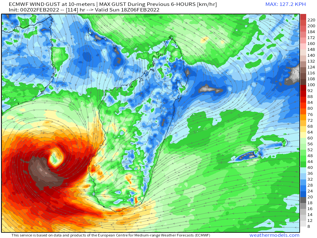
This ECMWF forecast shows the eye of the Cyclone open shortly after it reaches the Mozambique Channel. If possible it may be advisable for all in the direct path of this cyclone to get out of its way.
Arrival time on the East Coast is at present still two days away and #Batsirai is forecast to take a further two days to cross the Island. The Hurricane will not weaken on arrival as it will maintain a significant footprint over warm ocean water whilst making its transit.
In rain terms this is the latest ECMWF rainfall simulation for #Batsirai, more than 500kms of the East Coast and areas adjacent to roughly 100kms inland are expected to receive over 400+ mm of rain in the first 36 hours.
And rain continues through the forecast period.
And rain continues through the forecast period.
This Precipitable Water animation explains why. This is a worse case storm scenario. A slow moving super cyclone such as #Batsirai generates massive amounts of airborne water - and as it approaches Africa there is already a lot of moisture due to it being monsoon season.
This animation shows half the rainfall in 6hrly snapshots (every second one is dropped). Effectively #Batsirai floods the zone and so rain continues over Madagascar after it passes.
This version of the same data - now with all the rain shows the accumulated rainfall totals. A southern Mozambique landfall is currently forecast in a week on Feb 8th, delivering very similar, catastrophic levels of rain.
#Batsirai's current forecast path then takes it south west over Maputo the capital of Mozambique, Eswatini, and into North Eastern South Africa. Modelling suggests the storm may follow the coast southwards at that point - but cyclones, especially strong ones, are unpredictable. 


This unpredictability is apparent in today's significant strengthening of #Batsirai, the storm had been forecast to weaken as it approached Madagscar.
• • •
Missing some Tweet in this thread? You can try to
force a refresh


