Alastair Thompson Profile picture
Feb 5, 2022 14 tweets 9 min read Read on X
#Batsirai #ExtremeWeather Update Thread:

Cyclone Batsirai is weakening and accelerating on its final approach to Madagascar's East Coast. But while lower winds will be helpful - it's primary impact - widespread very heavy rain - is likely to be extreme.
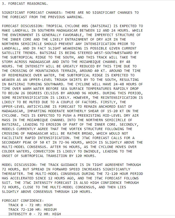
The official forecast has not been updated, the eyewall landfall (diminished by the filling of the eye) is likely to take place a little later than forecast but wind and rain is already building over the island as is obvious in the satellite imagery.
As of 20 minutes ago the center of the cyclone had roughly 100kms to travel to the shoreline. It will a bring a significant tidal surge with it, especially on the southern side and likely cause significant coastal flooding over a large area of the coastline.
This animation shows satellite estimated rainfall from @Meteoblue over the same 12 hour period as show in the animation in the original post at the top. Rain impacts ahead of the cyclone are already intense.
Here's the latest satellite radar rain image for #Batsirai which shows the leading rain band approaching the capital Antsirabe (population 250k) in which 80 people were killed during Storm Ana by flooding just over a week ago. This storm however is an order of magnitude larger.
In this image its apparent how large the full force wind field will be at landfall. This animation shows 10 wind gust speeds over the coming four days during the course of the cyclone's intense impacts on the Island of nearly 30 million people.
Madagascar is 1000kms long and the most populated areas re forecast to be most effected by the cyclone. The population is mostly rural and agrarian.

The area of most intense heavy rainfall near the coast is roughly 67k km2 - 3/4 the size of the Irish Republic.
This 96 hour animation shows the Euro ECMWF's modelling of the timing of rain. The rain shown in the first frame has already mostly fallen, and the most intense rainfall is forecast to end by midnight Sunday.
Here are the first four frames in that animation (each showing 6 hours of rainfall) taking us to 6pm tomorrow.
These are the next three frames showing that the intense rain part of this will be over by midnight tomorrow.
This animation shows the atmospheric water trail being generated by and accompanying the storm. From the presentation following exit over the Mozambique channel it is apparent only a tiny fraction of this water will fall as rain.
And our final plot shows the latest accumulating rainfall totals. And we can see here that the southern drought effected area is expected to get significant rain, and mostly in quantities that ought not to cayse massive flooding.
To conclude this update yesterday's @UNGeneva briefing began with a briefing from the @WMO #OCHA and @WFP about its preparations to assist Madagascar in the cleanup and humanitarian mission which is expected to follow the storm.

Watch here >> media.un.org/en/asset/k1a/k…
/ENDS

@Threadreaderapp unroll

• • •

Missing some Tweet in this thread? You can try to force a refresh
 

Keep Current with Alastair Thompson

Alastair Thompson Profile picture

Stay in touch and get notified when new unrolls are available from this author!

Read all threads

This Thread may be Removed Anytime!

PDF

Twitter may remove this content at anytime! Save it as PDF for later use!

Try unrolling a thread yourself!

how to unroll video
  1. Follow @ThreadReaderApp to mention us!

  2. From a Twitter thread mention us with a keyword "unroll"
@threadreaderapp unroll

Practice here first or read more on our help page!

More from @althecat

Jul 21
THREAD: Some thoughts on October 7th and the importance of their being global transparency over what we know about what really happened on that terrible day.

1/ This (see screenshots in the first few posts in this thread) is one of the most important pieces of conflict related journalism published in recent years.

It relates to the orders given to soldiers on October 7th to fire on any vehicle seeking to return to the Gaza Strip to prevent the taking of hostages and was published on July 7th, 10 months later in Haaretz.Image
2/ As @IsraeliPM Benjamin Netanyahu prepares to address congress it is vital that the public in the US, Israel and globally is fully aware of what exactly happened on October 7th in Gaza. Image
3/ The account in this story published by Haaretz is at this time still behind a paywall and it has therefore not been read by the very large number of people who ought to have done so. I have not seen very many reports containing the detail of this report elsewhere though I presume there are many.

A copy of the report can be found however on here >> Archive.is
archive.md/zqUntImage
Read 16 tweets
Jul 8
OK so clearly #HurricaneBeryl is not the same as #HurricaneHarvey. But there are some striking similarities in terms of what has made it so much more persistent than either forecast or as modeled.

This thread is going to look at this issue a bit more deeply.
- The overall cloud mass of the #HurricaneBeryl thunderstorm complex proved much more resilient than expected once it came over land. Why?
- Also Like #Harvey Beryl did slow down after making landfall and continued to spin over land. Why?
- I think the answer to both questions relates to the very warm waters of the Gulf of Mexico. Like Harvey back in 2017, Beryl has been fueled by a constant stream of warm wet atmospheric flows of energy off of the Gulf of Mexico.
- This is obvious in part simply from observing the astonishing expansion of the cloud field after #Beryl made landfall early this morning.

A clue to understanding this can be found in looking at the the astonishing growth progression of #HurricaneBeryl's cloud field over landafter Beryl strengthened and formed itself into a Hurricane in the period after making landfall south of Houston.

Over the course of the rest of the morning you can see in these images how much the wind field expanded.
Like Harvey #Beryl also grew and strengthened itself by feeding off of the gulf of mexico, specifically the area between the Texas coastline and what looks like the outer boundary of the convection field which expanded extremely strongly to the north.

The only source for all this additional atmospheric moisture can be the oceanic convection which took place in what is a fairly clearly bounded 136,000 km2 area of ocean which as you can see in this animation is very closely bound to the rest of the circulation.

This is a much much larger area than the area of active rainfall which settled over the city and metropolis of Houston for the morning and which is finally starting to move off to the north now.
This version of the graphic shows the comparative sizes of the area of water which is responsible for the astonitising growth of post landfall #HurricaneBeryl - and the area of the storm that remained over the ocean and which is almost certainly responsible for both why this storm was so persistent and why it (like Harvey) slowed down after coming ashore.
Read 4 tweets
Jul 8
#HurricaneBerylis not expected to give up lightly as it moves onshore and turns north eastward over Texas and then heads north east across the great planes towards the great lakes.

Typically we expect hurricanes to weaken rapidly over land - especially wind wise. But #Berylis not forecast to behave as normal - probably because like Harvey, its tail over the Gulf is keeping it fueled. - the currently forecast pattern from Fox News's exclusive model shown in these images was present in some of the simulations of Beryl after it crossed the Yucutan a couple of days ago.

To my mind questions ought to be asked about the accuracy of the forecasting for this storm, as - like the last super destructive Texas Hurricane, Harvey in 2017 [] Beryl is proving to be a LOT more destructive in its impacts than initially forecast.en.wikipedia.org/wiki/Hurricane…Image
Image
Image
Image
The final image in this sequence of screenshots of Fox Weather Graphics is worth drawing attention to as it shows how much broader the impacts of this hurricane are expected to be as it moves across the great planes roughly speaking heading up the Mississippi river, and continuing to dump potential flooding rain as it goes.Image
This image shows the forecast expected severe weather threat from the remnants of #HurricaneBeryl in Arkansas and Missouri up as far as Saint Louis. Image
Read 6 tweets
Jul 8
ALERT: High Target News Environment in play - numerous consequential news events with global implications.

1. British elections - (Thursday July 4th-Friday July 5th): Delivering an unprecedented landslide win to the left's @UKLabour Party + strong showings for the Liberals and Greens . The UK Chancellor @RachelReevesMP will shortly set out her economic policy in a speech.

2. French elections (Sunday July 7th) deliver a remarkable 2nd big win for the left in politics in France - dashing the hopes of Marine le Pen's hard right wing "Rassemblement National" of first parliamentary victory

3. Overnight (7th-8th July): an unprecedented huge Hurricane , #Hurricane Beryl - makes landfall in Houston as a Category 1 Hurricane, its main threat to the epicenter of the global fossil fuel industry will be flooding. It is still night in Houston at present.
You can watch the new UK Chancellor's speech live here now >> youtube.com/live/oJUvTVdTM…
English language coverage of the French Election from @France24_en can be watched here >>
Read 5 tweets
Jul 1
Hmmmmmm…. Why is the audio of the @youtube version of the UNSG office daily briefing for 1st July missing sound from 5:24 to 6:07?

Afghanistan, Lebanon, Myanmar & other topics - Daily Press Briefing (1 J... via @YouTube

Image
Image
The content of this portion is available as it is simply a quote from written remarks of UNSG @antonioguterres made to a meeting in Austria. But the missing YouTube audio is unprecedented in my experience and hard to explain.
Video from the un platform is here. webtv.un.org/en/asset/k12/k…
Read 10 tweets
Jun 23
Another day. Another Israeli
war crime.

Intense bombing by Israeli forces on Gaza continues and kills at least 3... via @YouTube
This report also addresses the widening rift between Israeli PM Netanyahu and the U.S. Government. True to form Netanyahu is showing no sign of backing down. But this tweet showing former Defence Minister Yoav Gallant leaving on a U.S. flight for the U.S. speaks volumes in this very intense moment.

Amidst continued bombing of Rafah, Israeli forces are resuming strikes i... via @YouTube
And here from two days ago more Margaret Brennan context on the rupture in relations between the @WhiteHouse and @IsraeliPM

Israel has not come close to destroying Hamas, U.S. official says via @YouTube
Read 7 tweets

Did Thread Reader help you today?

Support us! We are indie developers!


This site is made by just two indie developers on a laptop doing marketing, support and development! Read more about the story.

Become a Premium Member ($3/month or $30/year) and get exclusive features!

Become Premium

Don't want to be a Premium member but still want to support us?

Make a small donation by buying us coffee ($5) or help with server cost ($10)

Donate via Paypal

Or Donate anonymously using crypto!

Ethereum

0xfe58350B80634f60Fa6Dc149a72b4DFbc17D341E copy

Bitcoin

3ATGMxNzCUFzxpMCHL5sWSt4DVtS8UqXpi copy

Thank you for your support!

Follow Us!

:(