
#Batsirai #ExtremeWeather Update Thread 6:
The center of Intense Cyclone Batsirai has nearly completed its crossing of Madagascar but the storm/wind field continues to impact the southern half of the island.
The center of Intense Cyclone Batsirai has nearly completed its crossing of Madagascar but the storm/wind field continues to impact the southern half of the island.
https://twitter.com/althecat/status/1489944002841432067
The most intense rainfall was concentrated near the Capital City Antisirabe, the 4th largest city moving slowly. Extreme flooding in this area appears likely. And there were two additional extreme rainfall events in the North and the West of the island, fueled by the storm.
We see in this image that the eye of the storm (with its most damaging winds) remained intact for several hours after landfall finally losing its structure in the early hours Sunday Morning.
The lightning display as seen in satellite imagery during this period is extraordinary.
The lightning display as seen in satellite imagery during this period is extraordinary.
Over the next five hours you can see the intensity dropped but the circulation itself remained very intact. The rain animation above from @Meteoblue suggests rainfall was much reduced during this period.
@meteoblue Over the last six hours forward motion has slowed as the storm begins to reorganise itself with strong convection over the Mozambique Channel in the upper left here.
Here we can see the rain also picking up in the North Western Quadrant. This suggests the storm may be already re-strengthening.
A satellite view of this same 6 hour period.
Here we can see the atmospheric aftermath of #Batsirai, having generated so much moisture this moisture now needs to be either fall as rain or move somewhere else. This is a 16 day animation and it shows the moisture moving East and some returning as two more cyclones.
This IVT (Water Vapour Transport) forecast provides a clearer view of what is expected to happen. But bear in mind (as we have seen with #Batsirai) that cyclones are unpredictable, so this is just one of multiple possible scenarios.
TL/DR Madagascar is not yet out of the woods.
TL/DR Madagascar is not yet out of the woods.
As #Batsirai was passing over Madagascar the first of the cyclones which you see towards the end of the animations above - Tropical Cyclone Cliff formed in the Indian Ocean, going through a process called Cyclone Genesis - which you can see below.
The experts in this process are the team at the Joint Typhoon Warning Center [metoc.navy.mil/jtwc/jtwc.html] in the @USNavy who coordinate cyclone warnings globally. 

What is now Cyclone Cliff was designated as a disturbance of interest (sometimes called a tropical wave) on February 2nd. When updates are posted by the JTWC they also provide forecast/reasoning statements like this.


In addition the computer models which produce the charts which I post in these threads simulate the development of these storms from which constantly updated charts like these are produced which provide us with long range warning of possible cyclones.

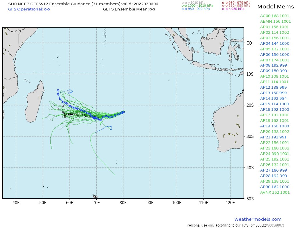
The latest GFS simulation model run for the South Indian Ocean posted earlier the this thread and quoted below shows a outcome that does not threaten Madagascar. But as cyclones are very unpredictable a close eye will need to be kept on this storm.
https://twitter.com/althecat/status/1490354240996446209?s=20&t=C3mkB3Sypn9ok3ovOvmDsQ
At the moment the "GEFS ensemble mean" suggests that this storm does pose a threat to Madagascar. TC Cliff has the possibility of becoming an Intense Cyclone similar in strength and possibly larger than #CycloneBatsirai

/ENDS
@Threadreaderapp unroll
@Threadreaderapp unroll
• • •
Missing some Tweet in this thread? You can try to
force a refresh


