
A lot of footage is being posted online of Russian military movements along the Ukrainian border. We’re working with the #OSINT community to document, verify & map this information. You can find our map of verified movements here: maphub.net/Cen4infoRes/ru…
How do we verify this information? We use simple open source techniques such as imagery analysis & geolocation to confirm where, when and what is in the footage. For example, this is one of the videos we have verified:
https://twitter.com/GirkinGirkin/status/1484837416959627267?s=20&t=2SCFh-Ohbkw9DfEB3_vhnw
How did we find the location? Well, the name in the original tweet is a starting point, but proving exactly where it was filmed is a bit more tricky. For this, we use Google Maps & Google Earth to match features seen in the footage. 
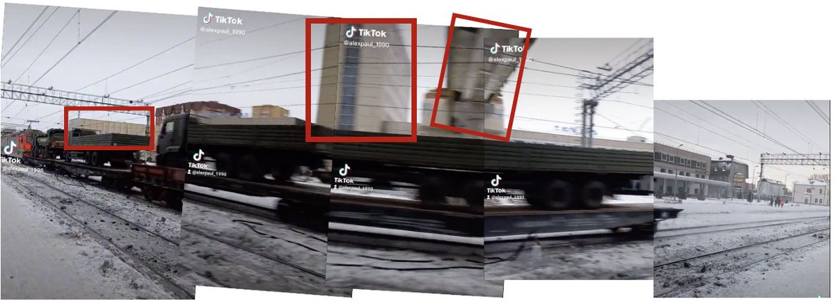
We can cross-reference stills from the footage to satellite imagery to confirm this video was indeed taken in the town and filmed from this exact location.

There is a whole community of researchers, journalists, investigators and geolocators watching these movements, so we’re linking out to the source of that verification in the map as well.
Map: maphub.net/Cen4infoRes/ru…
Map: maphub.net/Cen4infoRes/ru…


Footage from social media showed multiple Iskender missile systems allegedly arriving in Asipovicky. Our Investigators were able to geolocate the footage, taken on January 20, to the Asipovicky train station.
https://twitter.com/MotolkoHelp/status/1484482329452204032

An image showed the Iskander missile systems after they had been unloaded, allegedly in Asipovicky. Our Investigators were able to geolocate the image, taken on January 21, to a train yard just outside of the Asipovicky train station.
https://twitter.com/MotolkoHelp/status/1484446475773960192

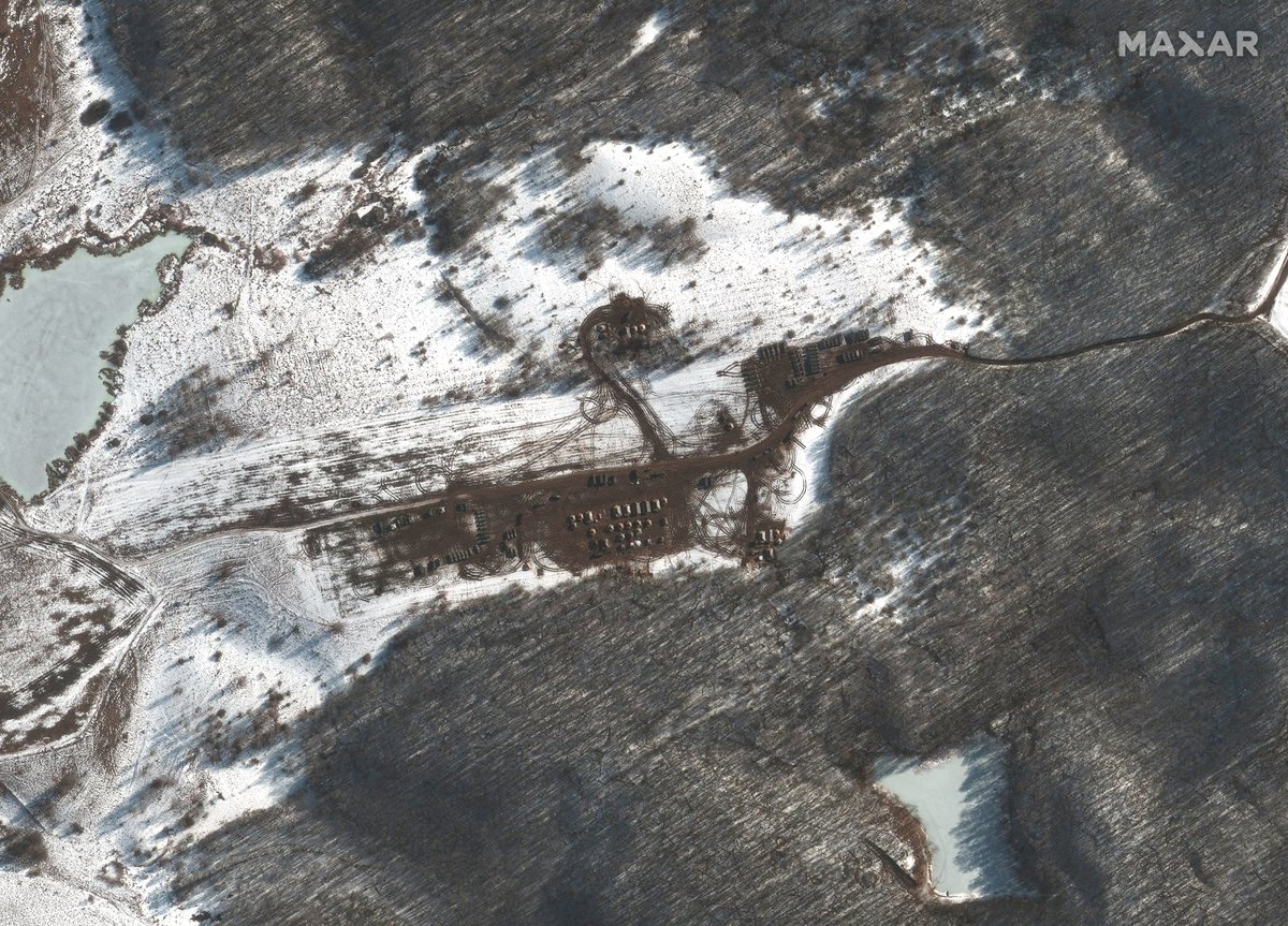
The presence of the Iskander was later confirmed via satellite imagery from @Maxar, showing a large number of 9K720 ‘Iskander’ mobile short-range ballistic missile systems gathered at Asipovicky training ground, January 30 in Belarus. Location: goo.gl/maps/pCwveZPJY….

We now have 153 entries on our Russia-Ukraine Monitor Map thanks to the crowdsourced verification and footage uploaded by civilians and verified by our team. Here is the link: maphub.net/Cen4infoRes/ru….

Geolocation of helicopters near Belgorod (Белгород) 40km north of Ukraine border. Same place seen on Yandex Street View here: yandex.com/maps/4/belgoro…. H/T @hengenahm for geolocation.
https://twitter.com/GirkinGirkin/status/1492707422938533888?s=20&t=2kX14FF-_Oc1pOZgg4XUtA

Helicopters were also seen at the same area near Belgorod in this footage shared by @GirkinGirkin.
https://twitter.com/GirkinGirkin/status/1492599809320144896?s=20&t=pjLW77zCcn7g5b4MNLKO9w

@GirkinGirkin Heavy military equipment spotted close to Maslovka Station in Voronezh (Воронеж). We have geolocated the tanks using further footage from the same location.
https://twitter.com/GirkinGirkin/status/1492213193250324487?s=20&t=Way6SJG8A-nRyqCcDMgjrgH/T to @gfusfus for the geolocation.

We have geolocated part of the footage claiming to show the withdrawal of Russian forces to Bakhchisaray train station, Crimea [180KM from mainland Ukraine]. The view can be seen here on Yandex Street View: yandex.com/maps/27217/bah…
https://twitter.com/RT_com/status/1493511719813062656?s=20&t=pqQN8VfmjNtnne3qgUJ7IQ


Footage showing S-300V missile tubes, launcher and transport vehicles geolocated to Veselaya Lopan', Belgorod Oblast, 20KM from the border with Ukraine h/t @Idzanagi4
https://mobile.twitter.com/worldonalert/status/1493633308869410816

Further footage claimed to be of today, showing S-300 series surface-to-air missile launchers, geolocated to Kursk train station. h/t @zvalgasrytuose
https://twitter.com/KyleJGlen/status/1494258304788443136

Open source analysis from @bellingcat's @EliotHiggins on the shelling of a kindergarten in Stanytsia Luhanska in Eastern Ukraine today
https://twitter.com/EliotHiggins/status/1494233592913879041?s=20&t=5NgKSA0Z9__3XbSpYXZGTw.
Russian 2S19 Msta-S Self-Propelled Howitzer spotted earlier today in Kazinka, Valuysky District, Belgorod Oblast (17KM from the border with Ukraine)
https://twitter.com/4emberlen/status/1494362768241315840

Geolocation of convoy moving south along P31 highway. This is the location of the roundabout where the footage was filmed: 53.012621, 29.208257.
https://twitter.com/MotolkoHelp/status/1494668118320373762?s=20&t=crJerk9ZMaK7KH0x6i5PTw
Geolocation of military equipment moving south in the town of Kirov, Belarus [51.511860, 29.424702, 14 KM from the border with Ukraine]
https://twitter.com/MotolkoHelp/status/1494667171972141061?s=20&t=UzEa7DDbIeLu9x-PMSjvIw

Geolocation of the explosion that took place in central Donetsk tonight: 48.009987, 37.800718
https://twitter.com/AricToler/status/1494709013740675072

Geolocation of military convoy in Southern Belarus [51.783850, 29.484522]
https://twitter.com/GirkinGirkin/status/1494733116417716225

Military convoy geolocated heading west in Yevpatoriya, Crimea [45.210692, 33.366481]
https://twitter.com/GirkinGirkin/status/1494733367597805569

Tanks moving north west, 15km from the border in Chaiki, Belgorod Oblast [50.504112, 36.270381] h/t @ruggerz
https://twitter.com/GirkinGirkin/status/1495471310159421443

@ruggerz Geolocation of Rosgvardia convoy heading south in Sanyuki, Belarus. 20km from the border with Ukraine [51.843593, 29.220673]
https://twitter.com/MotolkoHelp/status/1495731393854427137

We have now updated our Russia-Ukraine Monitor map to include verified footage right up until Feb 21. This means we now have just over 410 entries on our map showing force buildups and locations of specific equipment along Ukraine's border. maphub.net/Cen4infoRes/ru…


Fire at the Luhansk Power Station on Schastia. Location: 48.745841, 39.262668
We are seeing reports online of a number of important accounts in the verification and open source community that have been posting about Russia & Ukraine locked out of their accounts on Twitter.
https://twitter.com/COUPSURE/status/1496405615098400774?s=20&t=lYmh2hd3EO-MNTKKHWV1nA
https://twitter.com/Osinttechnical/status/1496420043223191555?s=20&t=4LY3VNecNzOekYHL7YGUtw
https://twitter.com/AuroraIntel/status/1496418136567992320?s=20&t=Rxg0-ZXbguGzNbsml8OisQ
Many of these accounts are integral to the crowdsourced verification and combatting of false narratives in Ukraine, not to mention a core resource for journalists, researchers and policy makers.
https://twitter.com/Osinttechnical/status/1496420043223191555?s=20&t=4LY3VNecNzOekYHL7YGUtw
Location of recent satellite imagery from @Maxar showing buildup at the aerodrome near Mazyr (Мазыр), located here: 51.985890, 29.160549
https://twitter.com/Mike_Eckel/status/1496356475702235141?s=20&t=sR8tQB6ZZN7XpbwZs2peMg


Location of @Maxar imagery showing buildup point just near Ugrim (Угрим) in Belogrod Oblast. Location: 50.524185, 36.361644. Note that this location is within 20km of the border with Ukraine.

@Maxar Location of recent @Maxar imagery showing a new field hospital just outside of Belogorod (Белгород) 50.649803, 36.527582
https://twitter.com/COUPSURE/status/1495778529593761796?s=20&t=0HdOsAmqBTjkAHtHQIW7SQ


@Maxar Explosions in the outskirts of Kharkiv [filmed at 49.990083, 36.359339]
https://twitter.com/ELINTNews/status/1496705653422895108/video/1


@Maxar Explosion around Ivano-Frankivsk airport [filmed at 48.906787, 24.712699]
https://twitter.com/NewsX/status/1496729252795928578


@Maxar Geolocation of missile hit around Ivano-Frankivsk airport [filmed from 48.897141, 24.715258]
https://twitter.com/BNONews/status/1496738880749727755


@Maxar Geolocation of casualty in Uman, Cherkasy Oblast [48.748716, 30.218705] [Graphic:
https://twitter.com/zyundex/status/1496735074720563203?s=21]

@Maxar Geolocation of artillery strike on a hospital in Ukrainian-controlled Vuhledar, Donetsk oblast [47.775284253726696, 37.23941966817724]
https://twitter.com/Volnovakha/status/1496789425287839746

We are going through the large volume of footage coming out of Ukraine today and adding it to the map. There is some graphic footage, so please read the descriptions before viewing any of the linked footage. maphub.net/Cen4infoRes/ru…


Geolocation of helicopters flying over Gostomel [50.583768, 30.254727]
https://twitter.com/DeanoBeano1/status/1496806993448902658

Geolocation of "LNR" press video showing a pontoon bridge over Seversky Donets river [48.647527834212745, 39.038607760990324]

Geolocation of helicopters moving in the direction of Hostomel airport [approximate location of helicopters: 50.597407, 30.479242]
https://twitter.com/AuroraIntel/status/1496814717964324865

This footage is not Ukraine. This is from Syria.
https://twitter.com/nexta_tv/status/1496846868755542016?s=20&t=8Uye7au6G7fraQx08pgc2w


Gunfire in the streets of Okhtyrka, Sumy Oblast [50.309070, 34.878152]
https://twitter.com/BabakTaghvaee/status/1496882689261068296

Russian troops seen crossing the Dnieper river at the Antonivka suburb of Kherson city.[46.678419, 32.719509]
https://twitter.com/aldin_ww/status/1496853954558320642

Geolocation of footage of destroyed bridge from today just outside of Kyiv, in Vyshhorod (Вишгород). Location: 50.584189, 30.543134
https://twitter.com/RALee85/status/1497158075723264001?s=20&t=xjxOOEclRmRjB3V1HOgNjQ

Geolocation of large explosion this evening at strategic fuel reserve in the Kulynychi district of Kharkiv. Location: 49.96774946311656, 36.39880562604079

Geolocation of footage showing heavy fighting in Melitopol in Zaporizhia Oblast, Ukraine. The building attached is marked on its front as a hospital and the building seen is listed on Google Maps as the Oncology Center. Location: 46.839817, 35.371137.
https://twitter.com/nexta_tv/status/1497240135615791107?s=20&t=8St4mdEuwhWE1ZmDoKaUUA

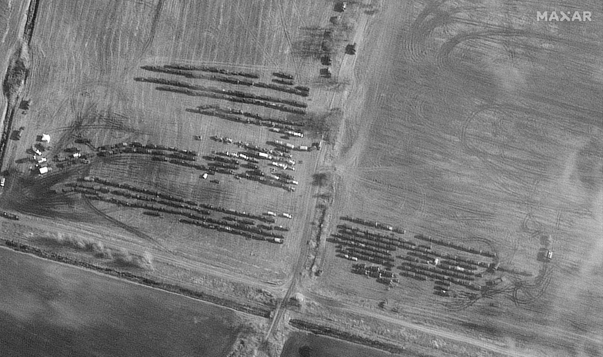
Very concerning development seeing the buildup of new forces today from @Maxar satellite imagery.
A public road south east of Chojniki in Belarus has been blocked off and turned into space for a long line of helicopters. This is 150km north of Kyiv. Loc: 51.824667, 30.071583
A public road south east of Chojniki in Belarus has been blocked off and turned into space for a long line of helicopters. This is 150km north of Kyiv. Loc: 51.824667, 30.071583


Just near the location above where the helicopters have staged near Ukraine's border is a new large deployment of ground forces with several hundred vehicles in fields seen in convoy position.

One of the important indications is what we see in @Maxar imagery at Bokov airfield, 40km from the border in Belarus. There is a significant increase of troops and large number of helicopters seen on the runway. Location: 51.985890, 29.160549


@Maxar Geolocation of the area of explosion in Mykolaiv, [46.948578, 32.052011]
https://twitter.com/BreakingNews_n/status/1497307206374633472


@Maxar Geolocation of building struck my missile on Lobanovskyi Ave, Kyiv [50.422783, 30.465312]
https://twitter.com/ELINTNews/status/1497458588213784576

@Maxar Geolocation of clashes in the center of Melitopol, Zaporizhia Oblast
[46.839600, 35.374024]
[46.839600, 35.374024]
https://twitter.com/GirkinGirkin/status/1497427184729923584

@Maxar Geolocation of aftermath of alleged shelling in Borodyanka, Kyiv Oblast [50.659129, 29.966325]
https://twitter.com/MarQs__/status/1497594417456238592

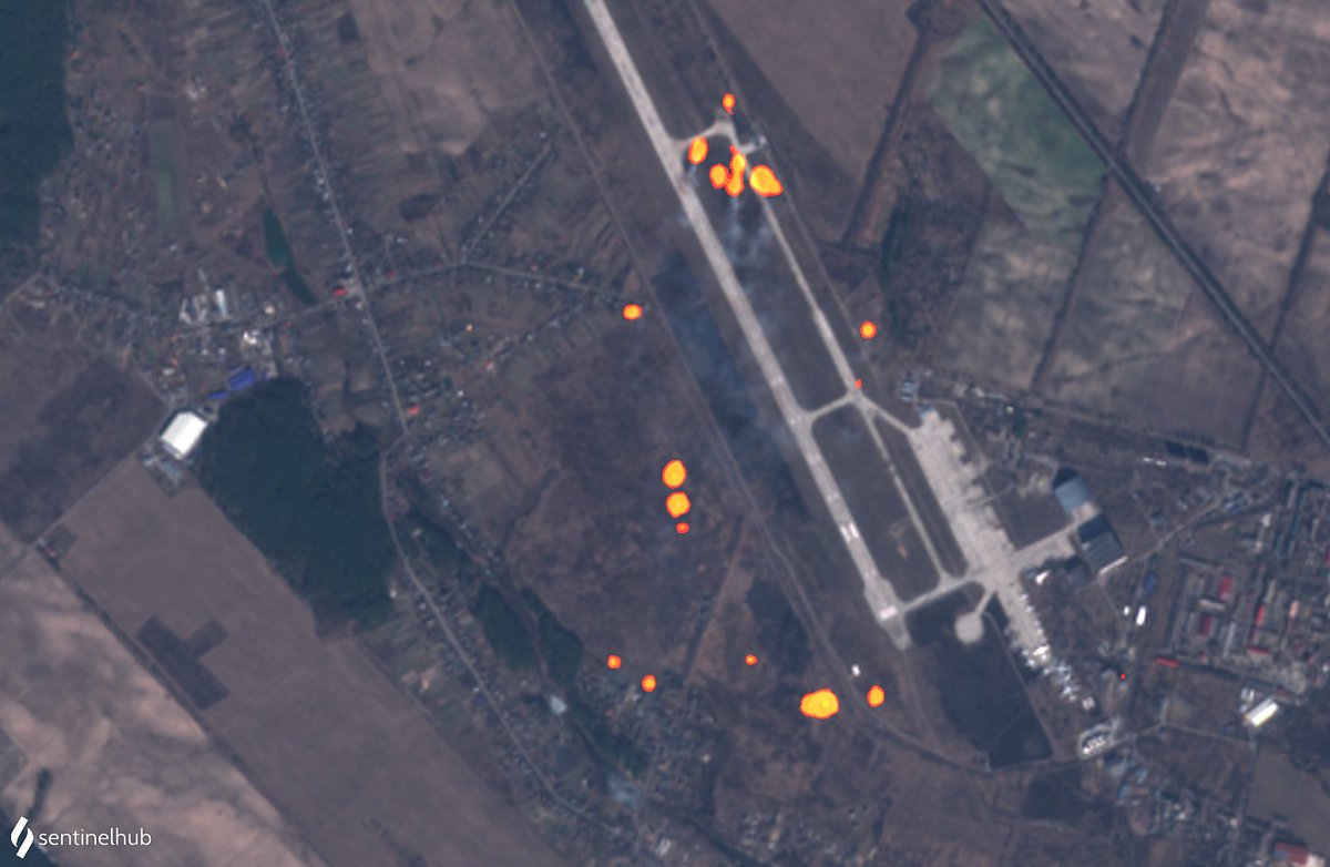
@Maxar Satellite imagery from @sentinel_hub shows multiple fires burning today (Feb 26) around Gostomel Airfield in Kyiv Oblast, Ukraine. Location: 50.593381, 30.204936. H/T to @il_kanguru who identified this.
https://twitter.com/il_kanguru/status/1497589392226983941?s=20&t=GsTNaznaYIpsEX8qG-d78A

Satellite imagery from @planet shows recent destruction of the Kamaryn Slavutych Border Crossing Bridge at the Ukraine and Belarus border here: 51.395485, 30.645746
Image on the left is from Feb 22, image on the right is from Feb 26.
Image on the left is from Feb 22, image on the right is from Feb 26.


@planet Geolocation of damage to residential building in Bucha, Kyiv Oblast [50.553611, 30.217778]
https://twitter.com/no_itsmyturn/status/1497825692418990080

@planet Geolocation of destroyed military equipment in Mykolaiv [46.964200, 32.026888]
https://twitter.com/shaunwalker7/status/1497868180492017664

@planet Satellite images from @Maxar show long line of Russian units on a road outside of Prybirs'k in Kyiv Oblast, about 70km north of Kyiv. Coordinates 51.018381, 30.029615


@planet @Maxar Heavy bombings seen in footage in Kharkiv recently. Coordinates are: 50.029440, 36.358299. H/T to @ToasterIntel for geolocation.
@planet @Maxar @ToasterIntel More footage showing heavy bombing in Kharkiv [50.028497, 36.362763][
https://twitter.com/momchil_ivanov1/status/1498238338859425792?s=20&t=zKf3Nb7bCgUn-dgAFPWdRg

@planet @Maxar @ToasterIntel Geolocation of aftermath of bombing in Kharkiv [49.927596, 36.435527]
t.me/livekharkov/28…
t.me/livekharkov/28…

@planet @Maxar @ToasterIntel Satellite imagery from @planet from Feb 27 shows smoke plumes bellowing from tanks just near Vasylkiv Air Base in Kyiv Oblast. Location of fire: 50.226359, 30.290443

@planet @Maxar @ToasterIntel Satellite imagery from @planet comparing between Feb 22 and Feb 27 shows multiple impact points of rocket attacks on Ozerne Airbase in Zhytomyr Oblast, Ukraine. Location: 50.159545, 28.745068


@planet @Maxar @ToasterIntel Geolocation of large convoy seen today in @Maxar satellite imagery 60km north of Kyiv. Convoy is facing south. H/T @COUPSURE for location: 50.891586, 29.976228

The Desna River Bridge near Zolotynka (Золотинка) in Ukraine's Chernihiv Oblast has been destroyed. @planet satellite imagery from Feb 26 and Feb 28 shows the clear difference. Location: 51.371572, 31.209581


@planet Destruction of hangar at Antonov International Airport, just outside of Kyiv. These satellite images from @planet from Feb 20 and Feb 28 show the damage to the hangar. Location: 50.592407, 30.211245


@planet Geolocation of footage showing bombing in Kherson. Note: this bombing was less than 100m from a kindergarten and children’s play area. Location of strike: 46.678951, 32.613883
https://twitter.com/michaelh992/status/1498603941214441478?s=20&t=nKL-y6yiiyLiKF3rMi0Jfg

@planet Geolocation of damaged and abandoned Russian military equipment in Borodyanka, Kyiv Oblast [50.645410, 29.939209]
https://twitter.com/RALee85/status/1498566462126108680

@planet Geolocation of tank firing at an apartment block in Borodyanka, Kyiv Oblast [50.642256, 29.929897]
https://twitter.com/IntelDoge/status/1498703033391325184

Satellite imagery from March 1 of Luninets airbase in Southern Belarus, about 60km from Ukraine's border, shows large strike capacity including SU-25 attack aircrafts. Location: 52.277138, 26.782122. Imagery from @planet.


@planet GRAPHIC: Geolocation of the footage showing a man and dog being shot dead in Ivankiv, Kyiv Oblast
[50.925932, 29.877105] Thanks to @LGalrao facebook.com/kate.morozova.…
[50.925932, 29.877105] Thanks to @LGalrao facebook.com/kate.morozova.…

@planet @LGalrao Geolocation of the footage showing Russian soldier allegedly waking around with 2 hand granades in Konotop, Sumy Oblast
[51.238349, 33.207274]
[51.238349, 33.207274]
https://twitter.com/osinttechnical/status/1498952937653125120?s=21

@planet @LGalrao Geolocation of the footage showing this morning's explosion at Odessa International Airport
[46.413633, 30.692319]
[46.413633, 30.692319]
https://twitter.com/nexta_tv/status/1498945034669993987?s=21

@planet @LGalrao Geolocation of the footage showing destruction of apartment building in Irpin, kyiv Oblast. [50.542076, 30.264558]
https://twitter.com/MarQs__/status/1498993475265699841

@planet @LGalrao Geolocation of footage showing a large impact hole in school, after a strike in Kharkiv [50.021103, 36.328125] Thanks to @Michael1Sheldon
t.me/hueviykharkov/…
t.me/hueviykharkov/…


Satellite imagery from 27 Feb captured a Russian MLRS rocket launch as it happened. Smoke plume is visible in the middle of the image. Thanks to @Michael1Sheldon who first spotted this. Imagery @planet Location: 50.300841, 36.651366

Very grim footage showing the destruction of an area along the Hostomel's'ke Hwy in Irpin, Kyiv Oblast, Ukraine. Source: t.me/milinfolive/77… Location: 50.542320, 30.263943
Geolocation of missile strikes in Chernihiv [51.499511, 31.277672]
https://twitter.com/nexta_tv/status/1499358871336460290

Geolocation of footage showing engine stage of a 9M79 Tochka 'SS-21 Scarab' Short-Range Ballistic Missile [OTR-21] in a residential area of Mariupol, Donetsk Oblast [47.112148, 37.553096] glavcom.ua/country/incide…


Geolocation of thermal power plant struck in Okhtyrka, Sumy Oblast [50.316770, 34.876943]
https://twitter.com/nexta_tv/status/1499405555206705153

Extensive Russian convoy line seen outside of Kyiv. @Maxar satellite imagery shows extensive buildup of convoy that has been traveling from the north over the past days towards Kyiv.
Geolocation of footage of downed Russian helicopter just outside of Kozarovychi (Козаровичі) in Kyiv Oblast. Location: 50.7605860, 30.3661308. H/T to @L_ThinkTank for location.
@L_ThinkTank Drone footage showing fighting in multiple areas in Bucha, Kyiv Oblast
https://twitter.com/markito0171/status/1499838283202899969

@L_ThinkTank Geolocation of a missile strike on a warehouse in Kharkiv [49.950587, 36.154536]
https://twitter.com/clashreport/status/1500377845675311105?s=20&t=EFbQ5pLkTaAre99oLfUTqA

@L_ThinkTank Geolocation of MRLS firing from Peremoha, Kyiv Oblast [50.498014, 31.259219]
https://twitter.com/COUPSURE/status/1500458608823345156

@L_ThinkTank We have geolocated footage of a missile flying over Vinnyts’ki Khutory, Ukraine. Location: 49.197576, 28.540447
https://twitter.com/no_itsmyturn/status/1500465245210525696?s=20&t=JeWpzHFM88j-nxOL-2HD-A


@L_ThinkTank Geolocation of further footage of what appears to be a missile flying over Gnivan, Ukraine. Location: 49.092351, 28.338282
https://twitter.com/Alex93419575/status/1500464867622461443?s=20&t=V8ubpdYywfXmSYm1tOJAAw

@L_ThinkTank Matching our two geolocations of two separate videos indicates a trajectory bound north for Vinnytsia Airport.
Geolocation 1 (
Geolocation 2 (
Geolocation 1 (
https://twitter.com/Cen4infoRes/status/1500489058790920200?s=20&t=0QDfAeO5gBqt6RgsqL7Hzg)
Geolocation 2 (
https://twitter.com/Cen4infoRes/status/1500488064443072512?s=20&t=0QDfAeO5gBqt6RgsqL7Hzg)

@L_ThinkTank Geolocation of destroyed residential building after strike in Kharkiv [50.034942, 36.229860]
https://twitter.com/no_itsmyturn/status/1500743554448113664

@L_ThinkTank Geolocation of footage of destroyed Russian fuel tankers seen yesterday in Chernihiv Oblast, Ukraine, 135km east of Kyiv. Location: 50.707261, 32.350936. H/T @john_marquee and @Danspiun.
https://twitter.com/UAWeapons/status/1500868256051216387?s=20&t=MMHwTEfXIFOUntectA63VQ

@L_ThinkTank @john_marquee @Danspiun Geolocation of church Voznesensʹka Tserkva, damaged due to shelling in Bobryk (Бобрик), Kyiv Oblast [50.655507, 31.073123]
https://twitter.com/michaelh992/status/1500499668089856002?s=21

Geolocation of destruction of Boiko Music School in the centre of Kharkiv [50.006521, 36.240386]
https://twitter.com/no_itsmyturn/status/1500782019697123328

Geolocation of footage showing damage after a strike at the Children's hospital in Mariupol, Donetsk Oblast [47.096947, 37.533261]
https://twitter.com/ThomasVLinge/status/1501581589213589514

New satellite imagery shows the level of destruction of civilian areas in Mariupol, Ukraine. These images from @Maxar show Portcity Shopping Mall (ТРЦ ПортCity) on March 9 and how it looked before. Location: 47.116022, 37.508387.


@Maxar Satellite imagery from March 9 shows the destruction of a residential neighbourhood in Mariupol, with apartment buildings and homes destroyed. Imagery is from @Maxar. Location: 47.099153, 37.661702


@Maxar Satellite imagery from March 9 showing both Epicentr K and Silpo shopping centres destroyed in Mariupol's Zhovtnevyi district. Location: 47.098799, 37.502374. Imagery from @Maxar


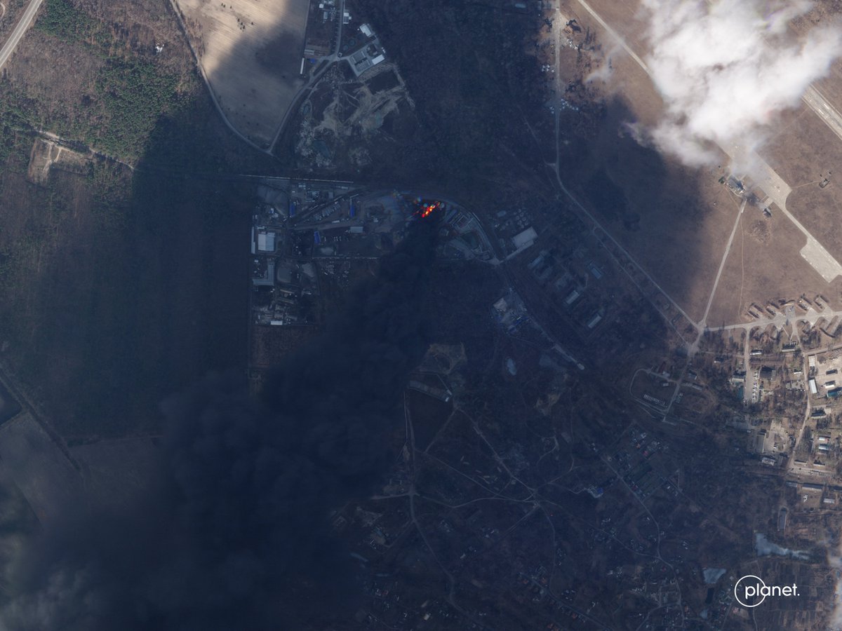
@Maxar Satellite imagery from @Maxar shows a fire bellowing from Chernihiv's industrial area in the south after attacks targeting the area on March 10. Location: 51.462766, 31.257669

@Maxar Satellite imagery from @Maxar shows further destruction of shopping malls in Ukraine. This time Chernihiv's 'Epicenter K' (Епіцентр). Location: 51.525938, 31.328604.
Our team has previously mapped footage showing the centre on fire on Feb 28:
Our team has previously mapped footage showing the centre on fire on Feb 28:
https://twitter.com/no_itsmyturn/status/1498252747291992064?s=20&t=egaAULa5J_8Rwbl6RuuhNg

@Maxar Geolocation of destruction after strikes in Izyum, Kharkiv Oblast [49.197304, 37.278129]
t.me/truexanewsua/3…
t.me/truexanewsua/3…

@Maxar Geolocation of widespread damage after strike in Baryshivka, Kyiv Oblast [50.362202, 31.325572]
https://twitter.com/ukrpravda_news/status/1502201438700720131

@Maxar Geolocation of heavily damaged apartment block after a strike in Milova, Kharkiv Oblast [49.447385, 36.706435]
t.me/truexanewsua/3…
t.me/truexanewsua/3…

@Maxar Geolocation of civilian casualty on the highway between Kharkiv and Chuhuiv [49.913989, 36.480897]
t.me/truexanewsua/3…
t.me/truexanewsua/3…

Smoke clouds bellow out of a fuel depot at Antonov International Airport, near Kyiv, in this satellite image from March 11. Image from @planet. Location: 50.585375, 30.211969

@planet Geolocation of Russian forces in Kherson (Херсон) yesterday. Location: 46.636665, 32.620285
https://twitter.com/RALee85/status/1502990913819357184?s=20&t=wzB8SR9NSvJS9OxqS-5CwQ


@planet Satellite imagery from @Maxar shows Russian artillery firing positions near Ozera on March 11. Multiple smoke clouds seen and muzzle flash (seen on satellite banding). Location: 50.622276, 30.200311. Thanks to @doppelot for geolocation.


@planet @Maxar @doppelot Geolocation of footage showing downed missile in Kurenevka district, Kyiv [50.488804, 30.468037]
https://twitter.com/MarQs__/status/1503330763965714435

@planet @Maxar @doppelot Geolocation of footage showing a Russian tank firing at an unknown target in Volnovakha, Donetsk Oblast [47.617972, 37.494911]
https://twitter.com/NotWoofers/status/1503368259478990853

@planet @Maxar @doppelot Satellite imagery from @Maxar yesterday shows Mariupol, with shopping malls, urban and residential areas destroyed from shelling and strikes. Location: 47.100108, 37.505112

Imagery from @Maxar (14/3) also shows clear damage to hospital and civilian residential areas in Mariupol. Location of Лікарня №2 Hospital is here: 47.110865, 37.512538

@Maxar Geolocation of drone footage showing a civilian being shot by Russian soldiers in Myla, Kyiv Oblast [50.440231, 30.148146]
https://twitter.com/ZDFfrontal/status/1503751916395843593

@Maxar Satellite imagery shows large fire and a number of aerial assets destroyed in Russian-occupied Kherson Airbase yesterday following a Ukrainian attack. Location: 46.672634, 32.506839. Imagery by @planet.


@Maxar @planet Satellite image of the Olympic Sports Training Center in Chernihiv, taken yesterday by @Maxar. Location: 51.501429, 31.326495

@Maxar @planet Satellite imagery from @Maxar of Russian firing positions (dated yesterday) located 17km NE of Chernihiv. Location: 51.612662, 31.456936


@Maxar @planet Location of homes seen burning in satellite imagery from March 16 in Chernihiv: 51.522603, 31.363503.

This theatre in Mariupol was bombed. It was claimed many were seeking refuge in the building (bbc.co.uk/news/world-eur…). Satellite imagery from March 14 from @Maxar shows "children" written on the ground on both sides of the building. Location: 47.096119, 37.548222


@Maxar Geolocation of civilian vehicles coming under fire in Buzova, Kyiv Oblast [50.430847, 30.029837]
https://twitter.com/nexta_tv/status/1504873552864022563

@Maxar Satellite imagery from March 18 provided by @Maxar shows large-scale destruction in Ukraine's Mariupol.
H/T to @fs0c131y for geolocations.
Location of image 1: 47.11127, 37.55346
Location of image 2: 47.10623, 37.51134
H/T to @fs0c131y for geolocations.
Location of image 1: 47.11127, 37.55346
Location of image 2: 47.10623, 37.51134
https://twitter.com/fs0c131y/status/1504932149916487682?s=20&t=R_XKaXHI_6o4ftRbPqVLNA


@Maxar @fs0c131y Kyiv Mayor Vitali Klitschko showing buildings destroyed in Kyiv yesterday. Location: 50.510173, 30.432298.
Source: t.me/Pravda_Gerashc…
Source: t.me/Pravda_Gerashc…
@Maxar @fs0c131y Geolocation of footage from yesterday of Kyiv Mayor Vitali Klitschko showing destruction in Kyiv shows impacted buildings included pre-schools, education facilities and homes. Location: 50.510173, 30.432298.
https://twitter.com/Cen4infoRes/status/1505199143463133187?s=20&t=zFPcpFf3Qiy4_d070M0QOQ

@Maxar @fs0c131y Satellite imagery from yesterday from @Maxar showing the destruction of Mariupol's Drama Theatre. Clear signage seen in front of the building of the Russian word ДЕТИ - Children. Location: 47.096137, 37.548157


@Maxar @fs0c131y Geolocation of a Russian tank firing in the city of Mariupol, Donetsk Oblast [47.100651, 37.667229]
https://twitter.com/MarQs__/status/1505918343387176968

@Maxar @fs0c131y Impact craters seen where multiple homes have been clearly destroyed in Chernihiv, seen on @Maxar satellite imagery from March 21 Coordinates: 51.524639, 31.375828


Damaged metallurgical plant in Mariupol seen on satellite imagery yesterday from @planet. Coordinates 47.10781, 37.6077

@planet Satellite imagery from Kharkiv between March 12 & March 22 shows the scale of what appears to be impacts from repeated strikes. Location: 50.091374, 36.259667.
@planet Geolocation of satellite imagery shared by @Maxar showing a new military camp [51.749420, 30.292118] near the town of Dublin [Gomel Region] Belarus.

Satellite imagery taken by @Maxar yesterday shows extent of damage after strikes on Mariupol's Azovstal iron and steel works factory. Location: 47.105059, 37.607057


Multiple images taken yesterday showing widespread destruction in Mariupol. Some of the images seen around this location: 47.107542, 37.649521


Imagery from @sentinel_hub today shows a large smoke plume emerging from a port in occupied port city of Berdyansk. More information: bbc.co.uk/news/world-eur…. Location: 46.749655, 36.774893


@sentinel_hub Damage to buildings in medical area and clear impact crater in a sport field in Izyum seen in @Maxar satellite imagery from yesterday. Location: 49.189019, 37.273789

@sentinel_hub @Maxar Hi-res images of the event we documented yesterday at the port of Berdyansk where a Russian vessel was struck. Location: 46.749655, 36.774893. 📸 @Maxar
https://twitter.com/Cen4infoRes/status/1507006585079414786?s=20&t=CSvUdBNVmfCRKCnHgzjVFA


@sentinel_hub @Maxar Satellite imagery from @Maxar yesterday shows what appears to be a line of artillery driving south towards Izyum. H/T to @gfusfus for location. Coordinates: 49.249497, 37.235875

@sentinel_hub @Maxar @gfusfus Geolocation of footage of pro-Russian Kadyrov Chechen fighters in Mariupol. Location: 47.098281, 37.636278
@sentinel_hub @Maxar @gfusfus Aftermath of bombings on Saturday in Kharkiv in front of a secondary school on Baturynska St in the Zayikivka area. Location: 49.973351, 36.229351. Source: t.me/Pravda_Gerashc…
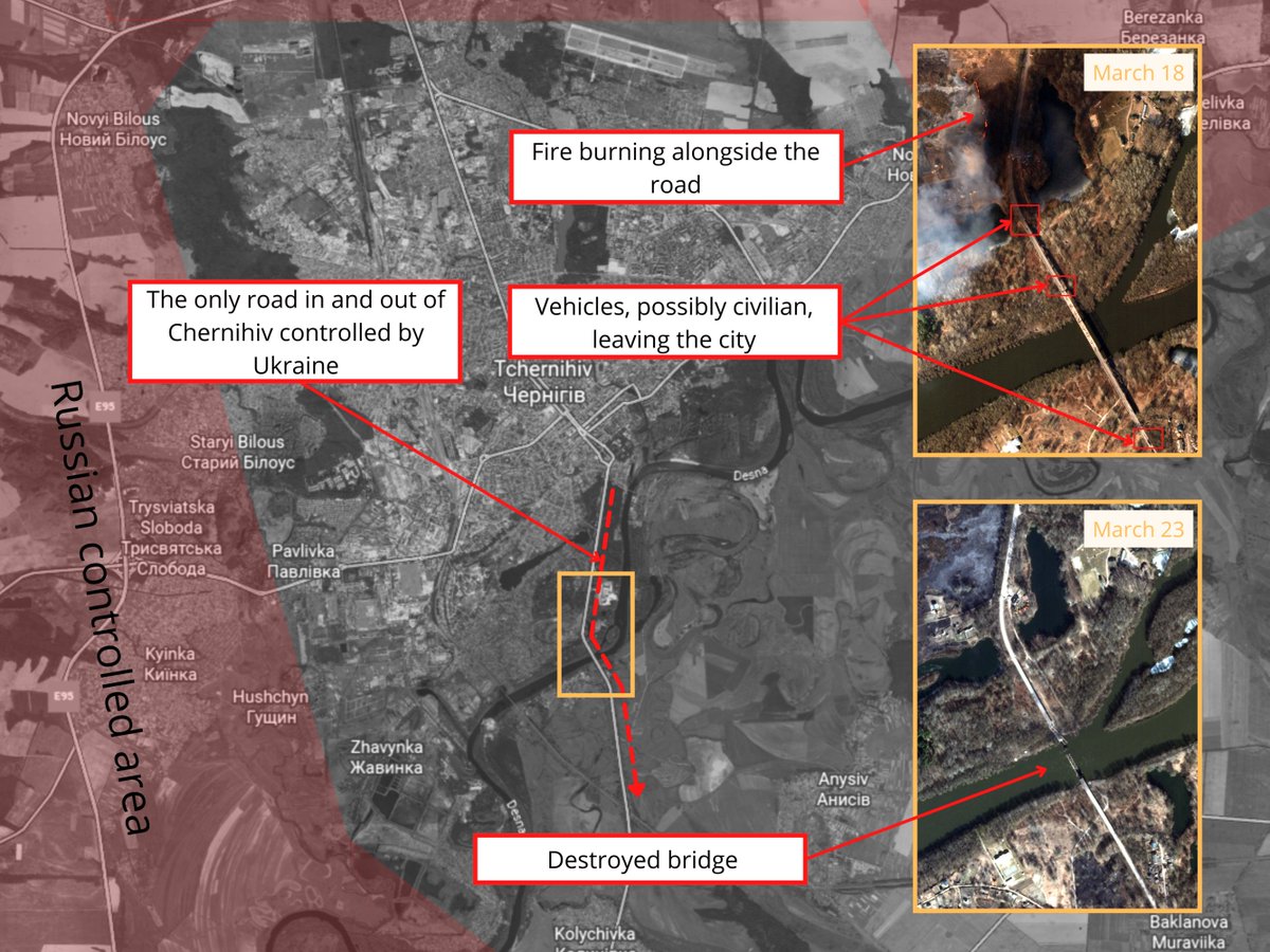
@sentinel_hub @Maxar @gfusfus Satellite imagery from March 23 shows the only route out of the besieged city of Chernihiv, the bridge across the Desna river [51.457311, 31.301379] has been destroyed
@sentinel_hub @Maxar @gfusfus Hi-resolution satellite imagery, taken yesterday, shows a closeup of the destruction of Mariupol's drama theatre. 📸 @Maxar Location: 47.096102, 37.548183


@sentinel_hub @Maxar @gfusfus Lines of people queuing outside a Metro Cash & Carry in Ukraine's Mariupol on satellite imagery taken yesterday by @Maxar. H/T to @Mike_Eckel for sharing. Location: 47.118457, 37.503235


@sentinel_hub @Maxar @gfusfus @Mike_Eckel Satellite imagery from @Maxar shows Russian forces have established a camp in Ukraine at Chaplynka airfield, Kherson Oblast. Helicopters and vehicles have been deployed to the camp and entrenchments have been dug.
[Location: 46.3456885, 33.5413067]
[Location: 46.3456885, 33.5413067]

@sentinel_hub @Maxar @gfusfus @Mike_Eckel A mass grave near the Church of St. Andrew and Pyervozvannoho All Saints in Bucha, Kyiv Oblast [50.548258 30.205485] seen on @planet satellite imagery from March 21. The BBC reported on March 14 that 67 bodies that had been brought to the hospital in Irpin were buried here

@sentinel_hub @Maxar @gfusfus @Mike_Eckel @planet Satellite imagery from @Maxar taken over Bucha on March 31 shows numerous destroyed military vehicles and surrounding residential area. On ground footage can be seen on our Russia-Ukraine Monitor Map here: maphub.net/Cen4infoRes/ru…. Location: 50.543945, 30.226708

@sentinel_hub @Maxar @gfusfus @Mike_Eckel @planet Geolocation of graphic images showing the aftermath of shelling of the distribution of Aid, at a school in Vuhledar, Donetsk Oblast [47.780986, 37.254019] h/t @gfusfus
https://twitter.com/GirkinGirkin/status/1511639432910319621

@sentinel_hub @Maxar @gfusfus @Mike_Eckel @planet Graphic images from the train station in Kramatorsk, Donetsk Oblast showing a large number of casualties in multiple locations around the train station
https://twitter.com/StratcomCentre/status/1512347083134615553

@sentinel_hub @Maxar @gfusfus @Mike_Eckel @planet Satellite imagery from @Maxar dated April 8 shows a long Russian military convoy moving south through Velykyi Burluk. Location: 50.078247, 37.386107


@sentinel_hub @Maxar @gfusfus @Mike_Eckel @planet New satellite imagery from @Maxar dated April 9 shows large amounts of destruction and numerous fires burning in Ukraine's Mariupol.
Image 1: 47.079, 37.508
Image 2: 47.109, 37.611
Image 3: 47.108, 37.635
Image 1: 47.079, 37.508
Image 2: 47.109, 37.611
Image 3: 47.108, 37.635


@sentinel_hub @Maxar @gfusfus @Mike_Eckel @planet Satellite imagery of Kherson Airbase shows buildup of Russian forces with dug in positions. Some vehicles appear to be marked with the "Z" symbol. Location: 46.676, 32.508. 📸 @Maxar


Satellite imagery from April 11 shows new buildup of Russian forces west of Soloti, Russia, just over 20km from Ukraine's border. Location: 50.241, 37.972

Large buildup was also seen on @Maxar satellite imagery from April 9, close to Ukraine's border near Dubrovka and Biriuch in Russia.
Image 1: 50.240322, 37.730044
Image 2: 50.251931, 37.719065
Image 1: 50.240322, 37.730044
Image 2: 50.251931, 37.719065


Satellite imagery from April 11 shows large convoy of military vehicles along T-1313 highway near Bilokurakyne in Ukraine. Convoy appears to be facing south towards Luhansk. Location: 49.554, 38.724. 📸@Maxar


@Maxar Geolocation of Russian positions being shelled inside a forest last month, near Motyzhyn, Kyiv Oblast
[50.394452, 29.966034]
[50.394452, 29.966034]
https://twitter.com/RALee85/status/1514533842614423558

@Maxar New graves seen on satellite imagery from @Maxar (published yesterday) in Manhush (Мангуш) just under 18km west of Mariupol. Location: 47.073233, 37.300564
Timelapse shows imagery from 19/3 - 03/04
Timelapse shows imagery from 19/3 - 03/04
@Maxar Satellite imagery from @Maxar taken on April 29 shows a very heavily targeted Azov Steel in Mariupol. Location: 47.107, 37.606


@Maxar Satellite imagery from @Maxar taken on April 29 shows Mariupol Theater and many destroyed buildings around city centre (location: 47.095, 37.547)

Satellite imagery from @Maxar taken on April 29 shows severe destruction of homes and buildings around Mariupol train station (location: 47.085, 37.555)

Satellite imagery from @Maxar taken on April 29 shows Heavy damage to residential apartment buildings in Livoberezhnyi District (location: 47.099, 37.628)

Satellite imagery from @Maxar taken on April 29 shows Vynohradne cemetery with self-propelled artillery deployed nearby (location: 47.097, 37.714)


Satellite imagery comparison of Mariupol's Azovstal metallurgical plant from March 21 & May 1 shows the focus and rate of Russia's bombing campaign of the industrial plant. Location: 47.108469, 37.608435. 📸 @planet
• • •
Missing some Tweet in this thread? You can try to
force a refresh


