The Visual Investigations team is contributing to the @nytimes liveblog on the Russia and Ukraine war: nytimes.com/live/2022/02/2…. Threading updates here too. 

Update: This video shows a bridge spanning the Dnieper just north of Kyiv was destroyed in an apparent attempt to slow down the advancing Russian forces. Another bridge on a western highway leading into the Ukrainian capital was destroyed too, photos show. nytimes.com/live/2022/02/2…
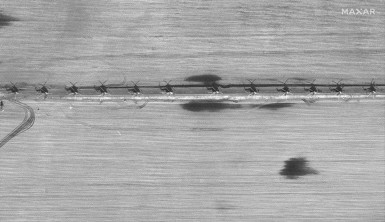
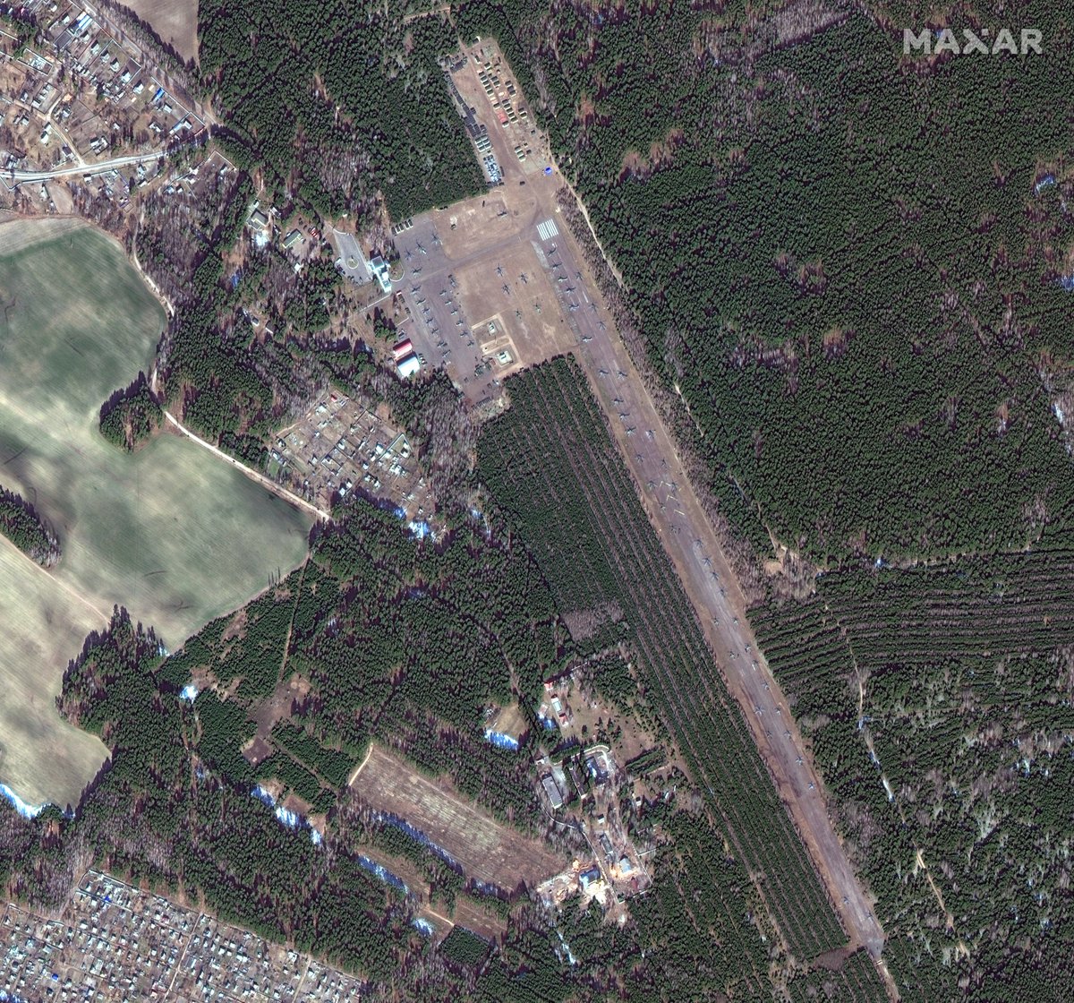
Satellite images collected by @Maxar show over 90 helicopters lined up along a road in a rural area of Belarus, 90 miles from Kyiv — including both attack and transport helicopters, the same types seen during Hostomel airport assault. By @ckoettl. nytimes.com/live/2022/02/2… 



More evidence of widely banned cluster munitions in Ukraine, likely by Russia. This video (via @kromark @belligncat @CalibreObscura) appears to show a 9M27K cluster warhead rocket near a residential block in Okhtyrka. By @evanhill and @johnismay.
nytimes.com/live/2022/02/2…
nytimes.com/live/2022/02/2…
Videos from yesterday that show the aftermath of clashes between Ukrainian and Russian forces near a train station in Kyiv and a car dealership Mykolaiv. By @heytherehaley and @tiefenthaeler. nytimes.com/live/2022/02/2…
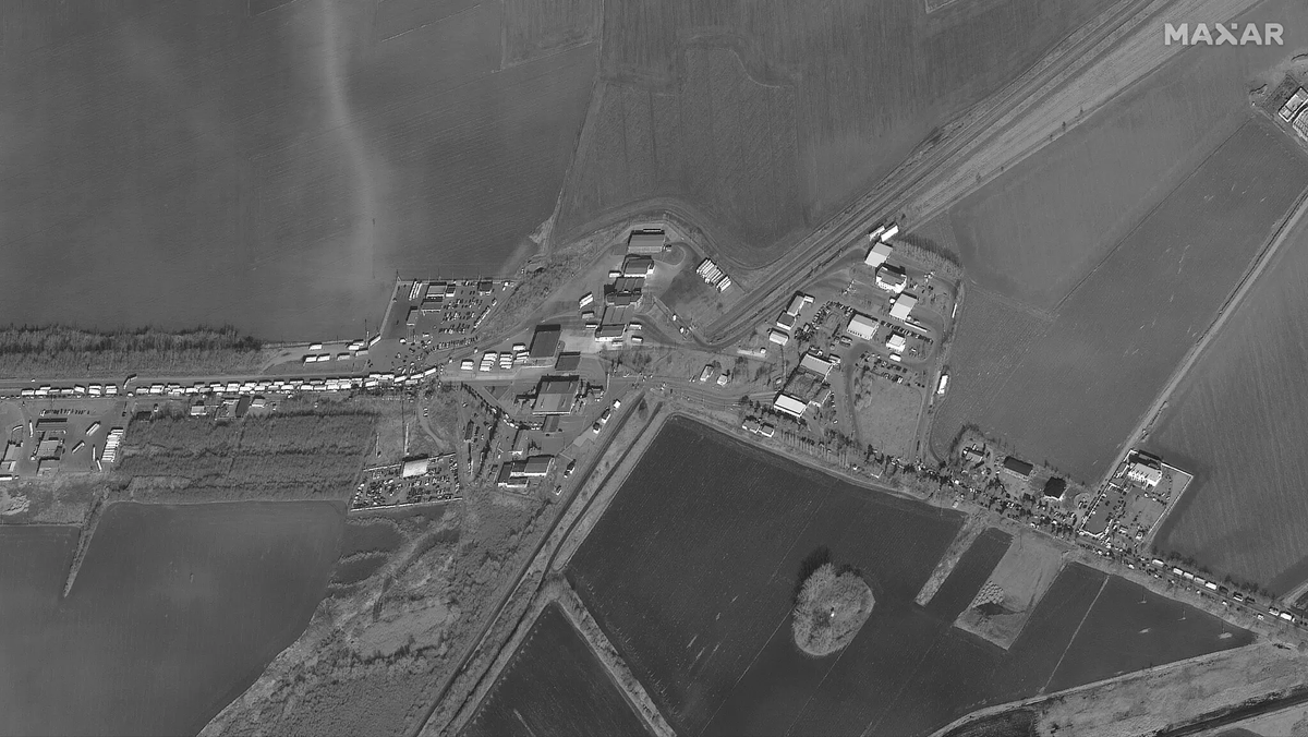
Satellite images collected by @Maxar this Friday show a 4-mile traffic jam of vehicles at the Siret border crossing with Romania. Some 368,000 Ukrainians have fled to European neighbors since Russia invaded, per UN refugee agency. By @bottidavid. nytimes.com/live/2022/02/2… 


“Take some sunflower seeds and put them in your [pocket]. So when you die here, sunflowers will grow from that spot.” Videos from Bakhmach and Henichesk show Ukrainian citizens confronting Russian soldiers. By @dim109 @tiefenthaeler @ckoettl @brenna__smith nytimes.com/live/2022/02/2…
This video shows intense fighting at a traffic circle near Ivankiv, about 40 miles northwest of Kyiv. The Ukrainian soldier seen in the video is carrying what appears to be a U.K.-provided NLAW shoulder-fired missile. By @dim109 @ckoettl @johnismay. nytimes.com/live/2022/02/2…
After intense street battles on Sunday, footage shows the charred remains of military vehicles in Bucha, situated on the outskirts of Kyiv. By @tiefenthaeler, @heytherehaley and @ajcardia. nytimes.com/live/2022/02/2…
(That second clip in the video above shows apparent Russian troops firing at an Afghanistan War memorial of a military vehicle — which they may have mistaken for Ukrainian forces?)
Ukrainian officials on Monday accused Russian forces of launching a barrage of rockets on a residential neighbourhood in Ukraine's second largest city, Kharkiv, killing dozens of civilians, just as officials were preparing to meet for talks in Belarus.
https://twitter.com/tiefenthaeler/status/1498285710079676416
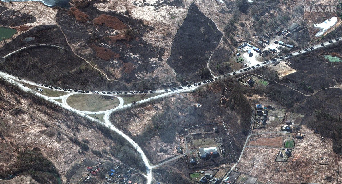
A large convoy of Russian armed forces is moving closer to Kyiv, about 20 miles north of Antonov airport on the outskirts of Kyiv. The convoy is stretched out over at least 17 miles, with some gaps. By @ckoettl. nytimes.com/live/2022/02/2… 

The line of vehicles is so extensive that it was not entirely captured in today’s satellite imagery. In some areas, the vehicles are two to three rows deep. nytimes.com/live/2022/02/2…
More striking satellite imagery of the Russian convoy north of Ivankiv, heading to Kyiv, collected by @Maxar on Feb 28. 


Satellite imagery of Feb. 28 show at least 63 helicopters deployed at V.D. Bolshoy Bokov airfield near Mazyr in Belarus, which is around 40km from the border with Ukraine. The field hospital was spotted a week ago already. Image by @Maxar. 


Video shows a projectile hit apartment buildings next to a kindergarten in Kherson, a city that's been a target of Russia's assault into the south. While Russian soldiers roam the street, mayor says city is “still Ukraine.” By @heytherehaley @tiefenthaeler nytimes.com/live/2022/03/0…
In addition to the helicopters, here are Feb. 28 images, aslo from @Maxar, of ground forces and equipment in Belarus in respectively Teshkov (Тешков) and Khil’chikha (Хильчиха). Unclear whether these are Russian or Belarusian. 

https://twitter.com/trbrtc/status/1498626050233933828


Videos from the coastal city of Berdyansk showed angry residents protesting Russian troops on Monday (Feb. 28) after they occupied the city overnight. The mayor said that he didn't accept the Russian proposal to continue working under Russian control.
https://twitter.com/evanhill/status/1498420981236445186
A bridge along the M01/E95 near Shestovytsya (Шестовиця) over the Desna River has been destroyed, @planet satellite imagery of Feb. 26 and Feb. 28 shows. This is in the Chernihiv Oblast north of Kyiv, about 40km from the border with Belarus. 


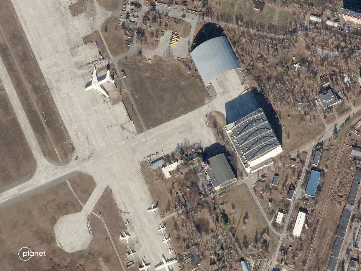
Before and after @planet satellite imagery of Hostomel airport shows the damaged hangar under which the world's largest aircraft — the Antonov An-225 “Mryia” (dream, inspiration) — is stored. You can see part of it peaking out. The extent of the damage is unclear. 


This thread highlights several ways how a video can be digitally examined for its veracity: What/Where/When.
https://twitter.com/trbrtc/status/1498059980544438273
Liveuamap — one of the key online resources to follow the Russian invasion of Ukraine — tells me they have been under “heavy” DDOS attacks for “nearly 18 hours.”
https://twitter.com/trbrtc/status/1498673032516227082?s=20&t=-OKVRsZ9X8BNc938ryaVPg
At least two explosions observed in the buildings right under the Kyiv TV Tower, following the statement of the Russian military that they would target “objects” related to the SBU and 72nd PsyOps in Kyiv. t.me/bazabazon/10155
The broadcasting hardware related to the TV tower was hit, the Ukrainian Interior Ministry said in a statement on Facebook. “Channels will be off air temporarily [...] The enemy may try to spreads misinformation and destabilize the situation.” facebook.com/photo/?fbid=32… 

This video clearly shows a projectile hitting the Kyiv TV tower. Other videos captured at least two more explosions in the immediate area next to the tower. The freestanding lattice tower itself is still standing. nytimes.com/live/2022/03/0…
Popular mapping tool @Liveuamap, whose website was founded by Ukrainians and whose main operation is in Ukraine, has been under a sustained DDoS attack — nearly 18 hours. Cloudfare is directly assisting. nytimes.com/live/2022/03/0…
Video verified by @nytimes shows two people confronting at least three Russian airborne infantry fighting vehicles lined up in front of Kherson's town hall with their guns facing outward. Russian troops have “completely surrounded” the southern port city. nytimes.com/live/2022/03/0…
Russian troops have “completely surrounded” the southern port city of Kherson, a Ukrainian official said this morning. With its 300K inhabitants, Kherson would be the largest city to be seized by Russia so far. w/ @tiefenthaeler @bottidavid @MarcSantoraNYT nytimes.com/live/2022/03/0…
A video verified by @nytimes shows two Su-25 attack aircraft bombing apartments in Irpin, just outside Kyiv, this morning. Aftermath footage shows that two floors were completely destroyed. Police said it wasn't immediately clear if there were casualties. nytimes.com/live/2022/03/0…
In Konotop, a Russian soldier held grenades above his head as he walked through angry crowd. The mayor said Russian soldiers told him they would “raze the city to the ground with artillery” if they didn't surrender. By @dim109 @bottidavid @tiefenthaeler. nytimes.com/2022/03/02/wor…
In response, the mayor, Artem Semenikhin, asked the crowd whether they wanted to surrender or fight. The response was overwhelmingly in favor of fighting. “I am too,” the mayor said. “But the decision has to be unanimous because their artillery is already trained on us.”
Clouds cover has blanketed Ukraine over the past two days, but satellite imagery from Feb. 27-28 give a sense of the growing humanitarian crises: long lines at grocery stores and border crossings.
https://twitter.com/heytherehaley/status/1499333595890176001
Dash camera video verified by @nytimes captures projectiles falling and landing, followed by large explosions, on a residential area in the center of Chernihiv, the key northern city along the path of Russia’s incursion into Ukraine toward Kyiv.
https://twitter.com/heytherehaley/status/1499375714692444165
Earlier today, a huge blaze was observed at the site of Europe's nuclear power plant. Now, Ukrainian officials say the fire has been extinguished and that the plant is operating normally after Russian troops seized the Zaporizhzhia compound.
https://twitter.com/brenna__smith/status/1499576591789273088
This 3D video by @Maxar shows the Russian military convoy northwest of Kyiv (not the entire 40-mile length, but gives a good impression). Note: this is from the previously Feb. 28 satellite imagery. It's been too cloudy for new satellite imagery updates.
Russians forces appeared to be driving freely around the southern Ukrainian city of Enerhodar, hours after heavy fighting ended at the city's nuclear power plant — the largest in Europe, now under Russian control. w/ @heytherehaley @bottidavid nytimes.com/live/2022/03/0…
A severely damaged Ukrainian Kozak-2 armored personnel carrier was photographed at the entrance to the heavily fenced-off nuclear reactors in Enerhodar. The known fighting took place just outside this gate. t.me/milinfolive/77… 

Mariupol, a key port city, is under siege for days and is nearing a “humanitarian disaster.” Images have emerged only sporadically because of power and network outages. “We only hear blasts.” By @MashaFroliak @tiefenthaeler @heytherehaley @dim109 @sskerrr. nytimes.com/live/2022/03/0…
“Stop firing at the nuclear facility. Immediately stop firing. You are endangering the safety of the entire world.”
https://twitter.com/brenna__smith/status/1499939675812904965
A @nytimes team filmed the moment that civilian evacuees in Irpin, northwest of Kyiv, were fired upon by Russian forces, leaving four people dead including two children. nytimes.com/2022/03/06/wor…
“Only a dozen or so Ukrainian soldiers were in the immediate area of the bridge on Sunday, not fighting but helping carry civilians’ luggage and children,” writes @lynseyaddario who witnessed the attack. nytimes.com/2022/03/06/wor… 
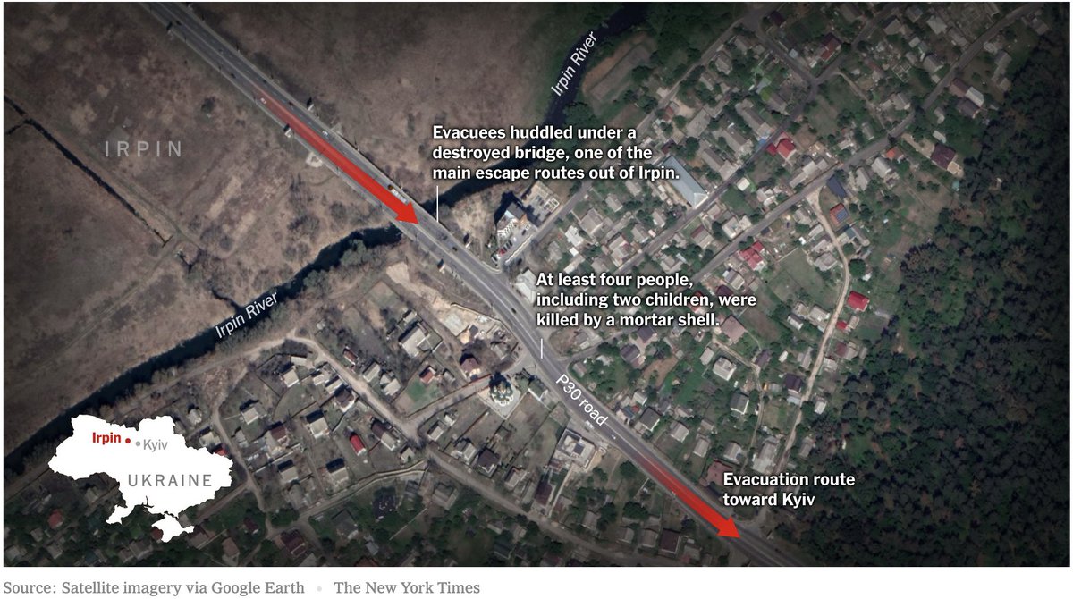
This video was filmed by @DubchakA, part of the @nytimes team in Irpin.
https://twitter.com/trbrtc/status/1500751880460378113
New radar satellite imagery of Vinnytsia Airport in western Ukraine shows damage to air traffic control towers and an aircraft — but no apparent damage to the runway, similar to other airfields targeted by the Russian military.
https://twitter.com/ckoettl/status/1501313942144040963
Heavy cloud-cover obscures much of Ukraine, @Maxar notes, but some satellite imagery collected on March 8 shows military activity near Hostomel's Antonov Airport, as well as a view of people leaving Irpin near the damaged bridge. 


“May God provide us wisdom so we can evacuate people.”
https://twitter.com/muyixiao/status/1501363027765080070
New @planet satellite imagery, collected on March 8, continues to show over 70 helicopters at Machulishchy Air Base in Belarus. Some of the rotary wing aircraft are suspected to be Russian. 
https://twitter.com/Gerjon_/status/1500923660915380224

An apparent Russian strike today damaged and destroyed buildings at a City Hospital No. 3 in the southern Ukrainian city of Mariupol, including a maternity ward, according to several videos verified by @tiefenthaeler @evanhill @dim109 @MashaFroliak. nytimes.com/2022/03/09/wor…
More than two dozen homes have been damaged or destroyed in Moshchun, a town northwest of Kyiv and four miles east of Antonov Airport. Oil storage tanks next to the airport were also on fire.
https://twitter.com/ckoettl/status/1502369824994910212
Kyiv’s police force said that law enforcement officers and volunteers had been evacuating residents from Moshchun over the past three days.
https://twitter.com/muyixiao/status/1502374468894740482
An artillery battalion near Ozera (Озера) was captured actively firing in southeastern direction on this satellite image by @Maxar. Smoke comes out of five other artillery guns too, suggesting they recently fired as well. 

The multispectral bands on @Maxar's WorldView-2 satellite were used to highlight the bright muzzle flash coming out of one of the artillery guns. 

I'll add updates from the Visual Investigations team that were published over the weekend:
On March 12, this surveillance footage from Mykolaiv, southern Ukraine, shows a projectile hitting the ground while a pedestrian is walking about 70 ft away. It was not immediately clear whether there were any injuries.
https://twitter.com/muyixiao/status/1502705052103983109
On March 13, a military base in western Ukraine known for training foreign fighters was severely damaged by attacks. The facility is about 12 miles from the Polish border. By @heytherehaley, @tiefenthaeler and @YousurAlhlou. nytimes.com/live/2022/03/1…
There are thousands of foreign volunteers in Ukraine, including U.S. citizens. But the attack on their training camp left some wondering if they'll ever see the front lines. By @YousurAlhlou, Mark Boyer, @docubrent, Benjamin Foley and Andriana Zmysla.
nytimes.com/video/world/eu…
nytimes.com/video/world/eu…
On March 14, this nine-story apartment building in Kyiv's northern Obolon district was set ablaze across multiple floors after reports of artillery strikes.
https://twitter.com/cliffordlevy/status/1503350147417358343
About 1,000 people had been inside but it was not immediately clear how many had survived, said Pyotr Andryuschenko, an assistant to the mayor, because shelling had continued. “We hope at least some people survived.”
https://twitter.com/ckoettl/status/1504182123531485187
Pavlo Kyrylenko, the regional governor, blamed a Russian airstrike for the destruction at the Drama Theater of Mariupol. The Russian Ministry of Defense denied carrying out the attack. By @ckoettl, @dim109 and @VALERIEinNYT. nytimes.com/live/2022/03/1…
Satellite company @Maxar released a new set of images that show some of the damage caused by Russian airstrikes and artillery. This is Mariupol, showing devastation to residential homes, apartment buildings and stores in north and west of the Ukrainian port city. 


There's widespread destruction in Moschun, a small town northeast of Kyiv, as is visible on this @Maxar satellite image. The homes have likely been destroyed by artillery shelling. 

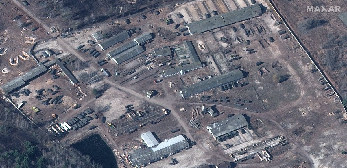
“Russian forces are increasingly using earthen revetments (berms) to protect/conceal their armored equipment deployments near Antonov Airport in Hostomel as well as other locations in and near Zdvyzhivka and Berestyanka,” @Maxar notes. Self-propelled artillery and MRLS visible. 




• • •
Missing some Tweet in this thread? You can try to
force a refresh


