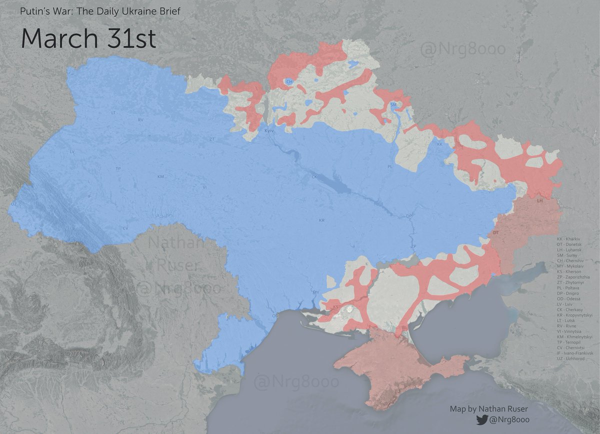
Putin's War - The Daily Brief - March 31
5 weeks ago, Russia invaded Ukraine. After some initial gains, their progress rapidly slowed. Now, every day for the past week, Ukraine has retaken more territory than it's lost.
See this thread for a series of maps and downloadable data.
5 weeks ago, Russia invaded Ukraine. After some initial gains, their progress rapidly slowed. Now, every day for the past week, Ukraine has retaken more territory than it's lost.
See this thread for a series of maps and downloadable data.

To highlight the significance of the past week, here is a gif showing changes compared to a similar map I made last week. All the areas circled in blue are where Ukrainian forces have gained territory, in red shows where Russian forces have.
(ignore the changing colour scale)
(ignore the changing colour scale)
These maps show the forward line of Russia's troops. A significant portion of the land behind these lines remains outside of what I would define as their firm control. See this map below for a more detailed map of territory under firm Russian (red) and Ukrainian (blue) control.
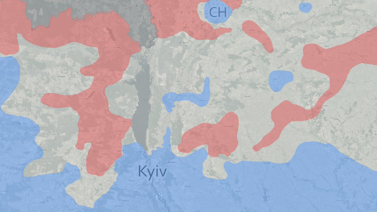
The challenge for Russian forces approaching Kyiv from the East is much clearer in this view. They have only recently managed to establish supply lines to their forward troops in Brovary, and these have constantly been destroyed and attrited by Ukrainian forces.
If any journalist or interested person wants to download this control data for your own visualisation or to explore in Google Earth, you can download the file here
mega.nz/file/2FBEWCDI#…
🤙 Please credit me in any maps made from this data 😊
mega.nz/file/2FBEWCDI#…
🤙 Please credit me in any maps made from this data 😊
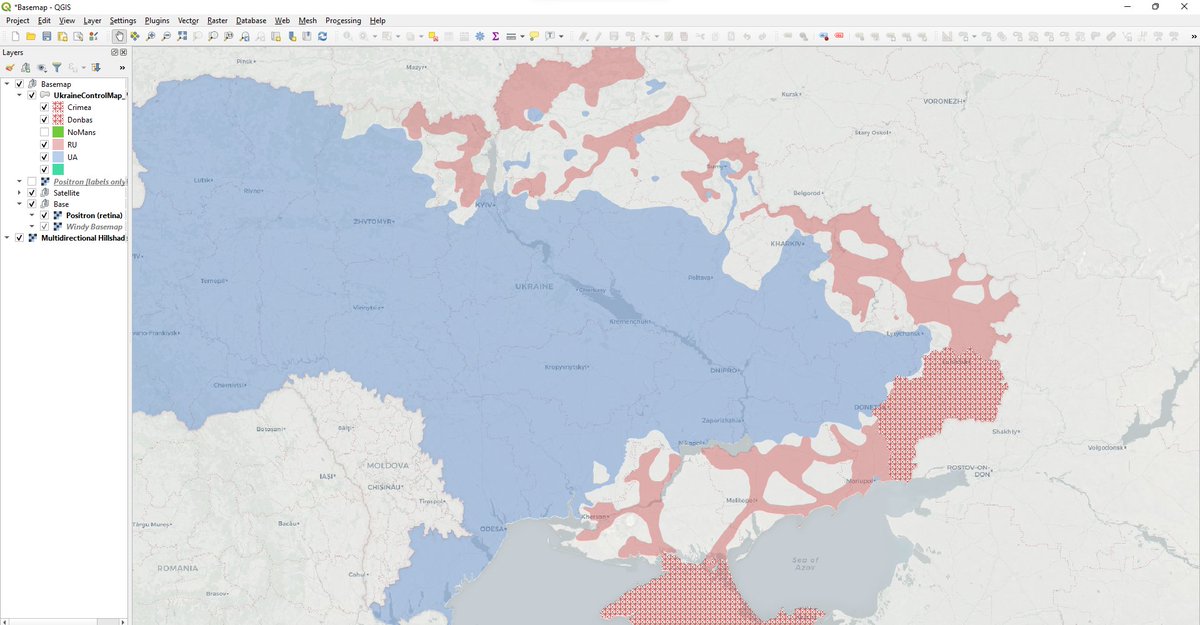
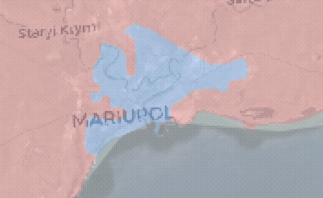
Because of the scale of the base data, some areas are overly generalised and please don't take it as a tactical map at the city level. I have tried to map with as much detail as possible in areas like Mariupol
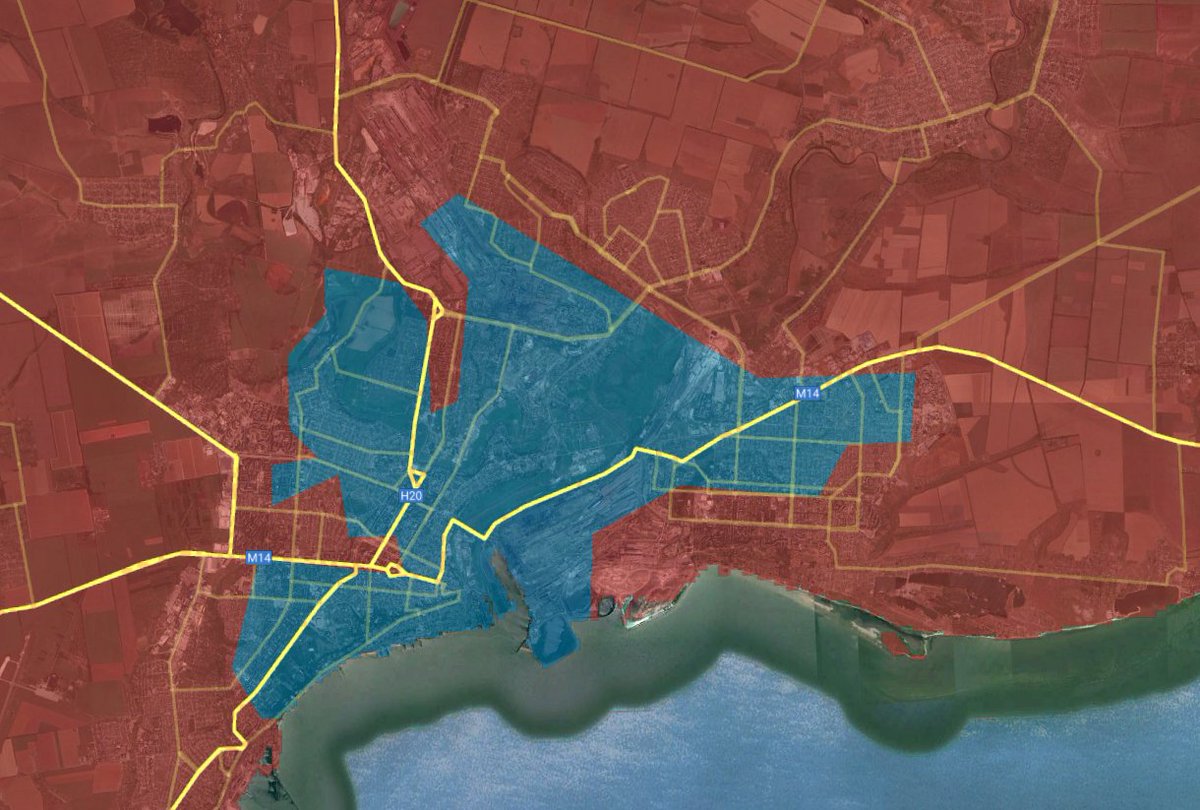
For a more detailed map of these areas please see @Militarylandnet. They have very good and reliable maps.
The difference between the forward line of Russian troops and the areas that I assess to be under their firm control (meaning they are able to prevent the fielding/maneuvering of significant units of enemy forces) is clear in this map, so are the difficulties for Russian troops.

Early on in this war, I was publishing maps that only showed Russian troop movements across the countryside, as Russia had not made many attempts to secure the flanks or rear of their positions. This map is still relevant, but a changed Russian strategy makes it less central.

But, it has allowed me to consistently map the progress of Russian soldiers in Ukraine over the 35-days of war. This video shows that progress and subsequent recapture of territory by Ukraine (please view in full screen as some early days are less clearly marked).
Or, this map showing the forward line of Russian troops, since March 11th (when I started making these maps).
A number of the changes are the result of more information being available and not necessarily genuine change on that day, so keep that in mind.
A number of the changes are the result of more information being available and not necessarily genuine change on that day, so keep that in mind.
Or, a video showing the areas under control every day since March 22nd. The same disclaimers apply.
I'll put some close-up crops of the key areas in the tweets below.
I'll put some close-up crops of the key areas in the tweets below.
Firstly, a close-up of Kyiv and the axes that Russia is attacking the city from.
(The dates are cropped out, sorry).
Most importantly (imo) you can see Russia's attempts to develop a secure supply route to Brovary that keeps getting harassed and attacked.
(The dates are cropped out, sorry).
Most importantly (imo) you can see Russia's attempts to develop a secure supply route to Brovary that keeps getting harassed and attacked.
Next, the Southern-Front, from Mykoliav to Mariupol. Here, Russia has lost considerable ground around Mykoliav, while starting a new push to Kryvyi Rih, which has now stalled and in parts been repelled.
The slow grind in Mariupol continues.
The slow grind in Mariupol continues.
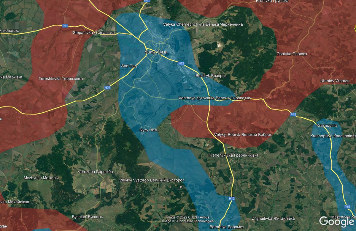
And finally, the Sumy/Kharkiv/Lugansk fronts. In Sumy Russia has recently suffered an almost-complete defeat in the region, lifting the defacto siege on Sumy.
In Kharkiv and Lugansk, Russia has made some recent progress around Izyum and Rubizhne. Some Ukrainian gains too.
In Kharkiv and Lugansk, Russia has made some recent progress around Izyum and Rubizhne. Some Ukrainian gains too.
COVID put me out of action for a few days, so excuse the lack of updates, but as you can see, I was spending my time trying to get a clearer picture of some of the areas where the situation was unclear. I think it is mostly accurate now!
Thanks for reading to here!
Thanks for reading to here!
PS. if anyone wants to georeference the 'forward line' and 'movements' map please DM me and I can send you the full-res files along with a set of GCPs to georeference the raster map!
BTW. Here's a map of all the settlements that have been recaptured by Ukrainian forces so far today.
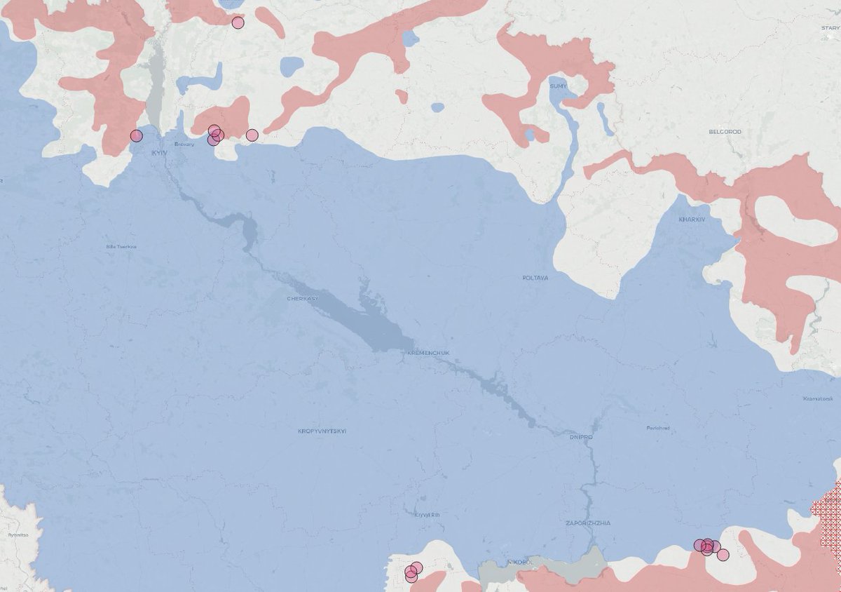
Already adding to that...
• • •
Missing some Tweet in this thread? You can try to
force a refresh