While we have some time, it's time for a severe weather thread on what could be upcoming next week/weekend.
SUMMARY:
Major global models are showing signals of a potent severe threat in the Central US again within the next week.
1/
#uswx #weather #wxtwitter
SUMMARY:
Major global models are showing signals of a potent severe threat in the Central US again within the next week.
1/
#uswx #weather #wxtwitter
(GEFS)
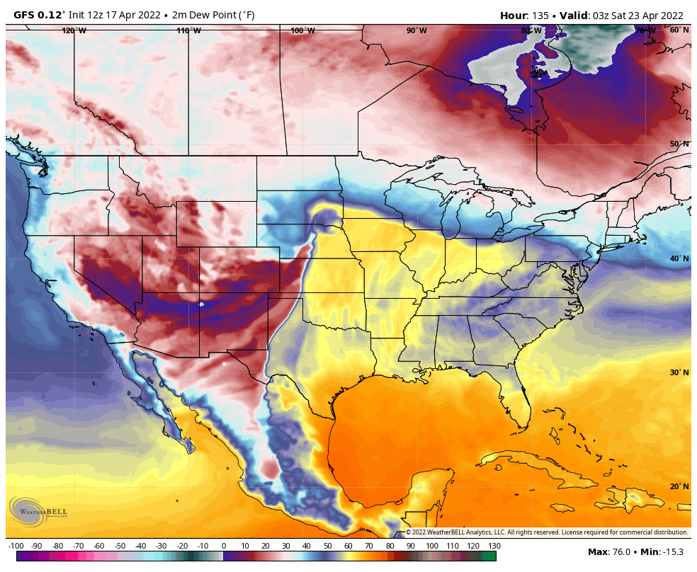
Since our last post, thermodynamics have improved greatly on the deterministic output, in addition, there is way better ensemble agreement with most of them showing much more SigSevere signals.
Overall, thermodynamics and kinematics have improved considerably.
2/


Since our last post, thermodynamics have improved greatly on the deterministic output, in addition, there is way better ensemble agreement with most of them showing much more SigSevere signals.
Overall, thermodynamics and kinematics have improved considerably.
2/


It seems as though that deterministic output is showing some more potential on Saturday than most ensemble members.
However, both outputs are agreeing the major day being Friday the 22nd.
3/
However, both outputs are agreeing the major day being Friday the 22nd.
3/
However, are thermodynamics in general still perfect? No. But, we are still considered in the long-range although in GFS terms, the medium-range.
We could be in for yet another dry-line setup.
4/
We could be in for yet another dry-line setup.
4/

And, if March 5th has taught us ANYTHING, you don't always need 60/70s Dews for a big event, or more specifically strong tornadoes.
Even with this, GFS Deterministic is still going bold Fri afternoon with very high CAPE.
5/
Even with this, GFS Deterministic is still going bold Fri afternoon with very high CAPE.
5/

Overall, from the GFS/GEFS, the signals have become more potent since our last post and we'll continue to watch how these parameters evolve and eventually talk about storm mode.
As we close out the GFS section, we'll leave y'all with a sounding near Omaha, NE.
6/
As we close out the GFS section, we'll leave y'all with a sounding near Omaha, NE.
6/

(ECMWF) Ensemble hasn't even started to render yet, so that will have to come later...
However, 12z Deterministic is out!
So, our whole trough will be similar to the GFS and also slightly slower amplification as it ejects out of the Rockies and into the High Plains.
7/
However, 12z Deterministic is out!
So, our whole trough will be similar to the GFS and also slightly slower amplification as it ejects out of the Rockies and into the High Plains.
7/

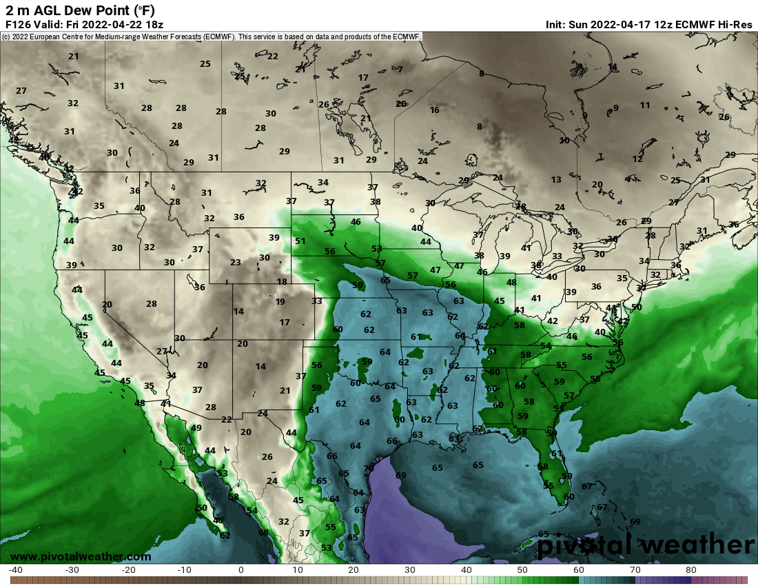
However, while the ECMWF is tagging along with the GFS (or vice-versa) in terms of a potent severe threat, it's overall a bit slower and shows Friday being much further west with Sat-Sun being more potent than what's on the GFS/GEFS.
8/


8/


Thermodynamic wise, the ECMWF is warmer but drier for Fri and cooler for Sat-Sun.
This model is showing low 60s dews for Fri... But with temps in the 80s and some in the 90s (by 21z)!
Sat is cooler with similar dews, but cooler.
9/


This model is showing low 60s dews for Fri... But with temps in the 80s and some in the 90s (by 21z)!
Sat is cooler with similar dews, but cooler.
9/


However, these trends will obviously be monitored as we get closer, and we'll see if agreement/consistency improves.
So far, this forecast is a bit easier than Apr 12th's.
10/
So far, this forecast is a bit easier than Apr 12th's.
10/
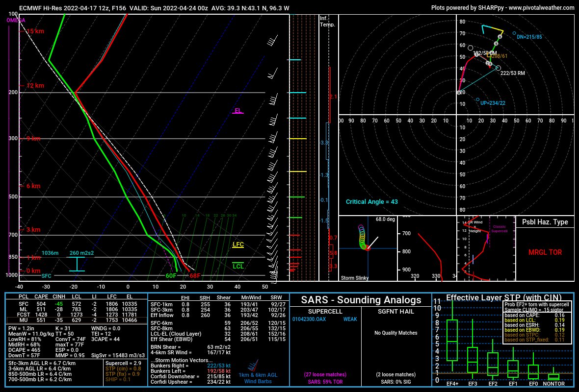
As we close out this whole thread, we'll end with a Euro sounding for both Friday (Left) & Sat-Sun (Right) for the mean/max severe potential areas.
One thing to note, kinematics are pretty clunky, per the usual Euro in the long-range.
11/

One thing to note, kinematics are pretty clunky, per the usual Euro in the long-range.
11/


2 Things:
1.
Fri's Sounding is taken from Western KS & Northwest OK.
Sat's Sounding is taken from Omaha to Kansas City.
2.
Sat appears to have low cape, high shear while Fri is the opposite.
Overall, the Euro has troubles with either kinematics/thermals in the long-range.
12/
1.
Fri's Sounding is taken from Western KS & Northwest OK.
Sat's Sounding is taken from Omaha to Kansas City.
2.
Sat appears to have low cape, high shear while Fri is the opposite.
Overall, the Euro has troubles with either kinematics/thermals in the long-range.
12/
Quick Poll:
Do you enjoy these threads and should we do more?
Or... should we post full articles on our website?
#weather #wxtwitter
Do you enjoy these threads and should we do more?
Or... should we post full articles on our website?
#weather #wxtwitter
• • •
Missing some Tweet in this thread? You can try to
force a refresh


