GeoConfirmed Profile picture
Jun 30, 2022 13 tweets 6 min read Read on X
GeoConfirmed - Thread about the shelling of Snake Island.

I don't think we need to GeoLocate Snake Island anymore, but in case you have doubts, its around 45.254787, 30.203294.

So the claim is that Ukrainian 2S22 Bohdana 155 howitzers were used to shell Snake Island.

1/
This howitzer can fire all standard NATO 155mm ammunition. It has a minimum range of 780m and can fire high-explosive incendiary/armour-piercing (HEIAP) ammunition to a range of up to 42km, and rocket-assisted projectile (RAP) to a range of 50km.

army-technology.com/projects/2s22-…

2/
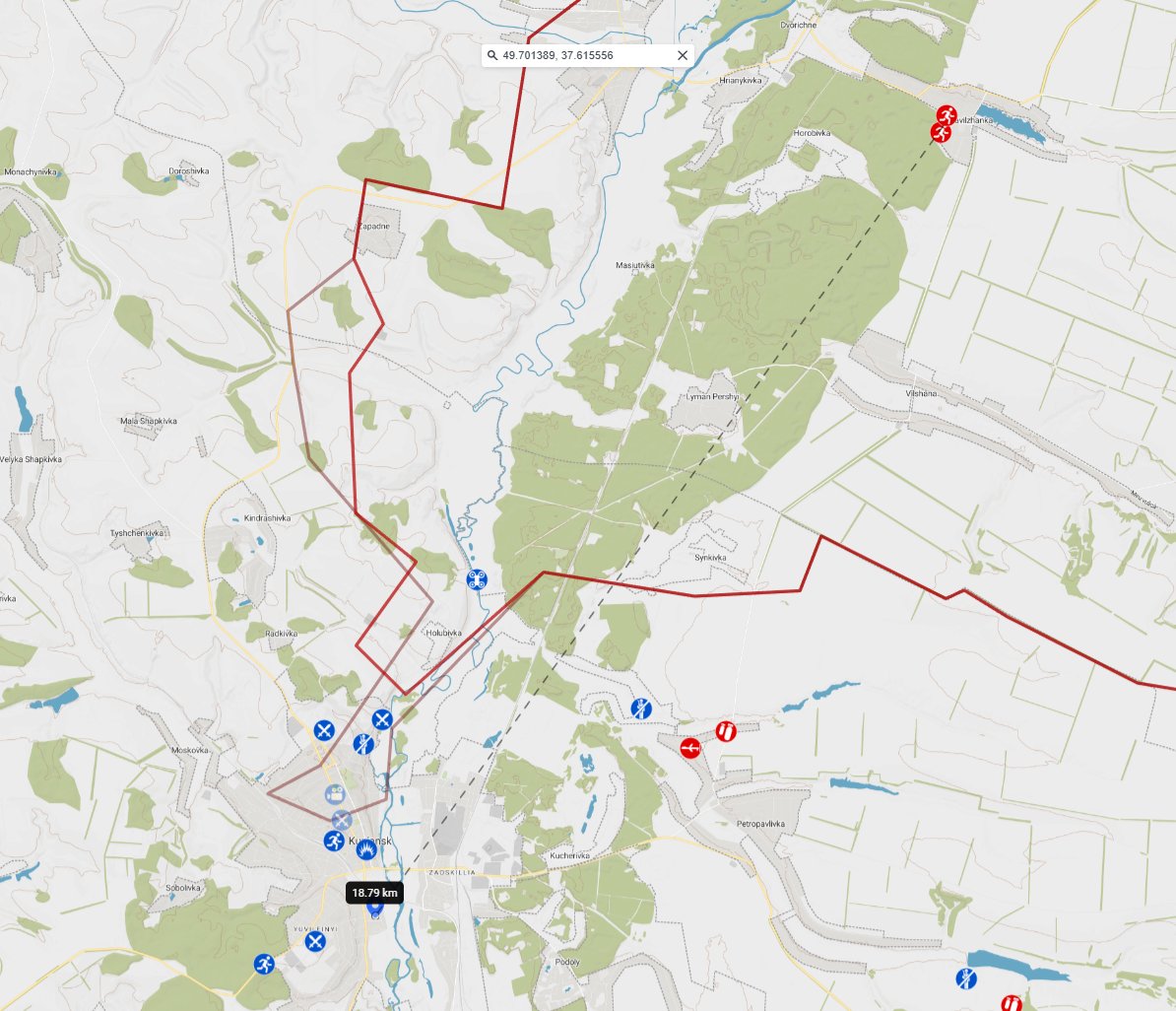
So the range is 42km and 50km. When we project this on Snake Island this is what we get.

3/
But in that area you have something very important: The Romanian border, a NATO country.

So when we cut of the Romanian part of this cone, and we follow the coastline, we get something like this.

4/
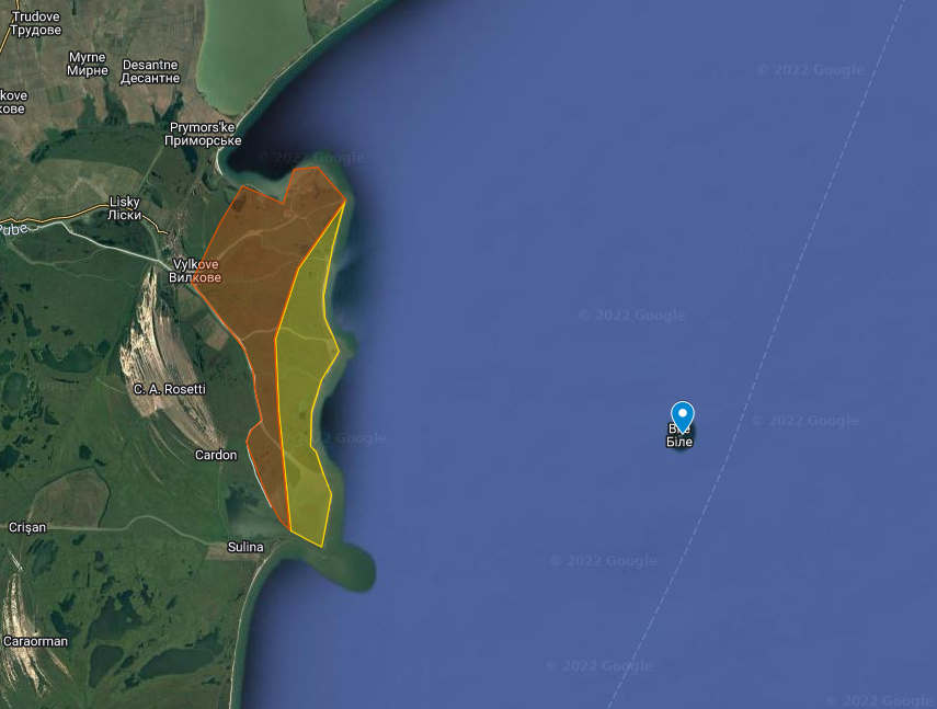
This is an area full of swamps and rivers, and very hard to place heavy artillery. You need a steady ground to fire (and adjust fire). So that limits the options.

But there was another picture:


5/
And yes, we GeoLocated it:

Thx to @AaronB2022 for the initial clue.
And our @GeoConfirmed members @a_vikulin, @kargolow, @OSINT_Amateur searched and found the exact location:

45.301060, 29.752150

6/
So on the map would it be this location:

6,5km from the border of a NATO country.

7/
And how did they get to that location?

Could be by boat, could be by land.

A bridge was build right before 07 MAR between two Island next to the "GeoLocated" Island.

There is also a house with what seems a possible dock near that Island.

8/
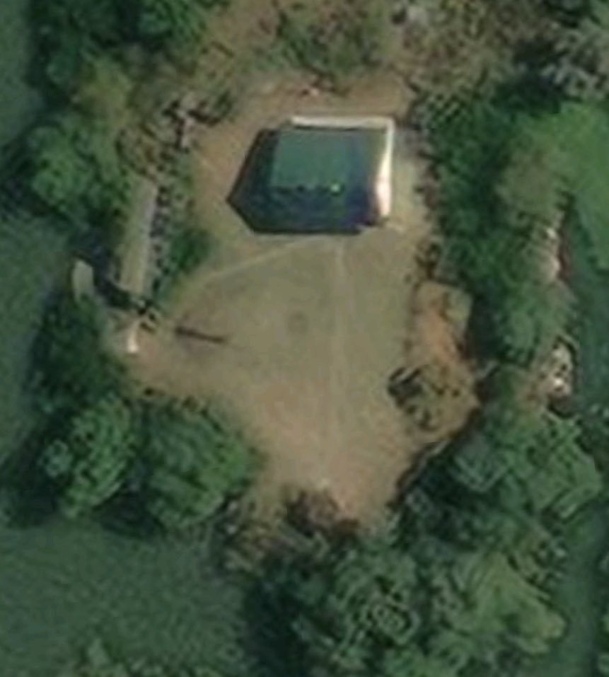
On 25 FEB the Island was overrun, so the building of this -what seems to be- a bridge started soon after the capture of Snake Island. It seems likely that Ukraine was planning all along to shell Snake Island from the coastline.

9/
Conclusion:

It is highly likely that Ukraine indeed used 2S22 Bohdana 155 howitzers to shell Snake Island.

Not only did we geolocate a firing location, Snake Island is also within range for the HEIAP ammunition.

10/
It's also possible that the fact that they fired from an area this close to a NATO country played an important role in the assessment from Russia to not engage it and because of that, they had to withdraw from Snake Island.

11/
Why is Snake Island so important and the loss of it a huge blow for Russia? (Ref. Zoka's reaction)

Because it's a "strategically and tactically important rock" to say it with the words of @CovertShores


12/
Whoever controls the Island, controls all the sea around it.

With the connection Snake Island - Sevastopol you control the access the that part of the Black Sea.

13/

• • •

Missing some Tweet in this thread? You can try to force a refresh
 

Keep Current with GeoConfirmed

GeoConfirmed Profile picture

Stay in touch and get notified when new unrolls are available from this author!

Read all threads

This Thread may be Removed Anytime!

PDF

Twitter may remove this content at anytime! Save it as PDF for later use!

Try unrolling a thread yourself!

how to unroll video
  1. Follow @ThreadReaderApp to mention us!

  2. From a Twitter thread mention us with a keyword "unroll"
@threadreaderapp unroll

Practice here first or read more on our help page!

More from @GeoConfirmed

Apr 29
GeoConfirmed ISR-PAL. GeoConfirmed Investigation 'Mass graves' - Final.

It has come to our attention that our previous investigation thread did not achieve the desired outcome. For this reason, we have conducted further research and wish to clarify some important points:

Although we had intended to demonstrate that the site was not a new mass grave for 180 individuals recently killed by the IDF, as had been insinuated, we underestimated how our initial thread was subsequently used. We did not provide sufficient context, and we now aim to rectify that.

The fact that Palestinians had to bury their loved ones within the hospital complex, in any available space, is a direct consequence of the surrounding and occupation of the hospital by IDF forces. A significant number of the deaths are also the result of the ongoing conflict.

We want to emphasize that open-source intelligence (OSINT) cannot fully capture the extent of what occurred on the hospital grounds.

After our initial investigation, additional questions arose, prompting us to delve deeper into this matter.

Our first thread:
Our temporary update:


We have been able to geolocate dozens of videos.
To make this information more accessible and easier to follow, we have named the three cemeteries based on their respective locations:

Cemetery South
This cemetery is located south of the road, under the palm trees.

Cemetery North
This cemetery is situated north of the road.

Cemetery East
This cemetery is located in the corner of the area.

By naming the cemeteries according to their geographic locations, we aim to provide a more organised and readable presentation of the findings. This approach eliminates the need to include geolocation proof for every individual video, making the information more concise and easier to comprehend.

We will publish our findings in a timely manner to encourage further thought, discussions and investigations on these matters.
This will be a long thread.
The translations were done by using Google translate and Google image translator.

Special thanks to @MiddleEastBuka, @TwistyCB and @GeoRaccoon for their work. Thanks to specific people from outside the GeoConfirmed network for the advice given.

[Every blue pin is a geolocated video between 22 January and now]

001/X
Image
22 January 2024.

One of the earliest reports we found described the dire situation faced by Palestinians during the ongoing siege, where they were forced to bury their dead inside hospital grounds due to the siege of the hospital by IDF.

Source:

"A number of martyrs were buried within the walls of Nasser Hospital due to the occupation’s siege of the hospital, and the martyrs’ families were unable to bury them in the cemeteries."

002/Xt.me/Ahaamd1985/185…Image
Image
22 January 2024.

Cemetery South.
Source:

The martyrs were buried inside the Nasser Medical Complex in Khan Yunis.

003/Xt.me/Ahaamd1985/186…Image
Read 58 tweets
Apr 22
GeoConfirmed ISR-PAL Investigation.

Palestinians are exhuming bodies from the grounds of the Nasser Medical Complex hospital complex in Khan Younis, Gaza.
This is occurring at the same location where mass graves were dug and burial ceremonies had taken place by Palestinians in recent months. (Proof in this thread)

Footage from Palestinians digging graves/mass graves dated 25 January, 28 January and 03 February while IDF entered the hospital around 15 February.

Quote from
“In the hospital courtyard, civil defence members and paramedics have retrieved 180 bodies buried in this mass grave by the Israeli military." (By Al Jazeera’s Hani Mahmoud)

Conclusion:
This is disinformation by Al Jazeera and others:
This is a known graveyard/mass grave and at least partially dug by Palestinians.
This does not exclude that graves could have been added when the hospital was occupied by Israeli forces.aljazeera.com/news/2024/4/21…Image
25 JAN 2024 - Palestinian burials by Palestinian people in Nasser Hospital. (VID 01)

An estimation of 75 graves (3 rows of 25 graves) are visible on this video at the exact place where they claimed to have found a mass grave made by the Israeli military.

31.345841, 34.291887

Source:


t.me/Ahaamd1985/187…
t.me/VBnO4pp1lMzBi/…
Still of the footage in VID 01 showing the source, the date and the estimated 75 graves. Image
Read 25 tweets
Apr 22
GeoConfirmed ISR-PAL Investigation.

Palestinians are exhuming bodies from the grounds of the Nasser Medical Complex hospital complex in Khan Younis, Gaza.
This is occurring at the same location where mass graves were dug and burial ceremonies had taken place by Palestinians in recent months. (Proof in this thread)

Footage from Palestinians digging graves/mass graves dated 25 January, 28 January and 03 February while IDF entered the hospital around 15 February.

Quote from
“In the hospital courtyard, civil defence members and paramedics have retrieved 180 bodies buried in this mass grave by the Israeli military." (By Al Jazeera’s Hani Mahmoud)

Conclusion:
This is disinformation by Al Jazeera and others:
This is a known graveyard/mass grave and at least partially dug by Palestinians.
This does not exclude that graves could have been added when the hospital was occupied by Israeli forces.aljazeera.com/news/2024/4/21…Image
25 JAN 2024 - Palestinian burials by Palestinian people in Nasser Hospital. (VID 01)

An estimation of 75 graves (3 rows of 25 graves) are visible on this video at the exact place where they claimed to have found a mass grave made by the Israeli military.

31.345841, 34.291887

Source:


t.me/Ahaamd1985/187…
t.me/VBnO4pp1lMzBi/…
Still of the footage in VID 01 showing the source, the date and the estimated 75 graves. Image
Read 20 tweets
Apr 5
GeoConfirmed UKR.

Last night, Ukraine executed one of its most extensive combined drone strikes in history, according to preliminary reporting: At least 100 drones were involved in the attacks, targeting at least three areas in Russia: Kursk, Engels Airbase, and Morozovsk Airbase. Additionally, there are reports that Belgorod, Voronezh, and Rostov-on-Don may also have been targeted.

In this thread we will publish the different geolocations.

VID 01:

Air defense working and explosions seen in direction of Morozovsk Air Base.

POV: 48.337652, 41.823166

Geolocated by @auditor_ya
VID 02

Air defence working and explosions seen in direction of Morozovsk air base.

POV: 48.33883, 41.82436

GeoLocated by @Dmojavensis

Read 19 tweets
Mar 13
GeoConfirmed ISR-PAL.

The spreading of misinformation through insinuations is also a well-known tactic. Questions are posed with insinuations in order to sow confusion because the answer is not known. In this case, the hidden insinuation is that it could be a military staged operation. It is NOT.

In this viral tweet with 750k views, 2500 RT's, ... the author asks 4 questions, we will answer them all based on geolocations: a fact.

The geolocation of the footage below is part of our huge GeoConfirmed 7 October Investigation:
Over 400 different captured 'incidents' have been analyzed, with the majority being geolocated and evaluated in terms of both space and time. There are still hundreds remaining to be processed. In the future we will share our investigation with our audience.

The author asks the following questions:

1) Where are these people fleeing from?
2) Why don't the cars match?
3) Why doesn't the landscape match?
4) Why are there no trees?

In short:

1) Hamas militants are shooting at them.
2) Because the drone video (Drone Vid) was recorded 600 meters further than the video of the fleeing civilians. (Vid 01)
3) Because (Vid 01) is recorded 600m away from the road. And even on google maps some very big fields are visible in the area.
4) Because (Vid 01) is taken in a big field.

Of course, in the following thread, we will provide a detailed explanation so that everyone can understand how we were able to answer the questions.

1/xImage
Firstly, we searched for the original videos in our database. We will list them below along with the source. The videos are named "Drone vid" and "Vid 01"

Drone vid:

Footage taken from the entrance towards the festival on the 232 road, filming north.

Grid: 31.397487, 34.472385

GeoLocation:


Sources:


Trackingnumber: 0397

2/x


t.me/southfirstresp…
Location on the map: (Red pin)

3/x Image
Read 12 tweets
Feb 22
GeoConfirmed - Disinformation.

"Ukrainian drone operator dropping grenades on civilians in Donetsk city."

1,5 million views and almost everything is wrong.

It's not in Donetsk city
(but Staromykhailivka, 15km west of Donetsk City, 4km from frontline),

these are not civilians
(but soldiers: they wear weapons and/or have red color bands)

and the footage is almost 1 year old.
(24-26 FEB 2023)

The power of "GeoLocations" and the traceability by the GeoConfirmed map... []
Special thanks to @blinzka who had an idea of the location.

Part 01: 0:00 - 0:15: 47.999461, 37.604027, posted at 26 FEB 2023 by @Gulli_ver_sn and GeoLocated by @neonhandrail

Part 02: 0:16- 0:45: 47.999508, 37.603522, posted at 24 FEB 2023 by @SerDer_Daniels and GeoLocated by @neonhandrail and @smith_1759

1/6geoconfirmed.org/ukraineImage
One original source of video 1: (26 FEB 2023)


Men dressed in camouflage colors with weapons, clearly not civilians.

3/6
Image
Read 6 tweets

Did Thread Reader help you today?

Support us! We are indie developers!


This site is made by just two indie developers on a laptop doing marketing, support and development! Read more about the story.

Become a Premium Member ($3/month or $30/year) and get exclusive features!

Become Premium

Don't want to be a Premium member but still want to support us?

Make a small donation by buying us coffee ($5) or help with server cost ($10)

Donate via Paypal

Or Donate anonymously using crypto!

Ethereum

0xfe58350B80634f60Fa6Dc149a72b4DFbc17D341E copy

Bitcoin

3ATGMxNzCUFzxpMCHL5sWSt4DVtS8UqXpi copy

Thank you for your support!

Follow Us!

:(