Simon Gascoin Profile picture
Jul 22 5 tweets 3 min read
Hé les @decodeurs c'est super d'utiliser #Sentinel2 mais attention il n'y a pas d'image prise le 21 juillet... lemonde.fr/les-decodeurs/…
L'image que vous avez utilisée date du 17 juillet alors que le feu n'avait pas atteint sa surface max. apps.sentinel-hub.com/sentinel-playg…
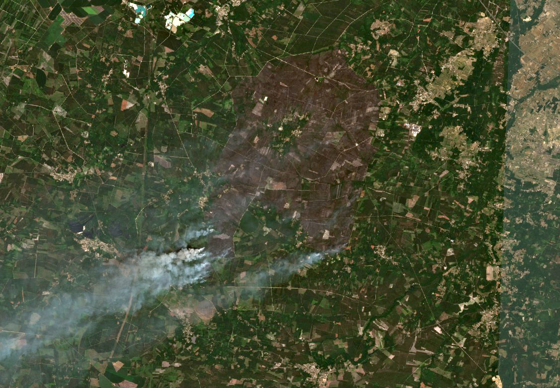
En attendant l'image Sentinel-2 d'aujourd'hui, Il y a une image plus récente prise par Landsat le 19/07 qui montre que la surface a largement progressé depuis le 17/07 malgré les nuages
Votre autre image (avant le feu) date effectivement du 12 juillet
Enfin petit détail ce n'est pas le "satellite Sentinel-2 L2A" mais juste Sentinel-2 ou plus précisément un des deux Sentinel-2A ou Sentinel-2B. "L2A" est le niveau de traitement des images labo.obs-mip.fr/multitemp/les-…

• • •

Missing some Tweet in this thread? You can try to force a refresh
 

Keep Current with Simon Gascoin

Simon Gascoin Profile picture

Stay in touch and get notified when new unrolls are available from this author!

Read all threads

This Thread may be Removed Anytime!

PDF

Twitter may remove this content at anytime! Save it as PDF for later use!

Try unrolling a thread yourself!

how to unroll video
  1. Follow @ThreadReaderApp to mention us!

  2. From a Twitter thread mention us with a keyword "unroll"
@threadreaderapp unroll

Practice here first or read more on our help page!

More from @sgascoin

Jul 22
Comme plusieurs fleuves en Europe, le Rhin s'écoule depuis les Alpes.. Mais quelle est la contribution de la pluie, de la neige et de la glace dans son débit ? #thread
Réponse : ça dépend où et quand.
La contribution de la fonte de la glace est significative (13%) dans un petit cours d'eau comme l'Aare à Brienzwiler. Les glaciers couvrent 15% des 555 km2 de son bassin versant hydrodaten.admin.ch/fr/2019.html
Read 10 tweets
Jul 25, 2018
(1/n) Annotated map of the Xe-Namnoi dam breach. The flood came from a saddle dam breach and followed the Vang Ngao river down to the villages. @CopernicusEU #Laosdam
(2/n) note the Houay Ho lake area has grown due to the heavy rainfalls (but did not collapse)
(3/n) Many flooded areas along the Kong river near Attapeau not caused by the dam failure but probably also due to heavy rainfalls
Read 13 tweets

Did Thread Reader help you today?

Support us! We are indie developers!


This site is made by just two indie developers on a laptop doing marketing, support and development! Read more about the story.

Become a Premium Member ($3/month or $30/year) and get exclusive features!

Become Premium

Don't want to be a Premium member but still want to support us?

Make a small donation by buying us coffee ($5) or help with server cost ($10)

Donate via Paypal

Or Donate anonymously using crypto!

Ethereum

0xfe58350B80634f60Fa6Dc149a72b4DFbc17D341E copy

Bitcoin

3ATGMxNzCUFzxpMCHL5sWSt4DVtS8UqXpi copy

Thank you for your support!

Follow Us on Twitter!

:(