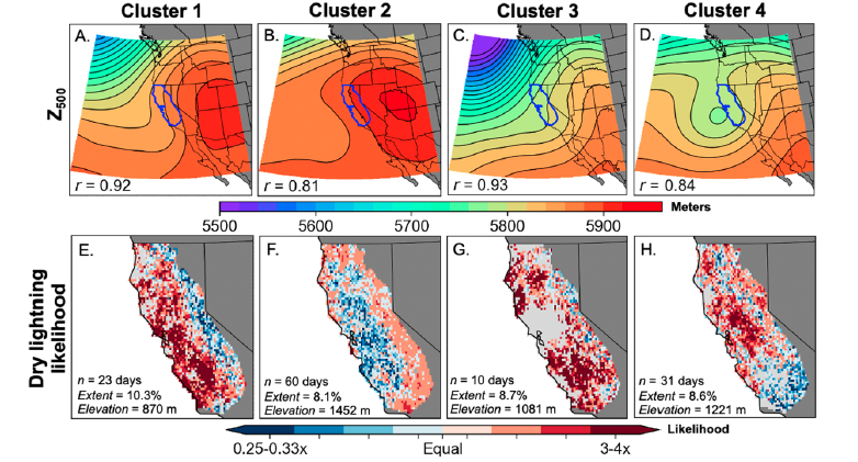
We assess regional-scale atmospheric conditions favorable for dry lightning in central & northern California (N&C CA), as well as seasonality. We find that nearly half of all lightning strikes in N&C CA are "dry" (accompanied by <0.10 in. of rain). (2/n) iopscience.iop.org/article/10.108…
In some locations, including most of the San Francisco Bay Area, North Coast, and portions of Southern Sierra, fully 60-80% of May-Oct cloud-to-ground lightning strikes occur as dry lightning! Major implications for wildfire risk. (3/n) #CAwx#CAfireiopscience.iop.org/article/10.108…
Overall, dry lightning events are most common mid-summer (Jul-Aug), but single largest events historically have actually occurred in shoulder seasons (Jun&Sep). Late-season (Sep-Oct) events preferentially occur in low elev/coastal areas.#CAwx#CAfire (4/n) iopscience.iop.org/article/10.108…
We find that environmental conditions favorable for N&C CA dry lightning events include unusually moist & unstable conditions at mid levels atop dry & unusually hot low levels. High total column moisture does not preclude dry lightning (see:Aug 2020)!(5/n) iopscience.iop.org/article/10.108…
From a regional atmospheric circulation perspective, we find 4 patterns that are broadly conducive to N&C CA dry lightning. All feature high pressure ridging centered to east of CA over continental interior, & 2 of 4 also feature an offshore trough/closed low.#CAwx#CAfire (6/n)
We hope this work will contribute to understanding & predicting dry lightning events in CA given their large implications for wildfire risk, since lightning ignitions often occur in large volume and spread widely across remote areas. #CAwx#CAfire (7/n) iopscience.iop.org/article/10.108…
This is especially true in a warming climate, which is likely increasing the probability of ignition from lightning strikes by causing long-term drying of vegetation and amplifying the potential consequences of those fires that do ignite. (8/8) iopscience.iop.org/article/10.108…
• • •
Missing some Tweet in this thread? You can try to
force a refresh
A few notes on this morning's #Tornado Warning for San Francisco from @NWSBayArea (I am still traveling, so my live interactions are still somewhat limited):
1) Yes, a formal warning was issued by NWS for San Francisco this AM based on a suggestive radar signature. #CAwx [1/7]
@NWSBayArea 2) So far as I know, this was indeed first such warning ever issued for SF proper (but not first tornado in SF!). Other similar warnings have been issued elsewhere in Bay Area under similar conditions (i.e., offshore waterspout potentially moving ashore as tornado). #CAwx [2/7]
@NWSBayArea In 2005, for example, an EF1 tornado occurred in South Francisco, causing some notable damage. Other more significant tornado events have occurred elsewhere in the Bay Area and NorCal; although rare, they are not unprecedented. #CAwx [3/7]sfgate.com/bayarea/articl…
A strong, prolonged, very moist, and relatively warm #AtmosphericRiver event, in conjunction with rapidly-strengthening #BombCyclone (yes, that's the term!), will bring major rain (and, locally, wind) impacts to OR/NorCal this week. Flooding is likely. #CAwx #ORwx #CAwater [1/6]
First, a low pressure system west of OR and WA will undergo explosive deepening (rapid strengthening, known as "bombogenesis") over the next 2 days. It may become one of the strongest low pressure systems on record in this region. (~940mb) #CAwx #ORwx #CAwater [2/6]
This very strong low will generate hurricane-force sustained winds well offshore (& 50-60ft+ waves!). The strongest winds will remain well offshore, but damaging 70-90 mph gusts will still be possible in coastal OR & perhaps along far North Coast of CA. #CAwx #ORwx #CAwater [3/6]
Signs of some "big time" weather for TBD portions of U.S. West coast over next 10 days. A major #AtmosphericRiver, & perhaps a short sequence of very wet ARs, will affect some section of coast between NorCal & WA--perhaps bringing very heavy rain accumulations. #CAwx #ORwx [1/6]
First, it's important to consider the broader context. This autumn to date has been very (anomalously) dry across most of CA (except for far northern parts of state), but much less so in PacNW. It has also been broadly warmer than average across the West. #CAwx #ORwx [2/6]
In around 5 days, upstream Rossby wave breaking over the central North Pacific will set up a favorable pattern for cyclogenesis (storm development) in a position that will likely allow a strong #AtmosphericRiver to develop, likely tapping subtropical moisture. #CAwx #ORwx [3/6]
We are witnessing a genuinely extraordinary, and regionally quite deadly and destructive, period for extreme #weather in the United States. And, quite frankly, the fingerprints of #ClimateChange are all over what has transpired in recent weeks and may yet occur in coming days.
An incredible, ongoing, & increasingly record-shattering heatwave has plagued much of Southwestern U.S. for *weeks* now. Phoenix has now seen *2 consecutive weeks* with record temperatures *every day.* Many other locations have set new Oct and/or "heat streak" records.#CAwx #AZwx
Hurricane #Helene, which intensified very rapidly before making landfall in Florida's Big Bend, bringing record 15+ foot storm surge, then brought an even greater disaster in form of widespread, catastrophic flooding in Southern Appalachians. Hundreds are dead. #NCwx #TNwx #SCwx
The images and stories just beginning to emerge from eastern TN and western NC in the aftermath of widespread catastrophic flooding wrought by #Helene are genuinely horrifying, and the full scale of the disaster is likely as yet untold. #TNwx #NCwx [Thread: 1/n]
20-30 inches--and perhaps locally 40+ inches--of rain fell along highest ridges of the Southern Appalachians due to 1-2 punch consisting of extreme "predecessor rain event" (PRE) that was historic in its own right followed by further extreme rain directly from #Helene. [2/n]
This was, by far, the most extreme rain event in observed record across much/most of the region, where reliable records date back over 100 yrs. Unsurprisingly, the flooding which resulted has also been widespread, historic, and generally catastrophic across a broad region. [3/n]
For the first time since June in many parts of California and the broader Southwest, *cooler* than average temperatures can be expected for the next week, thanks in part to arrival of a *second* anomalously deep August low pressure system over NorCal Thu/Fri. #CAwx [1/4]
Another round of widespread rain & possible t-storms will occur in western WA & OR. In far NorCal, esp. northern mtns (Shasta region), some decent showers & t-storms are possible. Few showers/isolated thunder may reach farther south than last event--locally to I-80 corridor. #ORwx #WAwx #CAwx [2/4]
All of this will be fortuitous for fire season in western Washington and Oregon--mainly west of Cascades. While active fires will continue to east of Cascades, this may be season-ending precip (or close to it) for western WA and NW OR. #ORwx #WAwx [3/4]