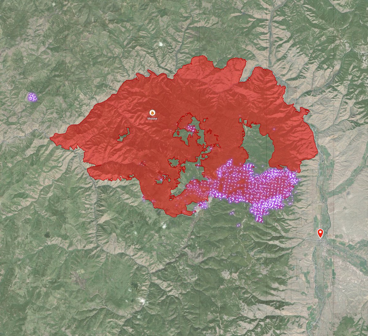
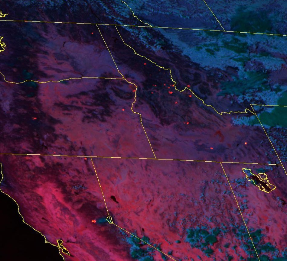
2) we're still hours away from the next higher-res VIIRS 🛰️pass. The latest (good) data I have is from 3:30p (left) and lower res MODIS from 10:30p (right) which doesn't show much heat at all. 🧵
3) if you've seen rumors about Galena & fire in the wood river valley, see this previous thread (I see no evidence for it) and the 10:30 MODIS doesn't support that either.
4) I'm anxiously awaiting the nightly IR Mapping mission data for #MooseFire and #RossForkFire to confirm growth. N149Z is currently on the North Idaho fires, will pit stop in Missoula in about 30, then resume its mission of central Idaho fires. Should wrap up around 4am. 🧵
5) new expanded #TFR in place.
I saw one or two unrelated planes in transit the TFR or skirting the S edge of fire today, so this should give them more breathing room.
🧵
6) #RossForkFire has already cooled off more tonight than it ever did last night. Here's the GOES-west fire temp channel animation. (last night's is in my feed)
side note: The Trail Ridge fire at Lost Trail really went nuclear today based on earlier data from this sat
7) I was really hoping to have tonight's ICS-209 incident summary to look over, but the gbcc hasn't posted them yet. Will take a fresh look at everything in the morning.
8) the incoming Incident Management Team (Type-2) takes over in the morning. IMTs have their own PIO staff so we should start getting a little more consistent information with additional resources there.
9) and... that's a wrap for me today. I'll hop on and post/comment on maps & sit rep in the morning as soon as the data is available. G'night y'all.
• • •
Missing some Tweet in this thread? You can try to
force a refresh
Alright, been a busy real job day, but finally time for a #MooseFire update thread. This will be a slow thread, I'll post things as I go through different data sources.
The fire is listed at ~125k acres, growing just over 2k acres yesterday.
🧵I'm only going to focus on the fire as it relates to threatening Salmon. Elsewhere, the fire isn't doing much. Here's today's official PIO map. (I'll call out any official maps I use)
🧵 here's a wider look at MODIS/VIIRS fire detections over the last 24 hours along with perimeter. Most heat is around Leesburg and E towards Salmon.
As of a few minutes, ago, Southern Idaho Interagency Dispatch logs confirm they are working an Initial Attack Fire near Cherry Creek just south of Galena Lodge. Fire doesn't have a name yet.
The Galena area is now under a "SET" evacuation status.
Alright, we're heading into the evening. Been away from twitter doing the thing that pays the bills for a bit. about to take a look at recent fire info.
I'm anxiously awaiting fresh satellite data for the moose fire. Until then, I don't have anything of substance to add. Salmon is smoked in, can't see a damn thing.
NEW IR DATA! #MooseFire
This is from the nightly IR Mapping flight, which overflew the fire a couple hours ago at approx 12:15am
Red is previous IR perimeter (which was a very controlled fire weeks ago)
Yellow & Orange are the current blowup
(I'll 🧵 a closer look and comments)
🧵a closer look at fresh IR data shows fire approaching sagebrush in Wallace creek and *just* barely into Jesse creek (Salmon's municipal water source)
It does not appear that fire has crossed the powerline to the south.
I'm *guessing* fire crews will meet the fire at diamond creek road for burnouts. And if weather/visibility permits, I can imagine AM tanker support between fairgrounds and town.
Red flag warning tomorrow... this ain't over.
Ok, let me put on my optimistic hat for a moment for #MooseFire and then, I'm going to do something I try not to do. Speculate. a🧵
First, here's the most recent 🛰️ pass of Tera (MODIS) as of 20 minutes ago.
It shows fire well-established E of contingency line. But (optimistic hat) not well established in Jesse Creek drainage. Jesse creek is the town's municipal water supply.
We're seeing a significant change in fire behavior.
it's still *VERY* active, crowning, touching etc.
BUT! (optimistic hat)
it's not a wall of 300' flames like we saw when it crossed the contingency line.
(gonna be a slow thread, juggling a lot, lets look at a map)