Zeb Palmer Profile picture
Sep 8 6 tweets 3 min read
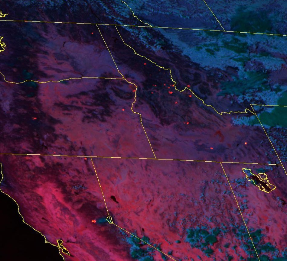
NEW IR DATA! #MooseFire
This is from the nightly IR Mapping flight, which overflew the fire a couple hours ago at approx 12:15am
Red is previous IR perimeter (which was a very controlled fire weeks ago)
Yellow & Orange are the current blowup
(I'll 🧵 a closer look and comments)
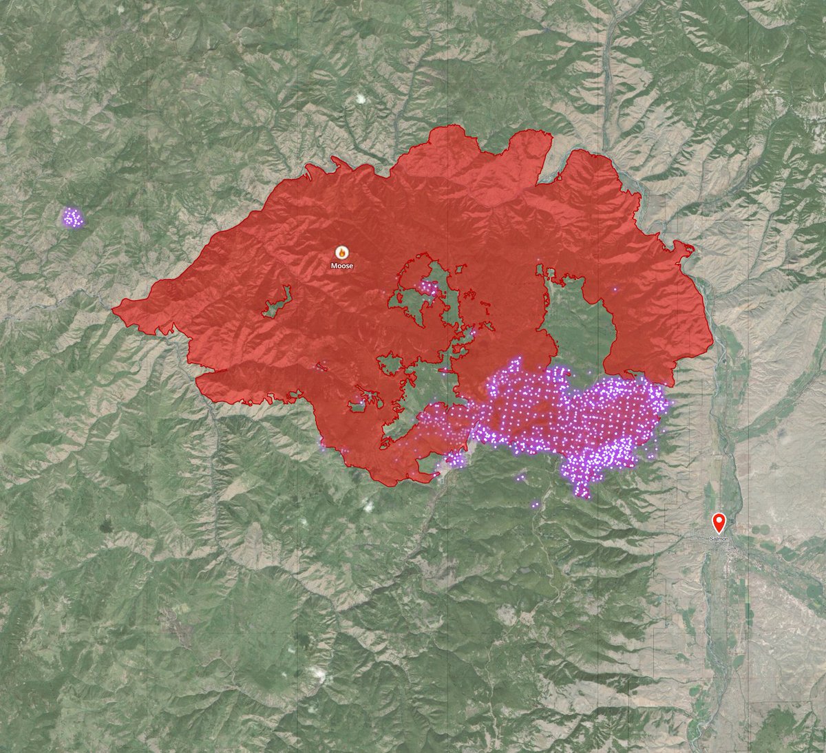
🧵a closer look at fresh IR data shows fire approaching sagebrush in Wallace creek and *just* barely into Jesse creek (Salmon's municipal water source)
It does not appear that fire has crossed the powerline to the south.
I'm *guessing* fire crews will meet the fire at diamond creek road for burnouts. And if weather/visibility permits, I can imagine AM tanker support between fairgrounds and town.
Red flag warning tomorrow... this ain't over.
But, as far as scenarios where a 4-mile-long fire front jumps the ridge road contingency line... *currently* this looks a ton less bleak than it did at 11pm. Still, very bad. And could get *much* worse.
breathe...
Had questions a few hours ago about Beartrack Mine & Leesburg. #MooseFire
Looks like the fire crossed the 300 road at the north end of the site. I don't see anything that would make me suspect a loss of structures.
Here's a 3D look (looking N) of the Ridge Road Contingency line, the 4-mile section where the wall-o-fire jumped it.
This line was started in 2000 during the Clear Creek Fire. Saw lots of improvement during the Mustang Fire and again now with #MooseFire

• • •

Missing some Tweet in this thread? You can try to force a refresh
 

Keep Current with Zeb Palmer

Zeb Palmer Profile picture

Stay in touch and get notified when new unrolls are available from this author!

Read all threads

This Thread may be Removed Anytime!

PDF

Twitter may remove this content at anytime! Save it as PDF for later use!

Try unrolling a thread yourself!

how to unroll video
  1. Follow @ThreadReaderApp to mention us!

  2. From a Twitter thread mention us with a keyword "unroll"
@threadreaderapp unroll

Practice here first or read more on our help page!

More from @zebpalmer

Sep 9
Alright, been a busy real job day, but finally time for a #MooseFire update thread. This will be a slow thread, I'll post things as I go through different data sources.
The fire is listed at ~125k acres, growing just over 2k acres yesterday.
🧵I'm only going to focus on the fire as it relates to threatening Salmon. Elsewhere, the fire isn't doing much. Here's today's official PIO map. (I'll call out any official maps I use) Image
🧵 here's a wider look at MODIS/VIIRS fire detections over the last 24 hours along with perimeter. Most heat is around Leesburg and E towards Salmon. Image
Read 28 tweets
Sep 9
New Fire!

As of a few minutes, ago, Southern Idaho Interagency Dispatch logs confirm they are working an Initial Attack Fire near Cherry Creek just south of Galena Lodge. Fire doesn't have a name yet.

The Galena area is now under a "SET" evacuation status.
wtf, where'd the extra , come from? sigh...
Well, my pin was pretty damn close to where they just marked it 😀 Image
Read 5 tweets
Sep 8
Alright, we're heading into the evening. Been away from twitter doing the thing that pays the bills for a bit. about to take a look at recent fire info.
TLDR: everything is still burning... Several new fires from last night and this morning. A lot of heat in central Idaho & surrounding area right now.
#MooseFire #RossForkFire #RainbowFire #FourCornersFire #TrailRidgeFire #AllTheOtherFires ImageImage
I'm anxiously awaiting fresh satellite data for the moose fire. Until then, I don't have anything of substance to add. Salmon is smoked in, can't see a damn thing.
Read 6 tweets
Sep 8
Ok, let me put on my optimistic hat for a moment for #MooseFire and then, I'm going to do something I try not to do. Speculate. a🧵

First, here's the most recent 🛰️ pass of Tera (MODIS) as of 20 minutes ago. Image
It shows fire well-established E of contingency line. But (optimistic hat) not well established in Jesse Creek drainage. Jesse creek is the town's municipal water supply.
We're seeing a significant change in fire behavior.
it's still *VERY* active, crowning, touching etc.
BUT! (optimistic hat)
it's not a wall of 300' flames like we saw when it crossed the contingency line.
(gonna be a slow thread, juggling a lot, lets look at a map)
Read 12 tweets
Sep 8
**BREAKING**

#MooseFire HAS CROSSED THE RIDGE ROAD FIRE BREAK. CROWN FIRE VISIBLE FROM SALMON

This is the scenario we've been dreading for decades. Image
Fire crews will be preparing to light burnouts on the edge of Salmon. This is a worst-case scenario.
#MooseFire approaching salmon now. Uploading video, will post shortly. Image
Read 4 tweets
Sep 8
"Unfortunately, the ridge road isn't a good position to hold this fire... If it does cross the ridge road, we will be downslope towards Salmon burning above the homes to protect Salmon"

Rough quote from #MooseFire briefing moments ago. 1/2🧵
This basically means, in this weather, it's not safe for crews to try to hold the ridge road fuel break & I agree.

We're at a real risk of losing Salmon's municipal water source tonight. It's up to the wind at this point.
**Confirmation**

#MooseFire Incident Commander:

"The fire crossed the 300 road a little north of Bear track mine, honestly we don't know know what the rest of the 300 road looks like. We can't even fly it right now."

(I'll continue the 🧵)
Read 4 tweets

Did Thread Reader help you today?

Support us! We are indie developers!


This site is made by just two indie developers on a laptop doing marketing, support and development! Read more about the story.

Become a Premium Member ($3/month or $30/year) and get exclusive features!

Become Premium

Don't want to be a Premium member but still want to support us?

Make a small donation by buying us coffee ($5) or help with server cost ($10)

Donate via Paypal

Or Donate anonymously using crypto!

Ethereum

0xfe58350B80634f60Fa6Dc149a72b4DFbc17D341E copy

Bitcoin

3ATGMxNzCUFzxpMCHL5sWSt4DVtS8UqXpi copy

Thank you for your support!

Follow Us on Twitter!

:(