Alright, been a busy real job day, but finally time for a #MooseFire update thread. This will be a slow thread, I'll post things as I go through different data sources.
The fire is listed at ~125k acres, growing just over 2k acres yesterday.
The fire is listed at ~125k acres, growing just over 2k acres yesterday.
🧵I'm only going to focus on the fire as it relates to threatening Salmon. Elsewhere, the fire isn't doing much. Here's today's official PIO map. (I'll call out any official maps I use) 

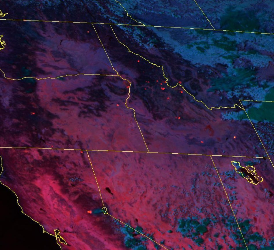
🧵 here's a wider look at MODIS/VIIRS fire detections over the last 24 hours along with perimeter. Most heat is around Leesburg and E towards Salmon.
🧵And I know you'll ask about that cluster on the W side of the fire. that's #OwlFire north of the Salmon River. Last I heard, this fire was not staffed due to lack of resources, a Type 3 IMT is on order to mange it.

🧵 #OwlFire was last listed at 20 acres, based on recent sat data I'm guessing now closer to 100-150 but it hasn't had an IR mapping flight so 🤷♂️
It's inside Mustang 2012 and on edge of Cove Creek 2019 fires. Not threatening anything at the moment.
It's inside Mustang 2012 and on edge of Cove Creek 2019 fires. Not threatening anything at the moment.


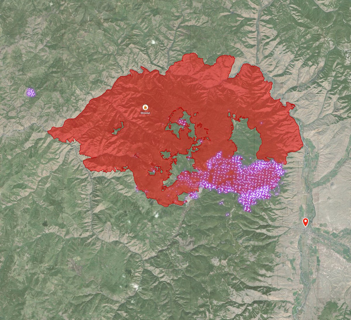
🧵now, back to #MooseFire I'm going to dive into this area, the area that had the 8-mile, 15k acre run.

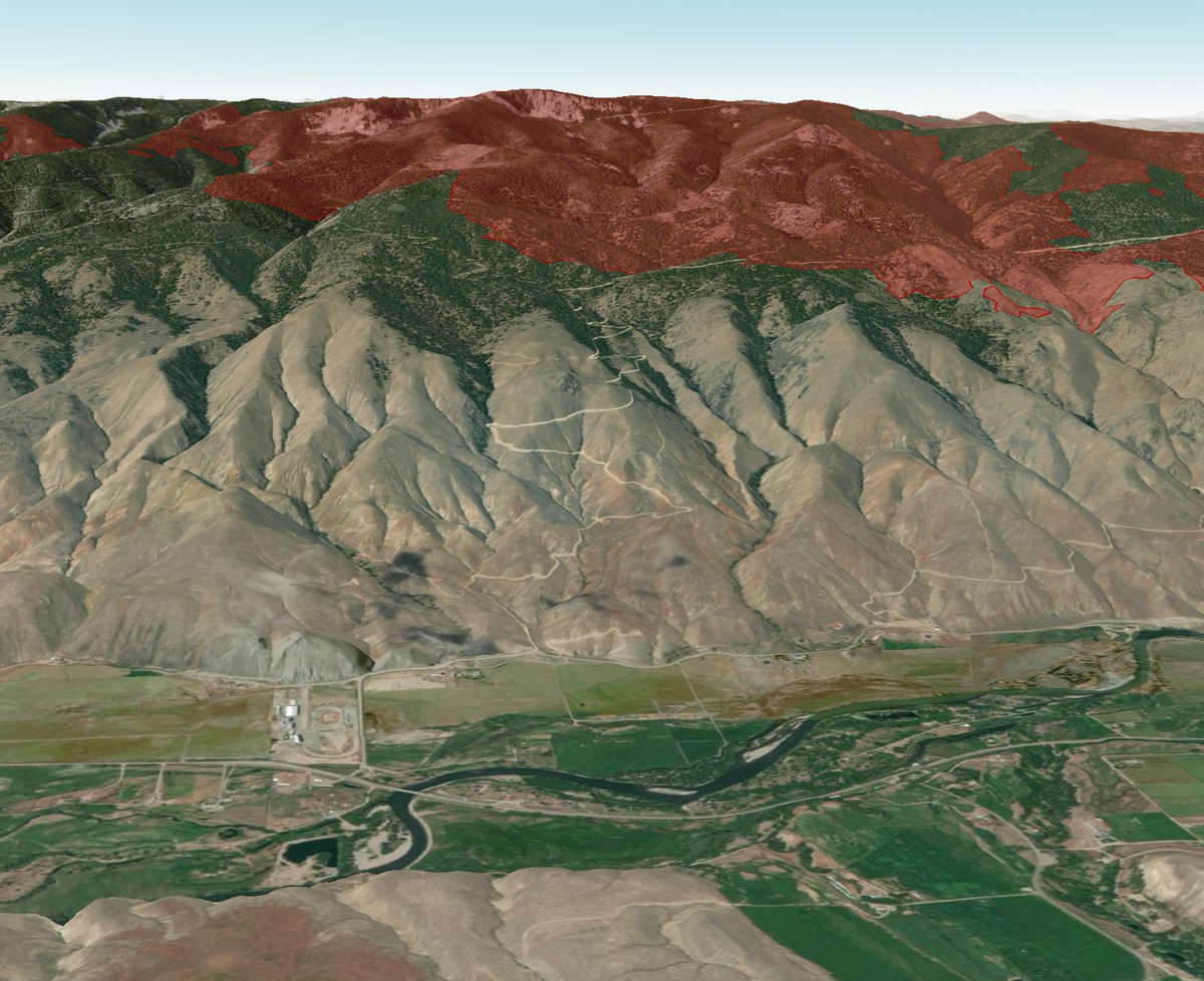
🧵3D map, looking WSW. The fire did cross the powerline to the South. Establishing in the Jesse creek drainage. This was expected. Having fire in the city's water supply isn't ideal, but as the city manager explained, yesterday in a call, they can deal with the after-effects.

🧵here's a 3D look at the fire as seen from Salmon, and another a seen from the Carmen area. Main concern is fire growth to the S & E towards Salmon. The fire burned the area north of here over a month ago.

Alright, I'm going to post this 🧵 now as it's getting long and I don't want to lose it. give me a few minutes, and I'll continue this thread going back to official maps & briefings.
Continuing the #MooseFire 🧵
I meant to post the official progression map earlier, but here ya go. This fire has been around for a while... keep in mind it is human-caused (active federal investigation) and two firefighters (pilots) have been killed fighting it.
I meant to post the official progression map earlier, but here ya go. This fire has been around for a while... keep in mind it is human-caused (active federal investigation) and two firefighters (pilots) have been killed fighting it.

🧵I'll step on my soapbox for a moment to say, everything I've seen from day one shows me fire managers have been doing everything possible to stop this fire. It's been the #1 priority in the nation for much of it's history, #1 in the region for most of that time.
🧵 I haven't been a USFS employee for over 15 years, and as salmon is my hometown and I spend a lot of time in the area, I'd call BS if needed.
🧵this fire jumped TWO very wide dozer contingency lines/fuel breaks in its 8+ mile run towards salmon.
You can't do a damn thing to stop a fire with 55mph+ winds behind it.
Soapbox over....
You can't do a damn thing to stop a fire with 55mph+ winds behind it.
Soapbox over....
🧵here's the current evacuation status map.
Fairgrounds/diamond area are under evac order.
top of the bar (that's the hill half of salmon is on) is on ready status.
Fairgrounds/diamond area are under evac order.
top of the bar (that's the hill half of salmon is on) is on ready status.

🧵current focus appears to be an all-hands-on-deck effort to keep the fire from moving South or East into residential areas.
🧵Another goal is to reduce the intensity of fire in the municipal watershed.
They can't prevent it from burning. But _may_ be able to ensure it isn't scorched earth when done.
Honestly, they're damned if they try damned if they don't.
They can't prevent it from burning. But _may_ be able to ensure it isn't scorched earth when done.
Honestly, they're damned if they try damned if they don't.
🧵this would look like nighttime drone ignition operations to using scattered low-intensity fire to ensure a large crown fire doesn't establish and run through there and sterilize the soil taking decades to recover.
🧵One more break and then I'll be back to look at the fire lines currently being constructed and wrap up.
🧵they're working on fire lines (mostly) in the sagebrush where they can engage with lower intensity fire. The energy release potential in trees is at a record high & 100-hour fuel moisture is at record lows.
basically, explosive conditions.
basically, explosive conditions.
🧵So here's a big picture (my VERY rough map) at where they're working. They're building line from diamond creek past (above) town out to the power line that runs up to Baldy (not to be confused with power line to leesburg / panther creek) where it ties in with Williams creek rd

🧵we can see the portion from Diamond creek road (tying into area that burned a month ago) along the edge of the foothills to Salmon is largely completed using (mixed methods) on their morning map.

🧵They also have hand line from the water facility over to pollard creek.

🧵And according to recent briefings they are scouting lines from the top of Salmon out to the Williams creek area to tie in with the Baldy power line &/or spring creek road / Williams creek road. I'd expect those to be in progress today or tomorrow.

🧵These lines being in in sagebrush means they are quicker to build and lower fire intensity means they're easier to hold. They are also easy places to conduct burnout operations to make the lines even stronger.

🧵The fire will transition back to a Type 1 Incident Management Team tomorrow. The incoming team has been on this fire previously, so they know what they're walking into better than most.
🧵Also worth pointing out, we can't rule out another fire blowup causing fire to cross the ridge road in another spot around Jesse creek or Perreau Meadows. I find that unlikely in the foreseeable weather pattern, but it's not impossible.
🧵and here's the official #MooseFire daily update

Alright, I think that's all I have to say about moose today.
• • •
Missing some Tweet in this thread? You can try to
force a refresh