Take advantage of the good weather today to finish up your hurricane preparations.
Major Hurricane Ian Potential Local Impacts:
☔️ Widespread flooding rainfall
🌬️ TS winds/Hurricane gusts
🌊 Moderate Storm Surge
🌪️ Tornadoes
weather.gov/srh/tropical?o…
#flwx #gawx #jaxwx
Major Hurricane Ian Potential Local Impacts:
☔️ Widespread flooding rainfall
🌬️ TS winds/Hurricane gusts
🌊 Moderate Storm Surge
🌪️ Tornadoes
weather.gov/srh/tropical?o…
#flwx #gawx #jaxwx

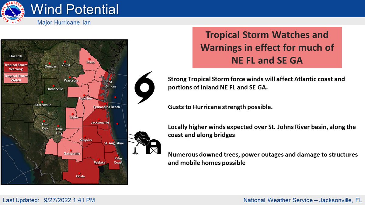
🌀𝐓𝐫𝐨𝐩𝐢𝐜𝐚𝐥 𝐒𝐭𝐨𝐫𝐦 𝐖𝐚𝐭𝐜𝐡𝐞𝐬 & 𝐖𝐚𝐫𝐧𝐢𝐧𝐠𝐬 in Effect for Atlantic coast & portions of inland NE FL & SE GA
🌬️ Strong TS winds with gusts up to hurricane strength possible.
Downed trees 💨🌳🌴 , power outages🔦, home damage🏘, & impassable roads🛣 possible.
🌬️ Strong TS winds with gusts up to hurricane strength possible.
Downed trees 💨🌳🌴 , power outages🔦, home damage🏘, & impassable roads🛣 possible.

🌀𝐒𝐭𝐨𝐫𝐦 𝐒𝐮𝐫𝐠𝐞 𝐖𝐚𝐭𝐜𝐡𝐞𝐬 𝐚𝐧𝐝 𝐖𝐚𝐫𝐧𝐢𝐧𝐠𝐬 are in effect along the NE FL and SE GA coast, ICWW, and St. Johns River Basin.
🌊 Storm surge is often the greatest threat to life and property from a hurricane.
Moderate storm surge of 3-6 ft possible.
🌊 Storm surge is often the greatest threat to life and property from a hurricane.
Moderate storm surge of 3-6 ft possible.

𝐅𝐥𝐨𝐨𝐝 𝐖𝐚𝐭𝐜𝐡 in effect for much of Northeast FL
💧Storm Total Rainfall 6-12 inches across NE FL and SE GA, locally higher amounts possible mainly in NE FL and along the coast.
Moderate to major river flooding expected.
💧Storm Total Rainfall 6-12 inches across NE FL and SE GA, locally higher amounts possible mainly in NE FL and along the coast.
Moderate to major river flooding expected.

• • •
Missing some Tweet in this thread? You can try to
force a refresh


