NWS Jacksonville Profile picture
Sep 28 โ€ข 4 tweets โ€ข 3 min read
๐ŸŒ€ 9/28 5AM Update Major Hurricane Ian

Potential Local Impacts:
โ˜”๏ธ Extensive & potentially extreme flash & river flooding
๐ŸŒŠ Life-threatening Storm Surge
๐ŸŒฌ๏ธ TS winds/Hurricane gusts
๐ŸŒช๏ธ Tornadoes

Rain has begun to move into our area. Finish up preparations!
#flwx #gawx #jaxwx
๐Ÿ’งTorrential Rainfall & Flash Flooding Potential Today into Friday

Storm Total Rainfall:
* NE FL: 6-12", local 18" rainfall amounts possible
* SE GA: 5-9"

โ˜”๏ธ Widespread flooding rainfall anticipated east of FL HWY 301.

Moderate to major river flooding expected.
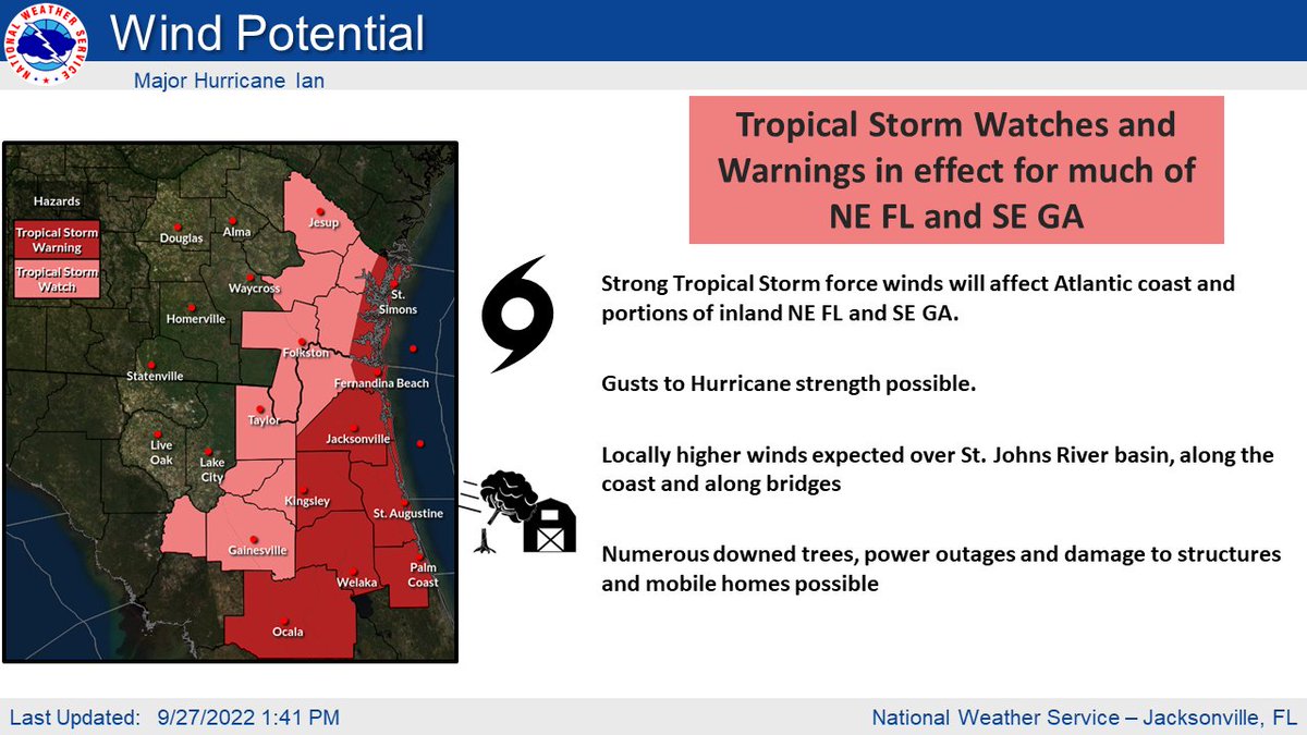
๐ŸŒ€๐“๐ซ๐จ๐ฉ๐ข๐œ๐š๐ฅ ๐’๐ญ๐จ๐ซ๐ฆ ๐–๐š๐ญ๐œ๐ก๐ž๐ฌ & ๐–๐š๐ซ๐ง๐ข๐ง๐ ๐ฌ in Effect for Atlantic coast & portions of inland NE FL & SE GA

๐ŸŒฌ๏ธ Strong TS winds with gusts up to hurricane strength possible.

Downed trees ๐Ÿ’จ๐ŸŒณ๐ŸŒด , power outages๐Ÿ”ฆ, home damage๐Ÿ˜, & impassable roads๐Ÿ›ฃ possible.
๐ŸŒ€๐’๐ญ๐จ๐ซ๐ฆ ๐’๐ฎ๐ซ๐ ๐ž ๐–๐š๐ญ๐œ๐ก๐ž๐ฌ ๐š๐ง๐ ๐–๐š๐ซ๐ง๐ข๐ง๐ ๐ฌ are in effect along the NE FL and SE GA coast, ICWW, and St. Johns River Basin.

๐ŸŒŠ Life-threatening storm surge of 3-5 ft possible.

Moderate to major beach erosion & dangerous boating conditions also expected.

โ€ข โ€ข โ€ข

Missing some Tweet in this thread? You can try to force a refresh
ใ€€

Keep Current with NWS Jacksonville

NWS Jacksonville Profile picture

Stay in touch and get notified when new unrolls are available from this author!

Read all threads

This Thread may be Removed Anytime!

PDF

Twitter may remove this content at anytime! Save it as PDF for later use!

Try unrolling a thread yourself!

how to unroll video
  1. Follow @ThreadReaderApp to mention us!

  2. From a Twitter thread mention us with a keyword "unroll"
@threadreaderapp unroll

Practice here first or read more on our help page!

More from @NWSJacksonville

Sep 28
๐ŸŒ€ Ian is slowly moving NNEward toward the FL Peninsula this afternoon
โš ๏ธ Hurricane Watches now in effect along coastal NE FL & SE GA
๐ŸŒฌ๏ธ Tropical Storm Watches and Warnings remain in effect across much of the area
๐ŸŒŠ Storm Surge Warning along coastal NE FL & SE GA Image
๐ŸŒ€ Strong Tropical Storm force winds will begin to push into north-central FL this evening with Gusts to Hurricane strength along the Atlantic Coast possible tomorrow

๐ŸŒณ Numerous downed trees
๐Ÿ”ฆ Power outages
๐Ÿ˜๏ธ Damage to structures and mobile homes possible Image
๐ŸŒง๏ธ Rounds of heavy rainfall beginning today and lasting through Friday
๐Ÿ“6-15" storm total rainfall, local 18" in NE FL
๐Ÿ“ 5-9" storm total rainfall, locally higher in SE GA Image
Read 4 tweets
Sep 27
Take advantage of the good weather today to finish up your hurricane preparations.

Major Hurricane Ian Potential Local Impacts:
โ˜”๏ธ Widespread flooding rainfall
๐ŸŒฌ๏ธ TS winds/Hurricane gusts
๐ŸŒŠ Moderate Storm Surge
๐ŸŒช๏ธ Tornadoes

weather.gov/srh/tropical?oโ€ฆ

#flwx #gawx #jaxwx Image
๐ŸŒ€๐“๐ซ๐จ๐ฉ๐ข๐œ๐š๐ฅ ๐’๐ญ๐จ๐ซ๐ฆ ๐–๐š๐ญ๐œ๐ก๐ž๐ฌ & ๐–๐š๐ซ๐ง๐ข๐ง๐ ๐ฌ in Effect for Atlantic coast & portions of inland NE FL & SE GA

๐ŸŒฌ๏ธ Strong TS winds with gusts up to hurricane strength possible.

Downed trees ๐Ÿ’จ๐ŸŒณ๐ŸŒด , power outages๐Ÿ”ฆ, home damage๐Ÿ˜, & impassable roads๐Ÿ›ฃ possible. Image
๐ŸŒ€๐’๐ญ๐จ๐ซ๐ฆ ๐’๐ฎ๐ซ๐ ๐ž ๐–๐š๐ญ๐œ๐ก๐ž๐ฌ ๐š๐ง๐ ๐–๐š๐ซ๐ง๐ข๐ง๐ ๐ฌ are in effect along the NE FL and SE GA coast, ICWW, and St. Johns River Basin.

๐ŸŒŠ Storm surge is often the greatest threat to life and property from a hurricane.

Moderate storm surge of 3-6 ft possible. Image
Read 4 tweets
Sep 2, 2019
The 11 AM (9/2/19) update for Hurricane Dorian has the storm about 40-65 miles east of the FL coastline on Wednesday morning. Although the center is off shore, Dorian will yield LIFE THREATENING WAVES, very strong winds, and storm surge along the coastline.
๐ŸŒŠ๐ŸŒŠ๐ŸŒŠ The MAIN THREAT with Dorian will be the life threatening storm surge along the east coast and coastal flooding further inland which will begin AHEAD of the storm.

On top of the inundating water, surf heights of 15 to 25 ft Tue-Wed will batter the coastline.
๐ŸŒ€ The Hurricane Watch (for winds 74+ mph) now covers our entire NE FL and SE GA coastline, with a Tropical Storm Watch (for winds 39-73 mph) for FL counties east of the US-301 corridor.
Read 5 tweets

Did Thread Reader help you today?

Support us! We are indie developers!


This site is made by just two indie developers on a laptop doing marketing, support and development! Read more about the story.

Become a Premium Member ($3/month or $30/year) and get exclusive features!

Become Premium

Don't want to be a Premium member but still want to support us?

Make a small donation by buying us coffee ($5) or help with server cost ($10)

Donate via Paypal

Or Donate anonymously using crypto!

Ethereum

0xfe58350B80634f60Fa6Dc149a72b4DFbc17D341E copy

Bitcoin

3ATGMxNzCUFzxpMCHL5sWSt4DVtS8UqXpi copy

Thank you for your support!

Follow Us on Twitter!

:(