redintelpanda Profile picture
Oct 2, 2022 13 tweets 7 min read Read on X
Thread:

Zvezda News (Russia) dropped a video of a pair of Su-25 attack aircraft "destroying Ukrainian targets."

I've located their departure so far; follow along to see. But first, the video:
Departure base is Dzhankoi Air Base, northern Crimea, from runway 5: 45.704516407968455, 34.42904810893908 ImageImageImage
I've also Geolocated the spot this pair of Russian Su-25's launched rockets from:

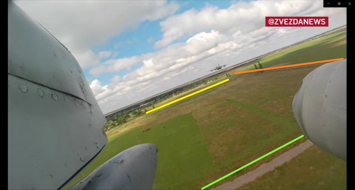
They overflew the village of Bruskynske, Kherson oblast, firing toward or across the Inhulets river.

Pink box is 47.162214, 33.196270:

@GeoConfirmed ImageImageImageImage
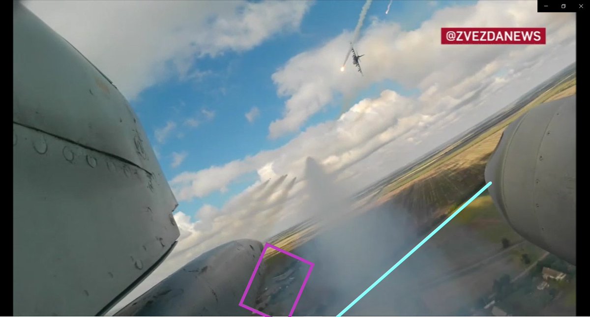
@GeoConfirmed The pair of Russian Su-25's did cross the Dnipro River at about 46.991155, 33.617039 on the way to make their attack run: ImageImage
Video of the Russian Su-25's over Kherson region from this thread archived with details here:

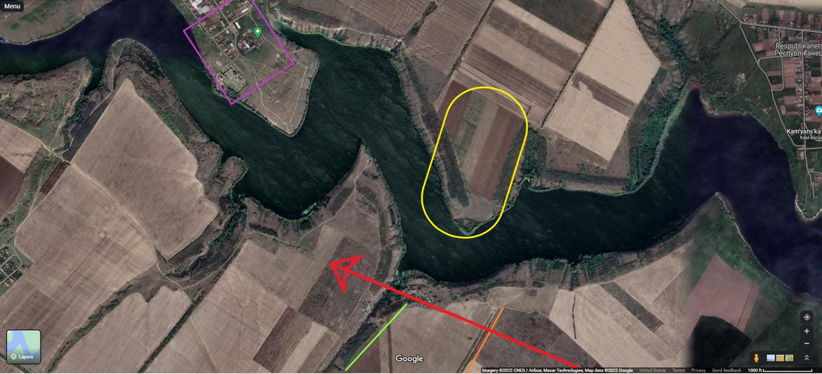
Maps like this show why Russian Su-25's or any attack aircraft, for that matter, were firing on the area of the Kherson front at Davydiv Brid/Bruskynske...

...Ukrainian Army broke through. This tells me the Su-25 video is pretty recent.

Green line added for Su-25 path from vid. Image
This again is the area Russian Su-25s were targeting on Kherson last week and perhaps over the weekend:

More pieces to what is happening on the ground coming together.

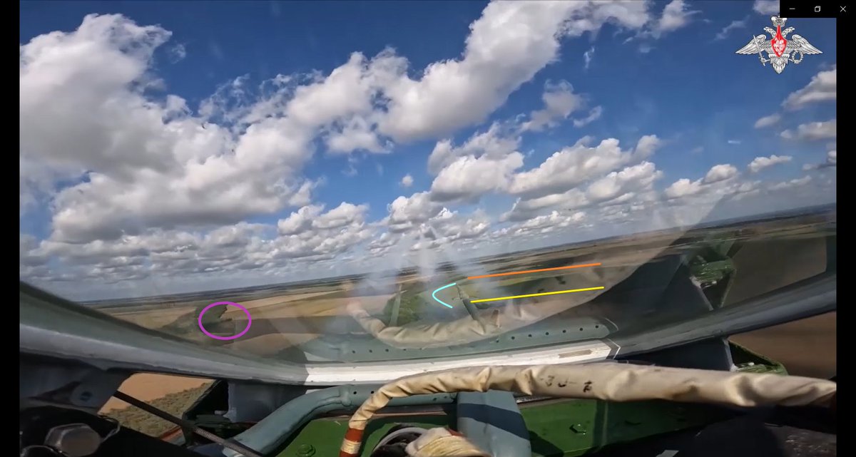
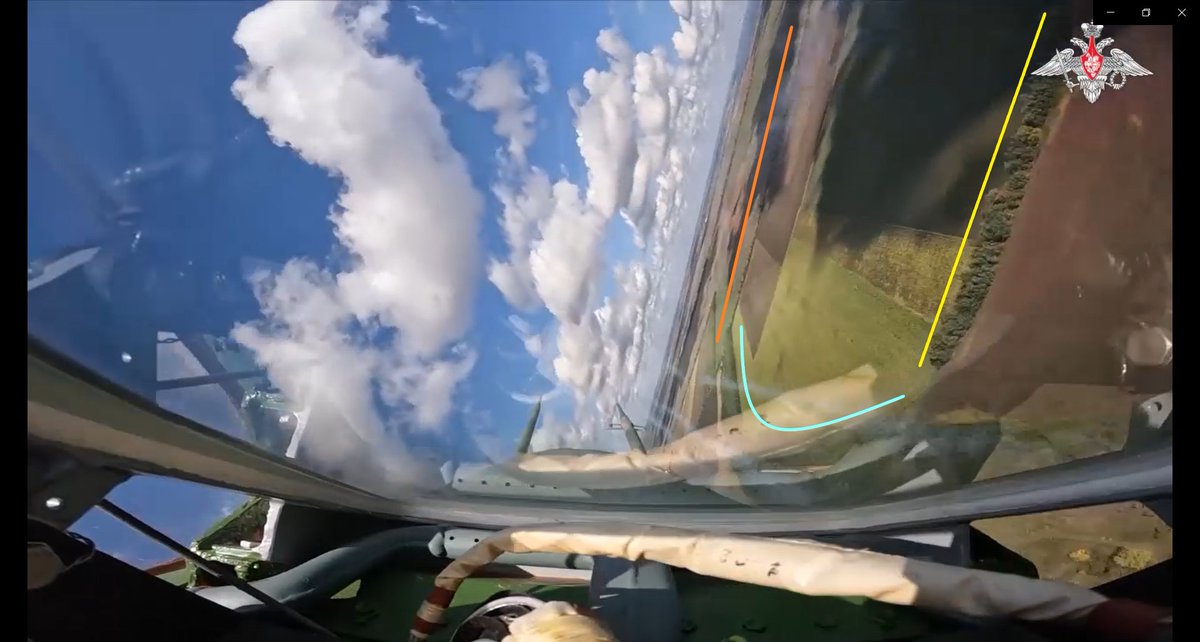
Time again to #Geolocate a Russian Su-25 random rocket run!

Russia MoD released this video showing multiple Su-25's over southern Ukraine.

Their departure point is the same at Dzhankoi, Crimea--see top of this thread.

Here is the video:
#Geolocation:

Kherson front just northwest of Kachkarivka, 47.125110, 33.723288. ImageImageImageImage
Video and location information archived here:

Notable for context that the Su-25's fired toward area of Dudchany, as this map indicates based on the flight path (red line).

General direction of rockets indicated by red arrow, Image
Vitebsk L370 IR jamming pods appear installed:

Sentinel-2 spots of aircraft on 3 and 6 Oct. let us draw a full route for these Russian strike missions on Kherson front.

Both spots are near village of Markeiev, 46.5206660, 34.0485530.

Credit to @bradyafr for these spots and the map!! #OSINT
Image

• • •

Missing some Tweet in this thread? You can try to force a refresh
 

Keep Current with redintelpanda

redintelpanda Profile picture

Stay in touch and get notified when new unrolls are available from this author!

Read all threads

This Thread may be Removed Anytime!

PDF

Twitter may remove this content at anytime! Save it as PDF for later use!

Try unrolling a thread yourself!

how to unroll video
  1. Follow @ThreadReaderApp to mention us!

  2. From a Twitter thread mention us with a keyword "unroll"
@threadreaderapp unroll

Practice here first or read more on our help page!

More from @RedIntelPanda

Apr 29
Thread: Russia is constructing a new airfield about 9km west of the heart of Alexeyevka, a military logistics hub in Belgorod region. In July, 2023 a road was cut to the location, and by the start of winter grading for the runway appeared mostly complete.

50.6612, 38.5694
Image
Image
After the winter thaw, work has resumed. On 27 April 2024 a base layer or paving itself is ongoing on the runway.

The animated image shows this work starting around the beginning of April.
Image
Image
Sentinel Hub measures the runway at about 1800 meters. It is not huge, but can support various types of aircraft. Here is where speculation begins… Image
Read 14 tweets
Oct 7, 2023
Geolocation thread: Shoigu Training Inspection

In this thread I have geolocated where Russian defense minister Shoigu inspected training in the Southern Military District.

Footage is from Telegram, which is the first video John linked below:
@GeoConfirmed @UAControlMap
Shoigu boarded his helicopter at the air base in Rostov on Don. This scene (start 0:01) was on the ramp at approximately 47.27391, 39.63350.

The camera pointed east-southeast, with airfield equipment, fixed-wing aircraft, and large buildings in Rostov on Don visible:
Image
Image
There are two scenes (0:04 and 0:15) showing the helicopter in flight. Both are of the same area, but are out of order in the MoD video. They are northeast of Rostov on Don, crossing a road at 47.41947, 40.00992.
0:15: Approaching Road
0:04: Crossing Road


Image
Image
Image
Image
Read 7 tweets
Jul 22, 2023
Geolocation thread:

Russian Ministry of Defense published this video of a Ka-52 firing a guided missile in Ukraine.

I’ve geolocated where it fired from.

Let’s take a look:

https://t.co/o2WflDwGT8t.me/mod_russia_en/…
This Russian Ka-52 fired its guided missile between Horlivka and Bakhmut, Donetsk region.

It fired over the northern part of Zaitseve village, at 48.43004, 38.02046.

@GeoConfirmed @UAControlMap
Image
Image
Other helicopters that have operated in this area came from the destroyed Luhansk international airport.

While the scenes showing the helicopter taking off and landing do not show landmarks, I have little doubt this Ka-52 is based there.
Image
Image
Read 4 tweets
May 23, 2023
Geolocation Thread:

There is a lot to pull from this short 38 second video from Russian MoD today showing a Ka-52 helicopter in Ukraine.

Let us see what information can be found:

@GeoConfirmed @UAControlMap
First, this Russian Ka-52 helicopter is shown departing Taganrog air base, Russia. This one operates from the southeastern ramp.

Note the metal building at 47.24317, 38.85622 (0:03), and signs along ramp wall at 47.24196, 38.85556 (0:35): ImageImageImageImage
There is one firing point in this video seen by different cameras.

As it pulls up to loft unguided rockets, the forward dash camera caught this mound at 48.00781, 37.64314 (0:26): ImageImageImage
Read 7 tweets
May 23, 2023
Geolocation Thread:

There seem to be few videos of Russian ground attack aircraft from Millerovo air base, Russia.

With heads up from @_davemorrison, two videos sourcing from Russian MoD came out this week.

These are from Telegram and are footage from the same flight: twitter.com/i/web/status/1…
As the Russian Su-25 starts taxiing, you can see the buildings behind the Millerovo ramp at 48.95107, 40.30409.

They have been painted since Google’s imagery of the base.

Time stamp: 0:29 t.me/btr80/7236 ImageImage
On departure the Su-25 pair turned left from Runway 08 westbound toward Ukraine.

Here is that path:

1st image: 0:42 t.me/mod_russia/267…
2nd image: 0:39 t.me/btr80/7236
3rd image: I overlayed the cockpit view to Google Earth. ImageImageImageImage
Read 6 tweets
May 2, 2023
Geolocation investigation:

On 16 February, 2023, the Russian MoD posted this video of rail operations offloading fuel and delivering it “a few kilometers” from the front.

In this thread I locate and expose this MoD bluff.

t.me/mod_russia_en/… @GeoConfirmed @bellingcat
The video begins with tanker trucks receiving fuel from rail tankers via pump trailers.

I did not find these features anywhere near any front in Ukraine--for good reason. All of this was filmed in Alexeyevka, Belgorod region, Russia.

Rail offload: 50.619841, 38.665950 Image
In the last tweet you will notice the windowless building and distinct trees in the background. the camera was looking north.

Here, the camera looks south under a tanker car to see a blue wall across the tracks: Image
Read 8 tweets

Did Thread Reader help you today?

Support us! We are indie developers!


This site is made by just two indie developers on a laptop doing marketing, support and development! Read more about the story.

Become a Premium Member ($3/month or $30/year) and get exclusive features!

Become Premium

Don't want to be a Premium member but still want to support us?

Make a small donation by buying us coffee ($5) or help with server cost ($10)

Donate via Paypal

Or Donate anonymously using crypto!

Ethereum

0xfe58350B80634f60Fa6Dc149a72b4DFbc17D341E copy

Bitcoin

3ATGMxNzCUFzxpMCHL5sWSt4DVtS8UqXpi copy

Thank you for your support!

Follow Us!

:(