Guy Shrubsole Profile picture
Oct 2 6 tweets 4 min read
Govt have today published very worrying new guidance on Investment Zones

Ministers appear willing to consider Investment Zones covering SSSIs & National Parks

And guidance includes mention of "a new streamlined planning system"

#AttackOnNature 1/n

gov.uk/government/pub…
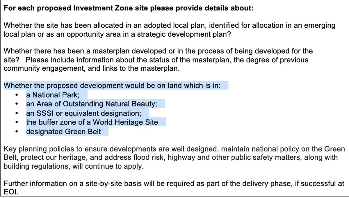
2/n New Expression of Interest form for councils simply asks whether proposed Investment Zones would be on land which is in a National Park, SSSI etc

Nexts para says that various planning policies 'will continue to apply' - but only lists Green Belt & 'heritage', not environment
3/n Elsewhere the EOI form says councils must agree to *mitigate* environmental impacts of the Investment Zone, on or off site.

But there's no mention of *avoiding* environmental impacts in choice of siting - pretty significant if Zone is in an SSSI, SAC, National Park etc!
4/n Meanwhile the Investment Zone guidance is littered with mentions of 'planning liberalisation', 'planning matters impeding delivery' and 'streamlining the planning system'

All sounding rather like Jenrick's abortive planning reforms (which were VERY unpopular)
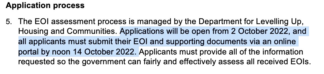
5/n Last observation for now: everything is being done in a huge hurry.

Local Authorities have *two weeks* to submit Expressions of Interest from today.

This is a recipe for botched proposals, minimal scrutiny and no impact assessments. #AttackOnNature gov.uk/government/pub…
6/n PS: Whilst National Parks, AONBs, Green Belts, SSSIs and World Heritage Sites are at least *mentioned* in the guidance doc, notable by their absence are any mention of Natura 2000 sites - SACs and SPAs: designations under the Habitats Regulations the govt wants to scrap...

• • •

Missing some Tweet in this thread? You can try to force a refresh
 

Keep Current with Guy Shrubsole

Guy Shrubsole Profile picture

Stay in touch and get notified when new unrolls are available from this author!

Read all threads

This Thread may be Removed Anytime!

PDF

Twitter may remove this content at anytime! Save it as PDF for later use!

Try unrolling a thread yourself!

how to unroll video
  1. Follow @ThreadReaderApp to mention us!

  2. From a Twitter thread mention us with a keyword "unroll"
@threadreaderapp unroll

Practice here first or read more on our help page!

More from @guyshrubsole

Sep 22
We only have a Right to Roam over 8% of England.

But today sees the publication of @CarolineLucas's new Bill to extend our Right to Roam! -publications.parliament.uk/pa/bills/cbill…

@Right_2Roam worked closely with Caroline to develop this Bill. Here's what it says 🧵 1/
The existing Countryside & Rights of Way Act (2000) gives the public a Right to Roam over mountains, moorland, heaths & downland.

Section 1 of @CarolineLucas's new Bill would extend that right to rivers, woods, & Green Belt land 2/n
S1 of the new Right to Roam Bill also seeks to resolve the problem of 'open access islands' - fragments of access land that you have to trespass to get to (see @PaulWhitewick's new video on this: ).

The Bill would redefine downland to try to fix this.
Read 7 tweets
Aug 2
In deepest darkest Devon, I’ve found what I think is a fragment of Atlantic hazelwood: a type of temperate rainforest & a very rare habitat, more usually found in western Scotland or Ireland. Let me tell you a bit about it… 🧵1/n
On Dartmoor’s eastern edge, north of Sampford Spiney, is a hidden valley. Here, veteran hazel trees grow like no other hazel you’ve seen: thick-boughed and gnarled, encrusted with mosses and lichens. Nothing like the coppiced hazels we're used to in hedgerows. 2/n
Epiphytes grow in profusion on these hazels, like the translucent polypody ferns, and String-of-sausages lichen (Usnea articulata), which festoons whole branches. 3/n
Read 12 tweets
Feb 3
Bracken is thought by some to be an indicator of former woodland.

New maps I've been passed reveal that bracken covers over 50,000 acres of Dartmoor & the Lake District.

Can we use bracken maps as a guide for regenerating temperate rainforest? 🧵1/n

lostrainforestsofbritain.org/2022/02/03/usi… Image
2/n Ecologist Ian Rotherham has pioneered the study of ‘ghost woods’ – places where trees have gone but other indicator species still grow: like wood sorrel, bluebells and bracken

Many old-growth temperate rainforests, like Black Tor Beare on Dartmoor, are surrounded by bracken: Image
3/n I’ve been sent new draft maps of bracken cover in two of England’s national parks – both of them within our ‘rainforest zone’.

I’ve found that Dartmoor has 14,370 acres of bracken (6% of the park) & the Lake District has at least 35,000 acres of bracken (also 6% of the park) ImageImage
Read 7 tweets
Jan 1
Good to see coastal erosion & sea level rise getting coverage, but also depressing how little the debate has moved on since I worked on it back in 2014.

There seems little appetite at a political or policy level to deal with this issue. Short thread 1/n
theguardian.com/environment/20…
2/n Back in 2013-14 the threat posed by climate change to our coasts got some coverage due to the Dec 2013 North Sea storm surge which came close to inundating Hull, & caused less some defended coastal settlements to succumb to eroding coastlines bbc.co.uk/news/uk-252530…
3/n At the time I worked for @friends_earth on flooding & climate change, and went to meet with various residents affected by accelerating coastal erosion, such as Malcolm Kerby in Happisburgh, on the east coast of Norfolk: opendemocracy.net/en/opendemocra…
Read 10 tweets
Nov 28, 2021
Today a group of us went for a trespass in King's Wood, a former ancient woodland cut down by the Dartington Estate in the 1930s for a conifer plantation. There’s no rights of way in it & no Right to Roam in private woods.

A thread about landowners, custodianship & trespass:
2/n King’s Wood nr Buckfastleigh was once an ancient woodland, dating back to 1600 or earlier. OS maps from the late 19th century show it as overwhelmingly deciduous. Today it’s classed as a Plantation on Ancient Woodland Site (PAWS).
3/n In the 1930s, the Dartington Estate, then owned by the Elmhirsts, acquired King’s Wood & ‘coniferised’ 300 acres of it in 10 years, according to this local history pamphlet. At the time, Dartington's woodland estate management had a big influence on modern forestry practices.
Read 8 tweets
Oct 10, 2021
Today a group of us went for a trespass in the Duke of Somerset’s woods at Berry Pomeroy near Totnes.

We found a vast pheasant shoot, the publicly inaccessible wood wrecked by forestry & weight of pheasant numbers, & dying pheasants - all propped up by public money. Thread 1/n
The Duke of Somerset owns the 2,800-acre Berry Pomeroy Estate in Devon. A small part of this land was recently sold for housing. The woods to the north have a permissive footpath through them, but the bulk are off-limits to the public – cos they’re a pheasant shoot. 2/n
The Duke’s woods are mostly former Ancient Woodland, cut down in the 20th century and replanted with a mix of conifers and deciduous trees.

There were plenty of fungi sprouting from the ancient forest floor, but even more pheasants. Like, hundreds of them. Everywhere. 3/n
Read 8 tweets

Did Thread Reader help you today?

Support us! We are indie developers!


This site is made by just two indie developers on a laptop doing marketing, support and development! Read more about the story.

Become a Premium Member ($3/month or $30/year) and get exclusive features!

Become Premium

Don't want to be a Premium member but still want to support us?

Make a small donation by buying us coffee ($5) or help with server cost ($10)

Donate via Paypal

Or Donate anonymously using crypto!

Ethereum

0xfe58350B80634f60Fa6Dc149a72b4DFbc17D341E copy

Bitcoin

3ATGMxNzCUFzxpMCHL5sWSt4DVtS8UqXpi copy

Thank you for your support!

Follow Us on Twitter!

:(