Alastair Thompson Profile picture
Oct 4 4 tweets 2 min read
#ExtremeWeather

I think we can now describe #HurricaneIAN's remnant storm centered roughly over NYC & 1000kms in diameter, as a "Gyre".

Gyre= "a broad area of slowly spinning air that rotates counterclockwise in the Nth Hemisphere."

Typically Gyres are not over land though.
Also as you can see here it is widening. Abd its eye is nearly complete.

Which raises the question: Is anarchy about to be loosed upon the world?
This is a very rapidly widening gyre - off the coast of Brazil, almost as big as the one over NYC, and one which may soon become a hurricane once it completes cyclone genesis.

It doesn't yet have a name, just a designation, but it will likely be called Julia or Karl.

• • •

Missing some Tweet in this thread? You can try to force a refresh
 

Keep Current with Alastair Thompson

Alastair Thompson Profile picture

Stay in touch and get notified when new unrolls are available from this author!

Read all threads

This Thread may be Removed Anytime!

PDF

Twitter may remove this content at anytime! Save it as PDF for later use!

Try unrolling a thread yourself!

how to unroll video
  1. Follow @ThreadReaderApp to mention us!

  2. From a Twitter thread mention us with a keyword "unroll"
@threadreaderapp unroll

Practice here first or read more on our help page!

More from @althecat

Oct 5
Meanwhile "diturbance" #Invest91L - which may soon become #HurricaneJulia - has taken on the appearance of a comet. Image
#Invest91L at sunset 5th October 2022
Read 4 tweets
Oct 5
#HurricaneIAN #ExtremeWeather Update THREAD

The remnants of Hurricane Ian are showing little sign of abandoning the Tri State area. This is from this morning CEST before sunrise.
And here we see #HurricaneIAN this evening. In the morning Ian had developed a distinct visible rotation at its center. And this evening this started to move south downthe coast rather than East as it has been forcasted to do for some time.
This is this morning's 24 hour forecast.
Read 11 tweets
Oct 5
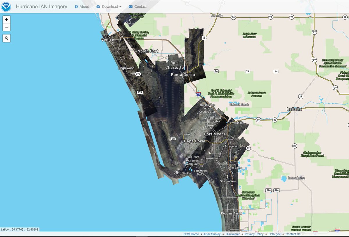
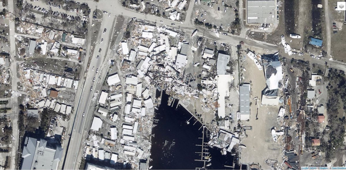
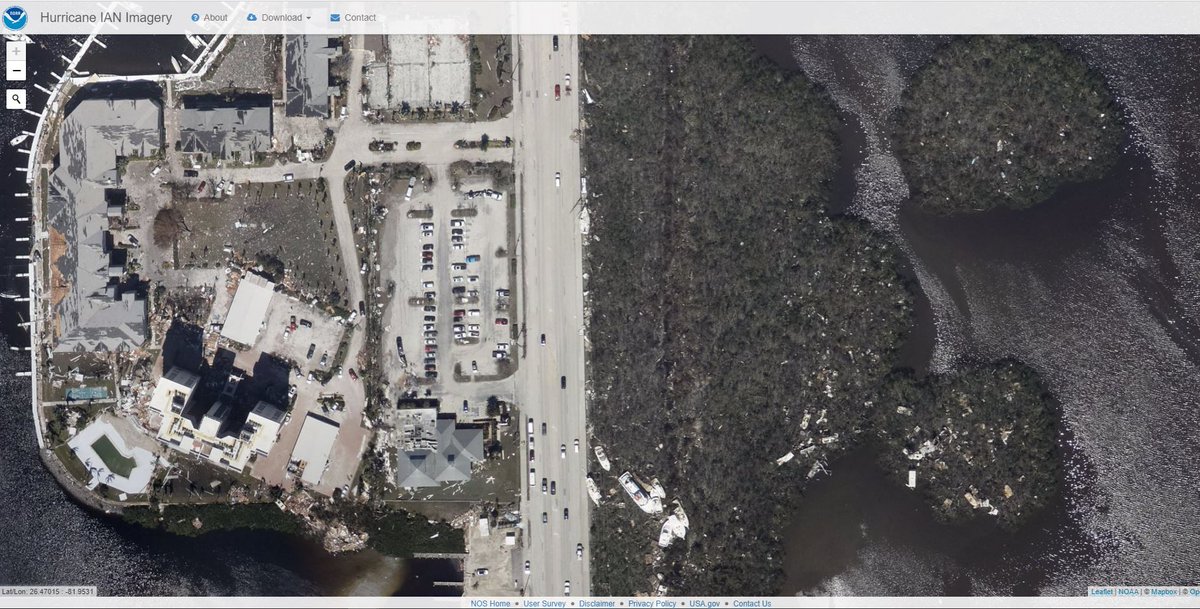
NOAA has published a remarkable tool to allow you to look at #HurricaneIAN damage in Florida and beyond.

This image shows the heart of the coverage of the satellite data - From Naples up to Venice. Imagery reveals how concentrated extreme damage is.
oceanservice.noaa.gov/news/sep22/ngs… Image
Fort Meyers Ground Zero ImageImageImageImage
More... ImageImageImageImage
Read 16 tweets
Oct 4
#ExtremeWeather Update

The NHC has updated its view on #Invest91L and now gives it a 60% chance of Tropical Storm formation in 2 days.

I'm wondering if it may already be a tropical storm as it has grown significantly in size in recent hours. ImageImage
The official NHC call is now 40% formation chance for #Invest91L in 48 hours 60% in 5 days. But I suspect that's still a significant over-estimation. ImageImageImageImage
This was early this morning before sunrise - long animation loop.
Read 7 tweets
Oct 4
#ClimateChangeNow #ExtremeWeatherUpdate THREAD

#Invest91L located East of the Seaward Islands has woken up at day break with explosive convection - and is starting to look organised.

This storm is forecast to move towards the Gulf of Mexico.
In the long range PWAT animation in the quoted thread above you can see one possible outcome, a massive cyclone embedded in a gyre which nearly covers the entire Gulf of Mexico.

But that is still a long way off and can probably be considered a worst case scenario.
Hurricane's are not predictable at such long ranges. But large scale dynamics about atmospheric water dynamics are fairly reliable at range.

At this point the NHC remains unconvinced by Invest91L itself. And gave it just a 20% probability of formation only this morning. ImageImage
Read 13 tweets
Oct 4
#ClimateChangeNow Update THREAD.

The unusual, unpredictable and #ExtremeWeather of #HurricaneIAN is still continuing in the North East of the US. The remnant low has strengthened and remains parked off the Maryland coast.

This storm has now spent nearly a week over the US.
Last night I posted a fairly discursive thread looking at the Tropical Atlantic, and some threats in the long range GFS forecast - including the threat posted by the remnants of #HurricaneIan
Here we are looking in particular at the stationary low pressure center off the coast of Maryland (Top Left) in the animation above. The impacts are becoming more significant now as the remnants of #IAN - back over the Atlantic are strengthening again.

Last 12 hours in DC.
Read 9 tweets

Did Thread Reader help you today?

Support us! We are indie developers!


This site is made by just two indie developers on a laptop doing marketing, support and development! Read more about the story.

Become a Premium Member ($3/month or $30/year) and get exclusive features!

Become Premium

Don't want to be a Premium member but still want to support us?

Make a small donation by buying us coffee ($5) or help with server cost ($10)

Donate via Paypal

Or Donate anonymously using crypto!

Ethereum

0xfe58350B80634f60Fa6Dc149a72b4DFbc17D341E copy

Bitcoin

3ATGMxNzCUFzxpMCHL5sWSt4DVtS8UqXpi copy

Thank you for your support!

Follow Us on Twitter!

:(