Alastair Thompson Profile picture
Oct 6 10 tweets 7 min read
#Carracas #Carribean #ExtremeWeather #WX #ClimateChangeNOW update Thread.

#Invest91L may not be a tropical storm yet, let alone a hurricane, and it may not even become one. But it is already having hurricane like rain impacts in Venezeula, and in particular in Carracas.
This morning there is a colossal 2.8 million km2 area of intense convection over the Nth South America/Amazon rain forest south of #Invest91L
Here is a view of the dominant convective system in all of this which has formed directly south of #Invest91L - and is shaped like a pine cone.
The scale of this is a bit mindblowing.
1. The full area of convective activity is 2.8 million km2 (a bit smaller than the size of India)
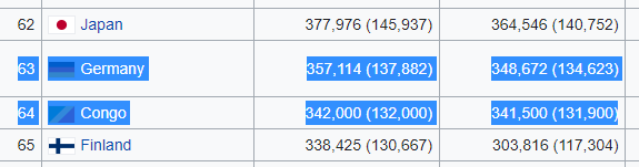
2. The area of the pinecone shaped storm complex currently over Venezeula producing very heavy rain is is 346,000 km2 the size of Germany.
In August there was some spectaular flooding in Caracas. See videos in these two tweets. What is happening now is likely a lot worse than this, and over a much much larger area.
1.
2.
This animation shows the rlationship between #Invest91L and this storm. Its south of the invest and ahead of it. The sun is just rising and as it gets hotter the convection is likely to increase.
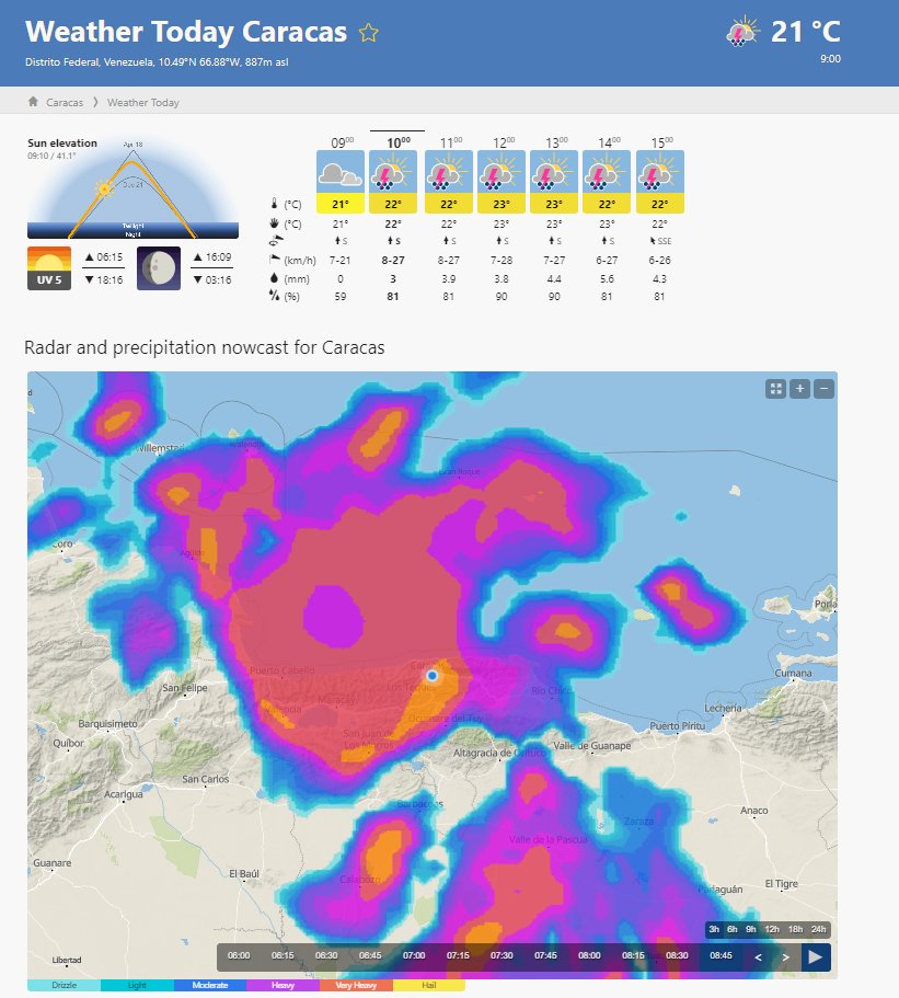
A @Meteoblue rain estimation for the full area. LINK >> meteoblue.com/en/weather/tod…
Here's perhaps a more realistic looking rain radar image for the area this morning. Still a lot of rain over Caracas
Meteoblue's forecasts show considerably less rain than the satellite and radar data suggest.
Here's another radar trace. From Accuweather.

• • •

Missing some Tweet in this thread? You can try to force a refresh
 

Keep Current with Alastair Thompson

Alastair Thompson Profile picture

Stay in touch and get notified when new unrolls are available from this author!

Read all threads

This Thread may be Removed Anytime!

PDF

Twitter may remove this content at anytime! Save it as PDF for later use!

Try unrolling a thread yourself!

how to unroll video
  1. Follow @ThreadReaderApp to mention us!

  2. From a Twitter thread mention us with a keyword "unroll"
@threadreaderapp unroll

Practice here first or read more on our help page!

More from @althecat

Oct 8
#ClimateChangeNOW #ExtremeWeather #HurricaneJulia update thread 8-10-22

A lot has changed in the last 12 hours - not so much in the short term but in the longer term model track predictions - and therefore in the outcomes which can be expected for the wider region.
Specifically fromthe latest GFS run (and its predecessors) the degree of uncertainty with respect to impacts is increasing. At present Julia is not officially a hurricane and the extent of structure in the 300km wide central area of convection is not known.

Latest GFS Run.
The GFS data has changed the official forecast in line with what we see inthe last model and instead of taking a more northerly path through central America the storm is now expected to cross the Isthmus into the Pacific relatively swiftly. Image
Read 23 tweets
Oct 7
I get that the TPLF do not want to attend peace AU talks, ever, anywhere.

But I am amazed at the lengths they seem to be prepared to go to in order make sure they do not discuss peace so they can continue a completely pointless war that is killing 1000s of their children. Image
Enlisting the @WHO, @JosepBorrellF, a majority of the European Parliament and the UNHRC and the former President of Kenya in this project is a master work, especially whilst keeping them all in the dark about the master plan.
But to what end?

Do the TPLF love war so much that they seek to never stop? Even if it means living in caves and hiding from drones and seeing their families and friends die?

It really is a tragedy. The peace talks ought to be on tomorrow in South Africa.
Read 6 tweets
Oct 7
This is a controversial text. Trans:

"We transgressed against people belittling them.
Their fates our fate, please walk in their shoes.

I think tplf is thinking of the London negotiations and saying this to Azmari. As they left them there, they will be left there."
I gather the reference to London negotiations is to those held in 1991 following the fall of Mengistu.
Who or what is Azmari?
Read 4 tweets
Oct 7
This might be a good moment for @WilliamsRuto to replace his peace envoy with someone less closely associated with the TPLF.
The irony of this is that the communique that he refers to is dated the same day as the invitation to the talks was sent - which the TPLF took four days to officially respond to. This is not the more recent statement issued publicly by @reda_getachew.
It is abundantly clear that former President Uhuru Kenyatta is doing the bidding here of the TPLF. And I would not be at all surprised if @DrTedros is involved in this someway also.
Read 9 tweets
Oct 7
Future #HurricaneJulia #ExtremeWeather update thread.

Tropical Depression #13L is finally over open water. At 355,000km2 it is a bit bigger than Germany. And it is expected to become a hurricane before arriving in Nicaragua on Sunday. It has already killed at least 8 people. Image
Here is an HRWF model simulation of the storm's path to Nicaragua it is currently expected to arrive there at around 3am local time, but wind and rain will arrive a lot earlier.
Earlier I posted a thread looking a little closer at the expected impact/threadt posed to the 56 million inhabitants of 8 Central American Countries (excluding Mexico) over the next 16 days.
Read 5 tweets
Oct 7
#CentralAmerica #ClimateChangeNOW #ExtremeWeather #HurricaneJulia #IMPACT 16-day assessment THREAD.

It is time to consider what is about to happen in Central America from a #LossAndDamages perspective. Image
With less than 72 hours till #HurricaneJulia's expected landfall in Nicaragua, #TD13L #PC13L #Invest91L has already wreaked untold havoc in Venezeula, it is now over Colombia. The death toll is rising.

What is ahead is dangerous. #ExtremeWeather impacts for 200 million souls. ImageImage
Localised extreme events (locations unknown) are modelled in this forecast of up to 40 inches of rain over the 16 day period. And on the current forecast the storm will make two passes, turning back after reaching the Gulf of Mexico.
Read 25 tweets

Did Thread Reader help you today?

Support us! We are indie developers!


This site is made by just two indie developers on a laptop doing marketing, support and development! Read more about the story.

Become a Premium Member ($3/month or $30/year) and get exclusive features!

Become Premium

Don't want to be a Premium member but still want to support us?

Make a small donation by buying us coffee ($5) or help with server cost ($10)

Donate via Paypal

Or Donate anonymously using crypto!

Ethereum

0xfe58350B80634f60Fa6Dc149a72b4DFbc17D341E copy

Bitcoin

3ATGMxNzCUFzxpMCHL5sWSt4DVtS8UqXpi copy

Thank you for your support!

Follow Us on Twitter!

:(