#CentralAmerica #ClimateChangeNOW #ExtremeWeather #HurricaneJulia #IMPACT 16-day assessment THREAD.
It is time to consider what is about to happen in Central America from a #LossAndDamages perspective.
It is time to consider what is about to happen in Central America from a #LossAndDamages perspective.

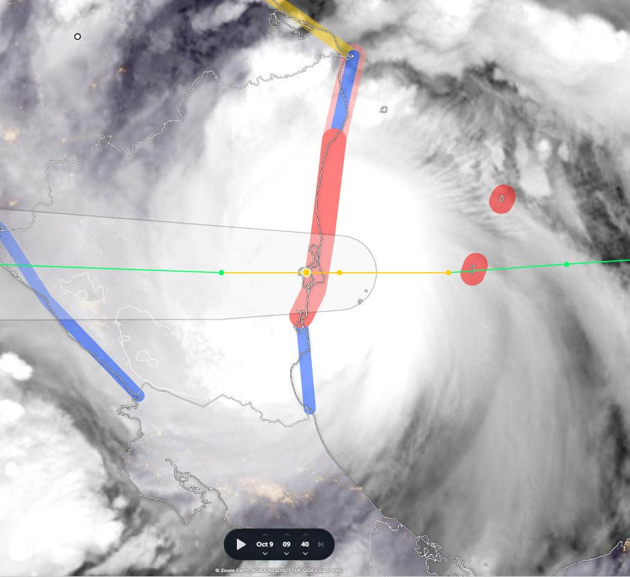
With less than 72 hours till #HurricaneJulia's expected landfall in Nicaragua, #TD13L #PC13L #Invest91L has already wreaked untold havoc in Venezeula, it is now over Colombia. The death toll is rising.
What is ahead is dangerous. #ExtremeWeather impacts for 200 million souls.
What is ahead is dangerous. #ExtremeWeather impacts for 200 million souls.


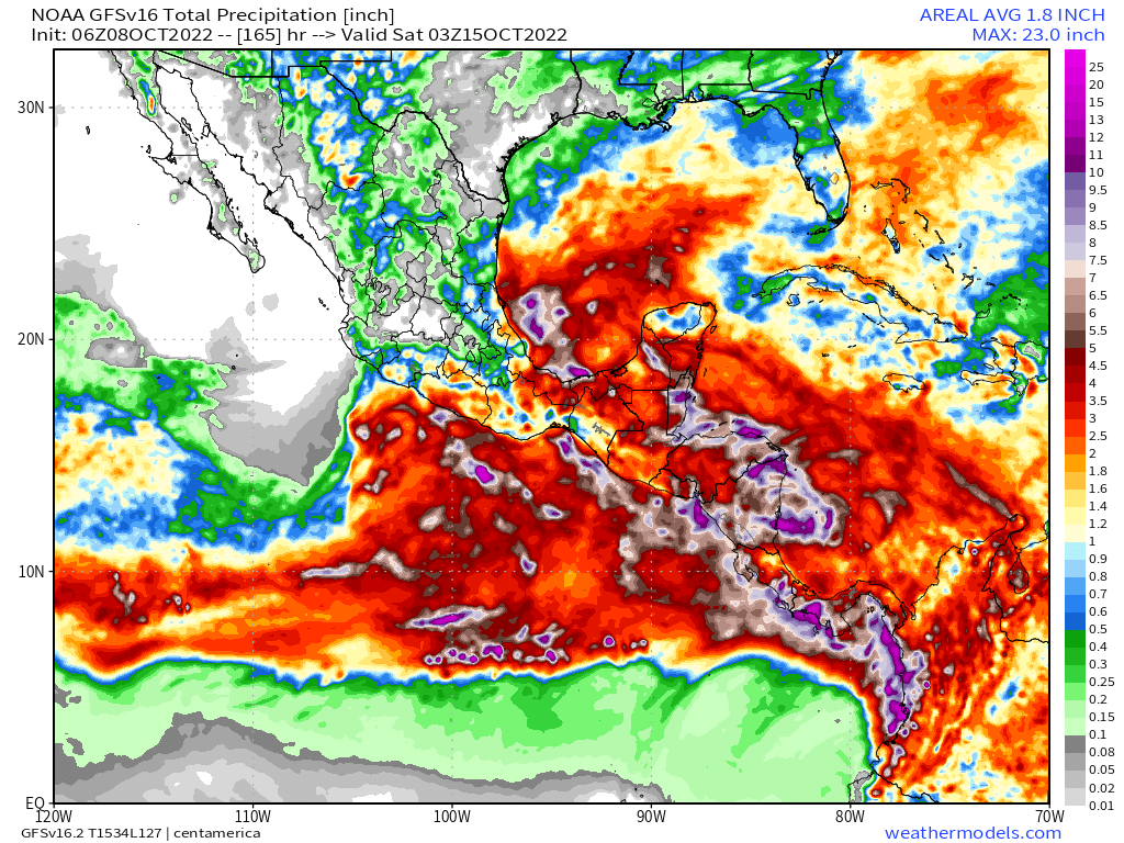
All of these countries are forecast to recieve extreme rainfall on coastal areas (where people are concentrated) and in many cases deep inland.
The purple and white fringed areas in the map (Top Right) are forecast to recieve 7-25 inches of rain.
The purple and white fringed areas in the map (Top Right) are forecast to recieve 7-25 inches of rain.

Localised extreme events (locations unknown) are modelled in this forecast of up to 40 inches of rain over the 16 day period. And on the current forecast the storm will make two passes, turning back after reaching the Gulf of Mexico.
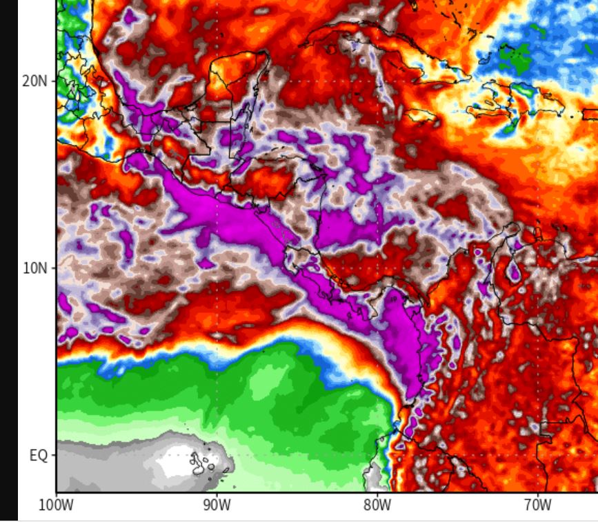
This PWAT view (atmospheric water vapour) shows what is expected to happen. In the next few hours the storm is expected to grow to straddle the Central American isthmus and start gathering water from the Eastern Pacific into its core.
Whilst the hurricane may technically decay by the time its leading edge reaches Mexico in 4-5 days, it will by then be a colossal storm - one which will then be pushed back south east towards South America by an arctic blast which is already coming south over North America.


Whilst this is great news for Mexico, Texas and Florida, it is disastrous for Central America and will likely make a catastrophic situation calamatous, especially in low lying coastal areas in Central America - home to 184 million people.


There are 56 million outside of Mexico, which at present will be comparatively speaking less effected from the countries to its south east. But due to the inherent uncertainty of hurricane behaviour beyond 3 days, out comes for Mexico could be worse than forecast.
Ok. So how much preparation has there been for this storm which has been in the forecast models for the last 16 days. Has the US/UN started deploying assistance? Have they even mentioned it?
Short answer is no from what I can see via google news.
Short answer is no from what I can see via google news.


Global media - outside specialised weather channels - has also largely missed this approaching disaster.
Understandably weather reporting tends to be a domain of weather bulletins, and then focussed on the specific audiences.
Understandably weather reporting tends to be a domain of weather bulletins, and then focussed on the specific audiences.

The absence of preparedness is - partly - understandable as officially the "storm" - which is probably around 60 hours from arriving in Nicaragua - hasn't been officially designated a hurricane.
Officially it is still Tropical Depression 13
nhc.noaa.gov/?atlc#Thirteen
Officially it is still Tropical Depression 13
nhc.noaa.gov/?atlc#Thirteen

Systems which fail to provide timely offical alerts to #ExtremeWeather threats such as this need to be fixed.
The danger of this storm risk has been obvious in the weather models & monitored by NHC and a matter of discussion since Oct. 3.
The danger of this storm risk has been obvious in the weather models & monitored by NHC and a matter of discussion since Oct. 3.
https://twitter.com/althecat/status/1577028539685404672?s=20&t=0lI9IxlpUOa2xpJM-z78MA

The sheer scale of this event is such the threat it posed must have been obvious earlier, and a review to establish when the signals were clear enough to have risen to some kind of alert status ought to be undertaken.


As it stands however, @reliefweb - the humanitarian operations portal has no threat assessments on any of the 8 closely affected country pages even now - with the impacts already beginning.


So what needs to be done?
It is obvious what the problem here is. There is no agency tasked with global weather threat assessment. JTWC and NHC do a great job in the narrow area of cyclone threats - but as the events in Pakistan and now here show - cyclones have changed.
It is obvious what the problem here is. There is no agency tasked with global weather threat assessment. JTWC and NHC do a great job in the narrow area of cyclone threats - but as the events in Pakistan and now here show - cyclones have changed.
Three recent examples:
1. What happened in Pakistan was not a cyclone. Though it looked a lot like one.
1. What happened in Pakistan was not a cyclone. Though it looked a lot like one.
https://twitter.com/althecat/status/1563479903252582405?s=20&t=Z_v87lK1EKASM_qVkVmQDw
The intensity of a given cyclone is not that relevant in relation to Impact. #INFA (2021 July China) was only a CAT 2 storm, but it was huge, and like #HurricaneIAN and Pakistan, the storm remained intact over land.
https://twitter.com/althecat/status/1420487111094976512?s=20&t=Z_v87lK1EKASM_qVkVmQDw

3. These new massive hurricane's (like #IAN) are also intrinsically harder to model & forecast - because they are bigger and harder to compute.
And this is a serious issue in relation to the "hurricane/disturbance" threat right now Central America .
And this is a serious issue in relation to the "hurricane/disturbance" threat right now Central America .
There was not a lot of advance discussion of what is expected to become #HurricaneJulia because it was difficult to determine whether it met "designation criteria" = resource allocation.
As of now, the scale of damage in Venezeula from this "tropical wave" remains unknown.
As of now, the scale of damage in Venezeula from this "tropical wave" remains unknown.
But the data warning of the outcome which is about to unfold in Central America was available in the system - it just wasn't identified early enough to do something about it because of the way meteorology is practiced.
Weather forecasting output is generally short range, commercial and localised. Nobody is tasked with the bigger picture - though the @Twitter WX community does do this informally.
@Twitter For obvious reasons and informal social media based approach to weather hazards is not able to deploy the resources, and or make the necessary decisions for disaster preparedness which are required - though it is very helpful.
In the case of the US and #HurricaneIAN FEMA is tasked with the responsibility to anticipate and prepare for weather disasters.
Something like this is now needed globally.
Something like this is now needed globally.
In the relief web pages I shared screenshots of earlier there are lots of mentions of disaster/flooding preparedness efforts. But for an incident of this scale it is likely that international assistance will be needed - just as it was last year in Madagascar and Mozambique.
UNSG @AntonioGurerres has pointed to the need for this issue to be addressed at the upcoming #COP27 in Egypt in a comprehensive manner. What we are about to see unfold in Central America will likely provide more impetus to this imperative.
/ends
@threadreaderapp unroll
@threadreaderapp unroll
• • •
Missing some Tweet in this thread? You can try to
force a refresh