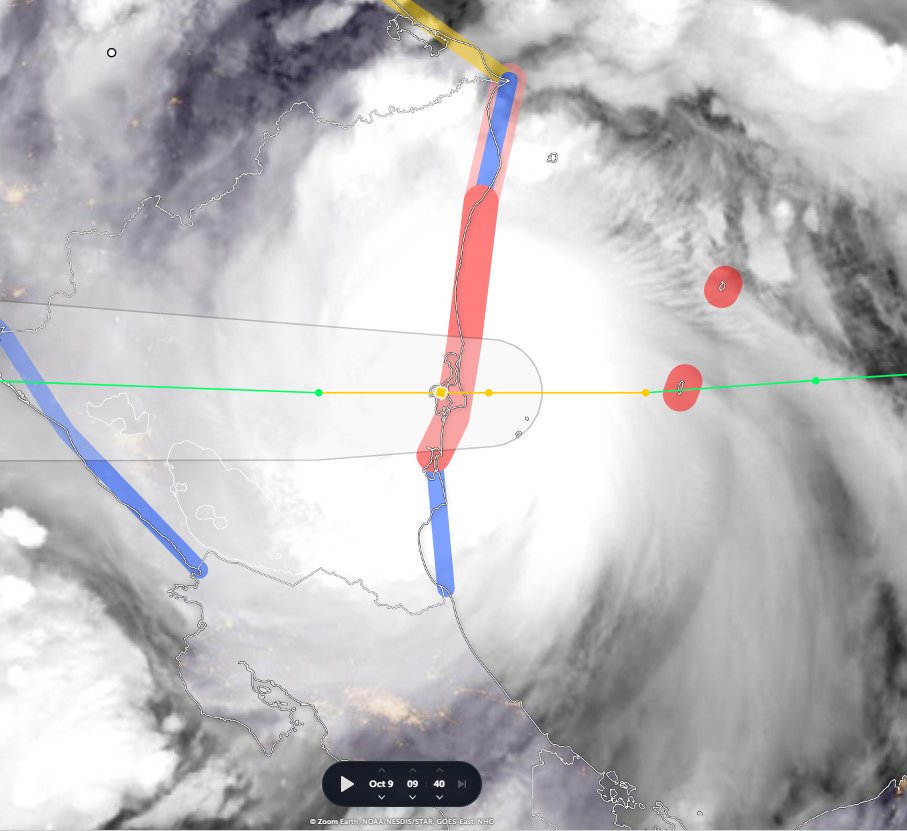
Tropical Depression #13L is finally over open water. At 355,000km2 it is a bit bigger than Germany. And it is expected to become a hurricane before arriving in Nicaragua on Sunday. It has already killed at least 8 people.
Here is an HRWF model simulation of the storm's path to Nicaragua it is currently expected to arrive there at around 3am local time, but wind and rain will arrive a lot earlier.
Earlier I posted a thread looking a little closer at the expected impact/threadt posed to the 56 million inhabitants of 8 Central American Countries (excluding Mexico) over the next 16 days.
TL/DR version: The warnings for, and preparations for what is about to unfold in Central America is inadequate and poorly understood. Lessons will need to be learned by the international community from what is about to unfold.
This is the latest GFS model run 07/06Z for the storm it runs for 16 days, and it appears the model expectations for storm intensity have increased based on the increased impacts in the Gulf of Mexico now indicated - and includes another hurricane strike on Cuba.
• • •
Missing some Tweet in this thread? You can try to
force a refresh
Cat 1 #HurricaneJulia is now making landfall over Nicaragua, its core covers 3/4 of the Eastern Seaboard and will extreme rainfall is underway over more than 50% of the country already. The scale of the storm is comparable to #HurricaneIAN was at Cat 5 on approach to Florida.
#HurricaneJulia's IR presentation on landfall. The colour gradation represents cloud top temperature with yellow representing the coldest and highest parts of the cyclones structure.
Here is the current HRWF hurricane model foreast for Monday evening. A "Wind Gap Event" associated with the narrow isthmus between the Gulf of Mexico and the Pacific Ocean in southern Mexico is currently forecast to dissipate the storm shortly after this moment.
The latest article from @declanwalsh is a curious affair. His sources are un-named "Western and Tigrayan" officials and Cameron Hudson (whose affiliation had to be correctd after publication).
The result is a garbled TPLF interpretation of recent events. nytimes.com/2022/10/08/wor…
It looks like a rushed job at the request of a @nytimes foreign desk editor who is even less familiar with the facts of the conflict than Declan Walsh appears to be. Declan's last story on the war was about the questionable kindergarten attack on 26th Aug. nytimes.com/2022/08/26/wor…
For a publication of the statureof the @nytimes - perhaps undeserved now - to publish just two stories in nearly two months about the largest, and 2nd most politically sensitive and controversial war on the planet is journalistic malpractice.
#TSJulia's wind and convection area now covers 2.4 million km, draging moisture off the Pacific Ocean over Panama & Costa Rica. Her outer rain bands extend from Colombia to Honduras - and she is not yet a hurricane.
While #TSJulia or #HurricaneJulia is not expected to last much longer, the #ExtremeWeather event associated with the storm is forecast to bring extreme/catastrophic weather across the entire region over the coming fortnight.
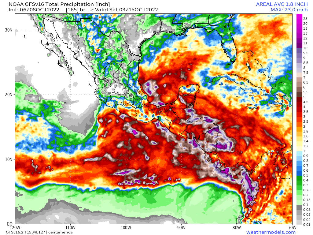
Accumulating rainfall forecast - 16 days. GFS Model
Exactly what will happen is far from clear as the forecasts keep changing but the combination of very high atmospheric water, and a massive arctic blast coming south (even pushing a small hurricane backwards down Mexico's Pacific Coast as you see here is not good.
A quick update on the wider #HurricaneJulia long term rainfall prognosis for Central America. Which unfortunately is deteriorating significantly in the latest runs.
The first week (Hurricane Julia) is bad, but the rains continue for another full week till the end of the forecast period. The next few tweets show how the model picture has evolved.
The full runs are not yet available but we have the first 120 hours - till 13th Oct.
Here's the IWVT (Atmospheric Water Transport/Energy) view - which shows #TSJulia crossing into the Pacific and taking a portion of the saturated atmosphere with her north west up the coast.
#ClimateChangeNOW#ExtremeWeather#HurricaneJulia update thread 8-10-22 (late evening CEST)
The possibility Julia may never become a hurricane is clearly on the cards. Her continued divergence (southwards) from the offical track also has signifcant implications r.e. impact.
This is illustrated in the latest GFS model run. The full 16 day run is a little implausible but this 165 hours is at least credible.
As you can see here the remnants of Julia cross the isthmus (as discussed in the last update) and then moves deeper into the Pacific.
The first image here is the rain solution for that first 165 hours.
The second is a rainfall solution through to 300 hours. Whilst still alarming to say the least, it is different from earlier runs wrt more rain over the southern coasts than the northern coasts.
A lot has changed in the last 12 hours - not so much in the short term but in the longer term model track predictions - and therefore in the outcomes which can be expected for the wider region.
Specifically fromthe latest GFS run (and its predecessors) the degree of uncertainty with respect to impacts is increasing. At present Julia is not officially a hurricane and the extent of structure in the 300km wide central area of convection is not known.
Latest GFS Run.
The GFS data has changed the official forecast in line with what we see inthe last model and instead of taking a more northerly path through central America the storm is now expected to cross the Isthmus into the Pacific relatively swiftly.