#ClimateChangeNOW #ExtremeWeather #HurricaneJulia update thread 8-10-22
A lot has changed in the last 12 hours - not so much in the short term but in the longer term model track predictions - and therefore in the outcomes which can be expected for the wider region.
A lot has changed in the last 12 hours - not so much in the short term but in the longer term model track predictions - and therefore in the outcomes which can be expected for the wider region.
https://twitter.com/althecat/status/1578139600220033028
Specifically fromthe latest GFS run (and its predecessors) the degree of uncertainty with respect to impacts is increasing. At present Julia is not officially a hurricane and the extent of structure in the 300km wide central area of convection is not known.
Latest GFS Run.
Latest GFS Run.
The GFS data has changed the official forecast in line with what we see inthe last model and instead of taking a more northerly path through central America the storm is now expected to cross the Isthmus into the Pacific relatively swiftly. 

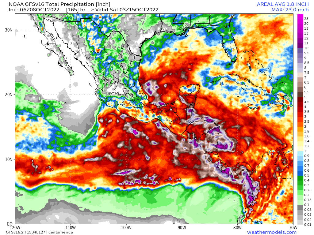
And this changes everything. The storm appears to still be expected to lose its hurricane status quickly over Nicaragua, but because it will likely be almost half over water - its ability to produce rain is increased not diminished. This is the corresponding model rain forecast.
Here are the two 16-day total rain forecasts for comparison.
Right: Yesterday
Left: This morning
The new version is a lot worse - but neither is necessarily right, as a great deal depends on how strong Julia gets over the nex 48 hours before it reaches Nicaragua.
Right: Yesterday
Left: This morning
The new version is a lot worse - but neither is necessarily right, as a great deal depends on how strong Julia gets over the nex 48 hours before it reaches Nicaragua.


The next part of this thread will look at the last four model predictions for atmospheric water levels - as that is the underlying cause of this #ExtremeWeather event - high levels of water makes atmosphere unstable, leading to convective storms, increasing the amount of water.
Notably in all four of the latest GFS runs there is an indication that a storm of some kind may form in the Gulf of Mexico. The good news is that storm will probably not be Julia itself - but rather a storm which forms in parts of its output.
RUN 1: 07/06 GFS RUN - IWVT
RUN 1: 07/06 GFS RUN - IWVT
[IVWT = Integrated Water Vapour Transport measured in kg/m/s = which is really a measure of energy - the kinetic energy of a movement of mass]
In this first 07-06 run #HurricaneJulia remains on a northerly pass (which is no longer indicated) a 2nd storm spins up to the south.
In this first 07-06 run #HurricaneJulia remains on a northerly pass (which is no longer indicated) a 2nd storm spins up to the south.
RUN 2: 07/12 GFS RUN - IWVT
6 hours later this run is similar but shows the storms in the west becoming tropical storms - albeit in their infancy. Importantly including one which is in the Gulf.
The media consensus that this event will not affect mainland US no longer holds.
6 hours later this run is similar but shows the storms in the west becoming tropical storms - albeit in their infancy. Importantly including one which is in the Gulf.
The media consensus that this event will not affect mainland US no longer holds.
RUN 3: 07/18 GFS RUN - IWVT
Here we see the Hurricane Julia take a more southerly path - to the Pacific coast - disapate, form another storm and eventually arrive in the Gulf. [NOTE: all of these forecasts so far are for 144 hours - which you can see in the time stamps].
Here we see the Hurricane Julia take a more southerly path - to the Pacific coast - disapate, form another storm and eventually arrive in the Gulf. [NOTE: all of these forecasts so far are for 144 hours - which you can see in the time stamps].
This is a comparatively benign forecast. However it is not the end. The trend in change is pointing towards #HurricaneJulia making it out over the Pacific - which is not the case in this model run.
RUN 4: 07/12 GFS RUN - IWVT
This is similar to the previous run - and it is the run which produced the substantially increased rainfall forecast - particularly for Guatemala - and which will also bring significant rains significantly further into Mexico.
This is similar to the previous run - and it is the run which produced the substantially increased rainfall forecast - particularly for Guatemala - and which will also bring significant rains significantly further into Mexico.
The overall trend here remains similar and is moving in a direction which suggests worse impacts in CA than we were expecting yesterday - which were already dire (See thread below). This progression may be due to an increase in total water vapour mass.
https://twitter.com/althecat/status/1578394231974117376?s=20&t=_8zq4rCV9VhvihC12o1v8A
Ok. If anyone is following this they may now realise where it is going. And the latest fresh run confirms this hypothesis - the further the path of #HurricaneJulia trends to the south, the more water it will carry across the isthmus into the Pacific.
In this forecast a hurricane then forms over the East Pacific cyclone genesis hot spot, hoovers up a lot of that water and takes it west.
But the remnants of #HurricaneJulia make it back into the Gulf of Mexico on Oct 15th - which could well begin the next phase of this story.
But the remnants of #HurricaneJulia make it back into the Gulf of Mexico on Oct 15th - which could well begin the next phase of this story.
An alternative (hypothetical) and even better scenario is now apparent however. And that is that #HurricaneJulia makes it far enough into the Pacific that she can take all of this moisture with her out into the Pacific.
This is possible if she strengthens more than expected.
This is possible if she strengthens more than expected.
A lot is resting on what happens in the next few hours during which #HurricaneJulia is expected to go through her strengthening phase. Interestingly, this latest HRWF model hurricane simulation suggests she may not reach hurricane status at all.
Unfortunately, if correct this (I think) makes the possibility of a successful complete transit of the Central America isthmus less likely
[Readers note] I will revisit the long-range model forecasts once we know the outcome of the central question here - namely how much will #TropicalStormJulia intensify?
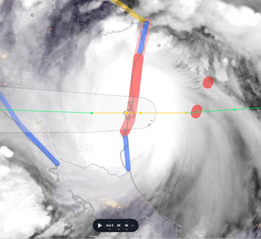
Satellite imagery definitely shows a strengthening storm - the central eye has expanded significantly. It also indicates that the trajectory of the storm is towards the southern bounds of the forecast track.

(continuing story)
/ENDS
@Threadreaderapp unroll
/ENDS
@Threadreaderapp unroll
P.S. looking a bit closer at this trajectory issue. [Trajectory and Intensity are closely related]
This image is an attempt at extrapolating the current variation from the official @NHC_Atlantic track.
If this is the outcome we are back to the drawing board.
This image is an attempt at extrapolating the current variation from the official @NHC_Atlantic track.
If this is the outcome we are back to the drawing board.

This would likely lead to strengthening of the storm over the Pacific. What happens after that I do not know. But it could result in the storm heading further into the Pacific and taking its atmospheric water with it.
Which would be good.
(P.S ends)
Which would be good.
(P.S ends)
/ends
@Threadreaderapp unroll
@Threadreaderapp unroll
• • •
Missing some Tweet in this thread? You can try to
force a refresh