#ClimateChangeNOW #ExtremeWeather #HurricaneJulia update thread 8-10-22 (late evening CEST)
The possibility Julia may never become a hurricane is clearly on the cards. Her continued divergence (southwards) from the offical track also has signifcant implications r.e. impact.
The possibility Julia may never become a hurricane is clearly on the cards. Her continued divergence (southwards) from the offical track also has signifcant implications r.e. impact.
https://twitter.com/althecat/status/1578691456445054976
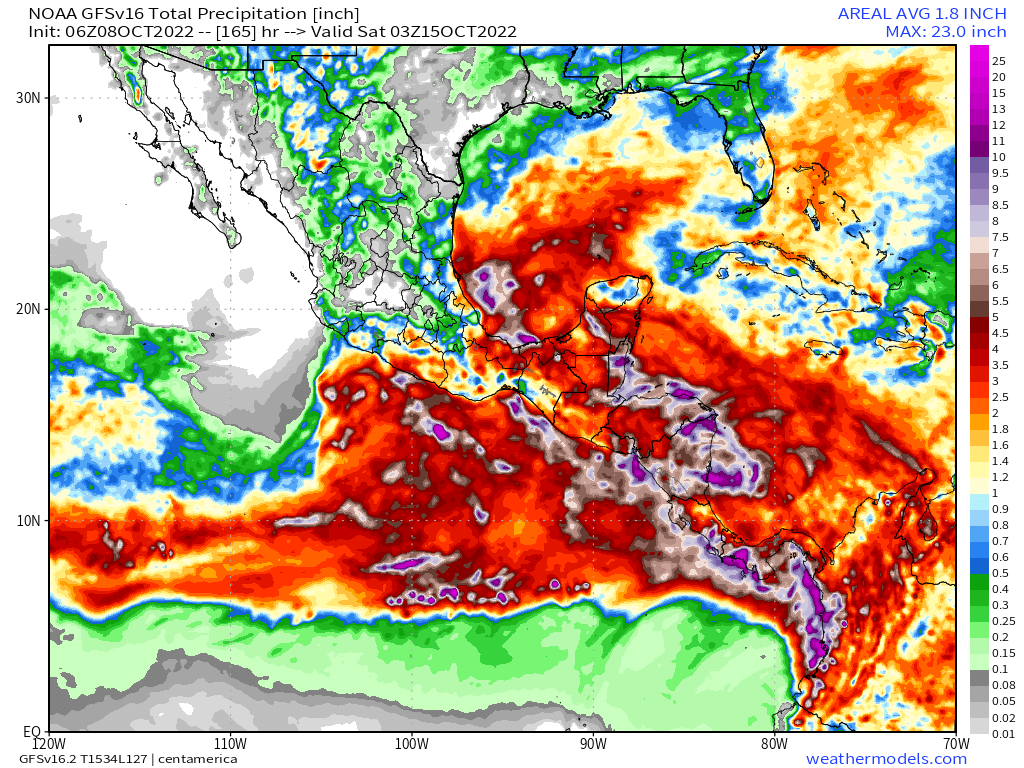
This is illustrated in the latest GFS model run. The full 16 day run is a little implausible but this 165 hours is at least credible.
As you can see here the remnants of Julia cross the isthmus (as discussed in the last update) and then moves deeper into the Pacific.
As you can see here the remnants of Julia cross the isthmus (as discussed in the last update) and then moves deeper into the Pacific.
The first image here is the rain solution for that first 165 hours.
The second is a rainfall solution through to 300 hours. Whilst still alarming to say the least, it is different from earlier runs wrt more rain over the southern coasts than the northern coasts.

The second is a rainfall solution through to 300 hours. Whilst still alarming to say the least, it is different from earlier runs wrt more rain over the southern coasts than the northern coasts.


Here is a portion of the latest NHC advisory that mentions this more southerly trajectory and its impact. However as of right now the storm appears to be continuing to diverge to the south of the track forecast, potentially amplifying this change over the next 72 hours. 

Here is the latest GFS PWAT (Water Vapour) forecast from the same model - again over the next 165 hours till Oct 15th. The change trend is continuing to bring more water into the gulf. But the arctic air blast which is defending the US has the upper hand in this run.
This is the full 16 day IWVT (integrated Water Vapour Transport) plot from the same run. And I have some issues with it, specifically the three small hurricanes it is predicting. This seems implausible to me intuitively.
Also the hurricane (TR at the end) heading SW is odd.
Also the hurricane (TR at the end) heading SW is odd.
The following 12-08Z GFS run has a more credible outcome - a single hurricane forming over the Pacific, meandering about for a few days and then heading out into the Pacific.
Tropical Storms/Cyclones rarely travel northwards over the isthmus.
Tropical Storms/Cyclones rarely travel northwards over the isthmus.
This is the rainfall solution at 354 hours for the 12-08Z model it is a small improvement on the 6-08Z model in terms of impact with the main difference being more rain concentrations on the Pacific coast. 

However a more southerly path across Nicaragua of #TSJulia rather than #HurricaneJulia (and there are increasing signs this is possible) would significantly improve the situation for the Central American countries in Julia's path.
To be clear though, this remains an extremely hazardous storm and the impacts across all Central American states - increasingly including southern Mexico are still likely to be very severe - particularly from flooding and mudslides.
The other aspect of changes in the model outcomes is relevant to possible threats to the US, which remain low thanks to a series of arctic blasts of dry air which are effectively protecting the southern coast.
Some recent runs had indicated the gulf threat might be increasing.
Some recent runs had indicated the gulf threat might be increasing.
But not any more. In the latest GFS run this dry air mass, which is now forecast to be cover nearly all the United States seems to be increasing.
Interestingly this air coming in from the north is also very warm and appears to originate in the far North Pacific.
This is a 16 day temperature anomaly graph. The arctic Alaska and Canada are much warmer than normal.
This is a 16 day temperature anomaly graph. The arctic Alaska and Canada are much warmer than normal.
Here we see the origins of this hot air south west of Alaska. This animation from 5th Oct. shows atmospheric height anomaly - which is indicative of high pressure areas (usually clear from cloud - and therefore likely to get hot).
This anumation picks up the story three days later.
The hot air continues to travel east, and it appears to be the explanation for why the (highly speculative) hurricane - we can see at the end of the modeling window - is heading South West towards Florida.
In this view of Atlantic temperature anomaly you can see the hurricane at the end.
/ends
@threadreaderapp unroll
@threadreaderapp unroll
• • •
Missing some Tweet in this thread? You can try to
force a refresh


