Alastair Thompson Profile picture
Oct 8 5 tweets 4 min read
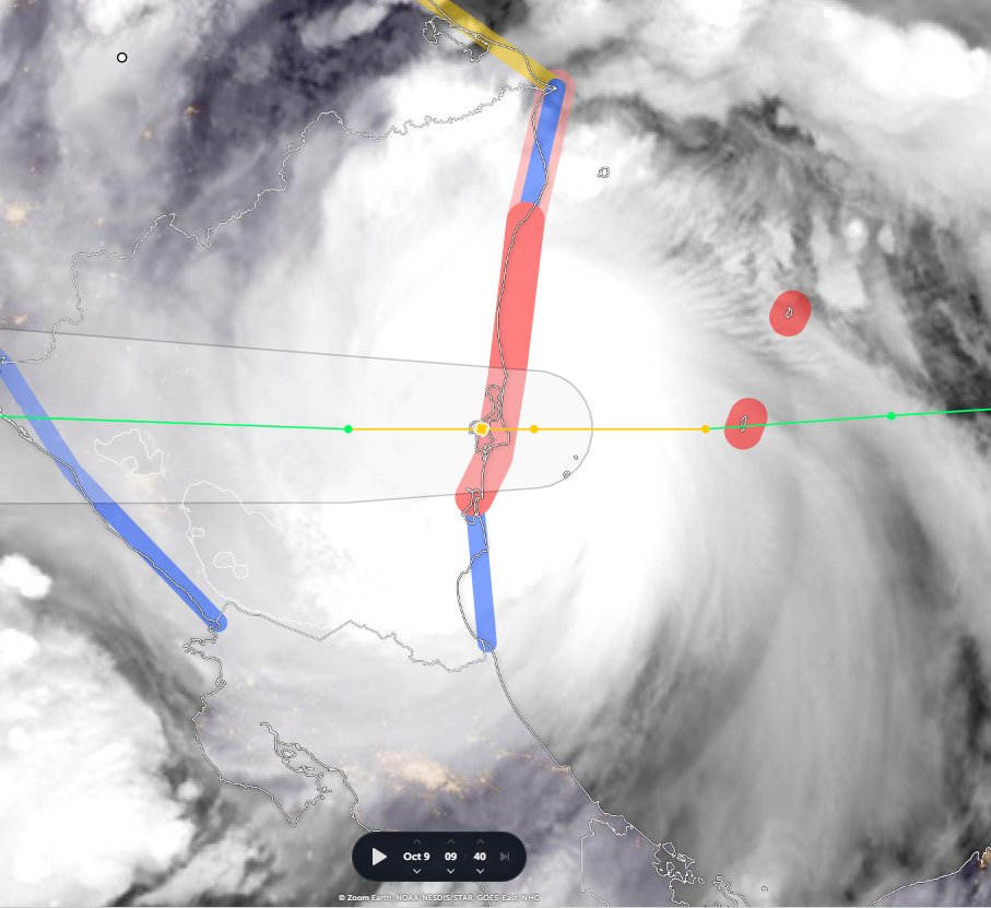
#HurricaneJulia #TSJulia #CentralAmerica #ExtremeWeather.

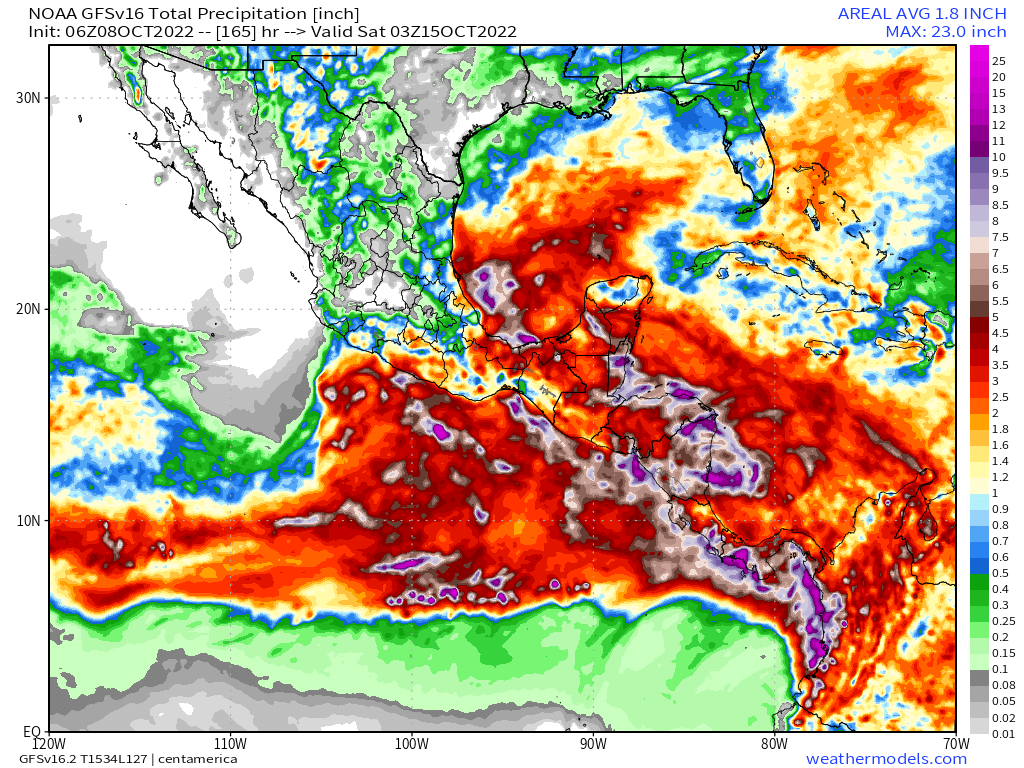
A quick update on the wider #HurricaneJulia long term rainfall prognosis for Central America. Which unfortunately is deteriorating significantly in the latest runs.

Left: 180 Hours
Right:384 Hours
The first week (Hurricane Julia) is bad, but the rains continue for another full week till the end of the forecast period. The next few tweets show how the model picture has evolved.
The full runs are not yet available but we have the first 120 hours - till 13th Oct.

Here's the IWVT (Atmospheric Water Transport/Energy) view - which shows #TSJulia crossing into the Pacific and taking a portion of the saturated atmosphere with her north west up the coast.
However much of the moisture flow (and Julia's outflows) remain airborne flowing into the Gulf of Mexico where it collides with the arctic blast and is carried east over North Florida, Georgia and into the Carolinas.
It seems that #TSJulia will have impacts in the US - just not as a cyclone.

• • •

Missing some Tweet in this thread? You can try to force a refresh
 

Keep Current with Alastair Thompson

Alastair Thompson Profile picture

Stay in touch and get notified when new unrolls are available from this author!

Read all threads

This Thread may be Removed Anytime!

PDF

Twitter may remove this content at anytime! Save it as PDF for later use!

Try unrolling a thread yourself!

how to unroll video
  1. Follow @ThreadReaderApp to mention us!

  2. From a Twitter thread mention us with a keyword "unroll"
@threadreaderapp unroll

Practice here first or read more on our help page!

More from @althecat

Oct 9
Cat 1 #HurricaneJulia is now making landfall over Nicaragua, its core covers 3/4 of the Eastern Seaboard and will extreme rainfall is underway over more than 50% of the country already. The scale of the storm is comparable to #HurricaneIAN was at Cat 5 on approach to Florida. ImageImageImageImage
#HurricaneJulia's IR presentation on landfall. The colour gradation represents cloud top temperature with yellow representing the coldest and highest parts of the cyclones structure.
Here is the current HRWF hurricane model foreast for Monday evening. A "Wind Gap Event" associated with the narrow isthmus between the Gulf of Mexico and the Pacific Ocean in southern Mexico is currently forecast to dissipate the storm shortly after this moment. Image
Read 11 tweets
Oct 9
The latest article from @declanwalsh is a curious affair. His sources are un-named "Western and Tigrayan" officials and Cameron Hudson (whose affiliation had to be correctd after publication).
The result is a garbled TPLF interpretation of recent events. nytimes.com/2022/10/08/wor…
It looks like a rushed job at the request of a @nytimes foreign desk editor who is even less familiar with the facts of the conflict than Declan Walsh appears to be. Declan's last story on the war was about the questionable kindergarten attack on 26th Aug. nytimes.com/2022/08/26/wor…
For a publication of the statureof the @nytimes - perhaps undeserved now - to publish just two stories in nearly two months about the largest, and 2nd most politically sensitive and controversial war on the planet is journalistic malpractice.
Read 6 tweets
Oct 8
#TSJulia's wind and convection area now covers 2.4 million km, draging moisture off the Pacific Ocean over Panama & Costa Rica. Her outer rain bands extend from Colombia to Honduras - and she is not yet a hurricane.
While #TSJulia or #HurricaneJulia is not expected to last much longer, the #ExtremeWeather event associated with the storm is forecast to bring extreme/catastrophic weather across the entire region over the coming fortnight.

Accumulating rainfall forecast - 16 days. GFS Model
Exactly what will happen is far from clear as the forecasts keep changing but the combination of very high atmospheric water, and a massive arctic blast coming south (even pushing a small hurricane backwards down Mexico's Pacific Coast as you see here is not good.
Read 8 tweets
Oct 8
#ClimateChangeNOW #ExtremeWeather #HurricaneJulia update thread 8-10-22 (late evening CEST)
The possibility Julia may never become a hurricane is clearly on the cards. Her continued divergence (southwards) from the offical track also has signifcant implications r.e. impact.
This is illustrated in the latest GFS model run. The full 16 day run is a little implausible but this 165 hours is at least credible.

As you can see here the remnants of Julia cross the isthmus (as discussed in the last update) and then moves deeper into the Pacific.
The first image here is the rain solution for that first 165 hours.

The second is a rainfall solution through to 300 hours. Whilst still alarming to say the least, it is different from earlier runs wrt more rain over the southern coasts than the northern coasts.
Read 18 tweets
Oct 8
#ClimateChangeNOW #ExtremeWeather #HurricaneJulia update thread 8-10-22

A lot has changed in the last 12 hours - not so much in the short term but in the longer term model track predictions - and therefore in the outcomes which can be expected for the wider region.
Specifically fromthe latest GFS run (and its predecessors) the degree of uncertainty with respect to impacts is increasing. At present Julia is not officially a hurricane and the extent of structure in the 300km wide central area of convection is not known.

Latest GFS Run.
The GFS data has changed the official forecast in line with what we see inthe last model and instead of taking a more northerly path through central America the storm is now expected to cross the Isthmus into the Pacific relatively swiftly.
Read 24 tweets
Oct 7
I get that the TPLF do not want to attend peace AU talks, ever, anywhere.

But I am amazed at the lengths they seem to be prepared to go to in order make sure they do not discuss peace so they can continue a completely pointless war that is killing 1000s of their children.
Enlisting the @WHO, @JosepBorrellF, a majority of the European Parliament and the UNHRC and the former President of Kenya in this project is a master work, especially whilst keeping them all in the dark about the master plan.
But to what end?

Do the TPLF love war so much that they seek to never stop? Even if it means living in caves and hiding from drones and seeing their families and friends die?

It really is a tragedy. The peace talks ought to be on tomorrow in South Africa.
Read 6 tweets

Did Thread Reader help you today?

Support us! We are indie developers!


This site is made by just two indie developers on a laptop doing marketing, support and development! Read more about the story.

Become a Premium Member ($3/month or $30/year) and get exclusive features!

Become Premium

Don't want to be a Premium member but still want to support us?

Make a small donation by buying us coffee ($5) or help with server cost ($10)

Donate via Paypal

Or Donate anonymously using crypto!

Ethereum

0xfe58350B80634f60Fa6Dc149a72b4DFbc17D341E copy

Bitcoin

3ATGMxNzCUFzxpMCHL5sWSt4DVtS8UqXpi copy

Thank you for your support!

Follow Us on Twitter!

:(