As expected #TSKarl#Invest93L is being torn apart wind shear over the gulf of Mexico and the Pacific (southern) part of this storm complex is moving rapidly away to the east.
The diurnal (night and day) solar energy cycle is playing a big part here so we will need to see what happens whe the sun comes up - a fight back is possible.
However model guidance is consistent that TS #Karl will be blown apart by shear and high pressure moving south.
This morning's latest GFS PWAT run shows how this is expected to unfold.
Rain forecast plot solutions for 72/144/201 & 384 hours. Most of the forecast rain over already saturated Central America will fall over the next six days.
All that being said, the diurnal (night and day) cycle is playing a big part here so we will need to see what happens whe the sun comes up - already the North Western quadrant of #Karl is working hard to restore the circulation.
(continuing thread - update on sunrise)
Here's a IR image of #KARL from CMISS with shear overlay.
Here's the official @NHC_Atlantic track and intensity guidance for KARL from @TropicalTidbits. The SHIP intensity model remains a consistent outlier.
Here's the RAMMB presentation of #Invest99e which is appears to be decaying after showing an indication of life - it is also moving into a higher shear area.
You can see the shear environment the storm is moving into in this image from CMISS [tropic.ssec.wisc.edu/#]
• • •
Missing some Tweet in this thread? You can try to
force a refresh
1. Sunrise on Karl, it may be a trick of the early light but I can see a larger low level circulation that fully surrounds the 2nd larger part of Karl.
2. The second image says where we are supposed to be now in the model timeline and it certainly looks about right.
The ridge to the north of #Karl has moved south a fair bit and appears to be pushing #Karl to the south at the eastern edge of the offical NHC Track cone.
Here's another view where you can see the leading edge of the ridge that is pushing down on the hurricane capturing it near the entrance to the Tucanpecer's northern funnel.
Lookingclose at the last four hours @NHC_Atlantic may have a point about #NotYetAHurricane#Karl not quite yet being a hurricane - as predicted by the GFS it has collapsed and broadened out close to midnight as the models said.
Current satellite imagery shows why NHC thinks Karl will also be pushed through the Tehuantepecer wind gap for a 2nd time - its all a matter of timing. Karl is already clearly outside their cone, the railway lines show where a ridge is building as dry air pushes south.
You can see the scenario in the latest GFS model here. But bear in mind that this is based on the assumption that Karl is still a tropical storm. And as you can see it is expected to decay very rapidly over night.
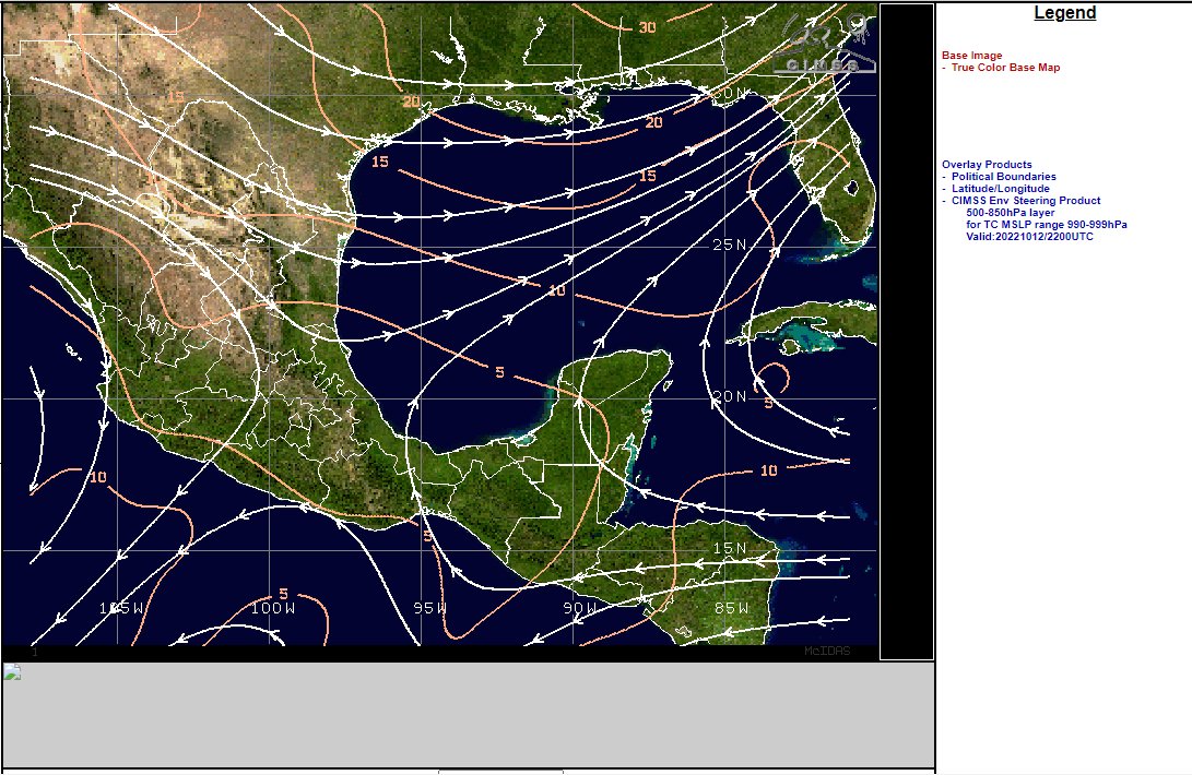
Its now pretty clear what is going on. #HurricaneKarl#TSKarl is caught in an atmospheric river generated by #TD99E (in a similar way to how #HurricaneIan was) and headed towards florida - not Mexico.
The second overlay is a special "steering" product that allows you to see where a cyclone is headed - it focusses on the 500-850hpa wind range (1.5 to 5.5kms high winds ) which are particularly important for pushing cyclones.
And as you can see #HurricaneKarl is being steered towards northern Florida at present.
This IR satelllite image [src: @TropicalTidbits] shows #TSKarl is unquestionably now #HurricaneKarl. It also shows it is not moving towards the Mexico coast line as per the current @NHC_Atlantic forecast - but moving NE. And the transformation into this was 3 hours ago.
These storms which are forming over Cuba and Haiti are 1200 to 2000kms away from #KARL but it is clear that the cause is #TSKarl, which still has not been designated as a hurricane even though its convection field now covers 454,000 kms.