#ClimateChangeNOW late summer update THREAD.
As winter in the north approaches we are roughly halfway to solstice/midwinter. The Sun's angle to the earth is moving south and we are seeing a burst of late cyclone activity in the Atlantic, Pacific and Indian oceans.
As winter in the north approaches we are roughly halfway to solstice/midwinter. The Sun's angle to the earth is moving south and we are seeing a burst of late cyclone activity in the Atlantic, Pacific and Indian oceans.
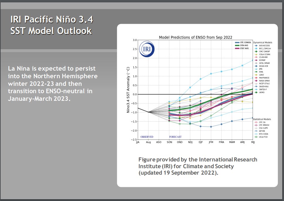
The ENSO oscilation remains in a strong La Nina position and seems likely to remain so for the forseeable future. Forecast models tend to predict a return to neutral ENSO but they have done so for some time now & the cause (Antarctic ice melt) may not go away. 


Higher air temperatures globally increase the capacity of the atmosphere to hold water and the consequence is more #ExtrremeWeather rain events causing flooding - recently in West Pacific, Central America, South America, & Indian subcontinent. (see recent 16 day forecasts below)


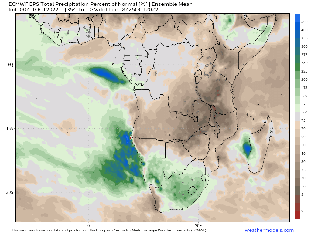
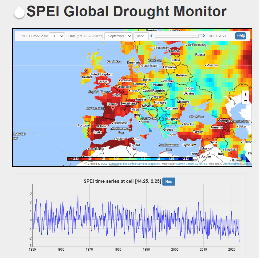
Europe's drought which has not yet broken stands out as an exception to this and at Africa's latest forecast is close to climate normal after a year of floods and persistent drought in the east.


Looking forward we can also see that the southern hemisphere will return to the front line of wrt to extreme flooding risk. However because of the far lower population the human impact will be considerably lesser.


A frozen 16-day snapshot tells us little however about the climate except to say that generally speaking at this point in time there is a lot of atmospheric water about still - and extreme weather events (esp flooding) are increasingly likely everywhere.
The remainder of this thread will (as with previous climate update threads have) consist of PWAT forecasts and satellite imagery for different parts of the world. [Earlier thread late 2021]
https://twitter.com/althecat/status/1465325786806824961?s=20&t=Wct07PZmXWgwBa5am5tCCQ
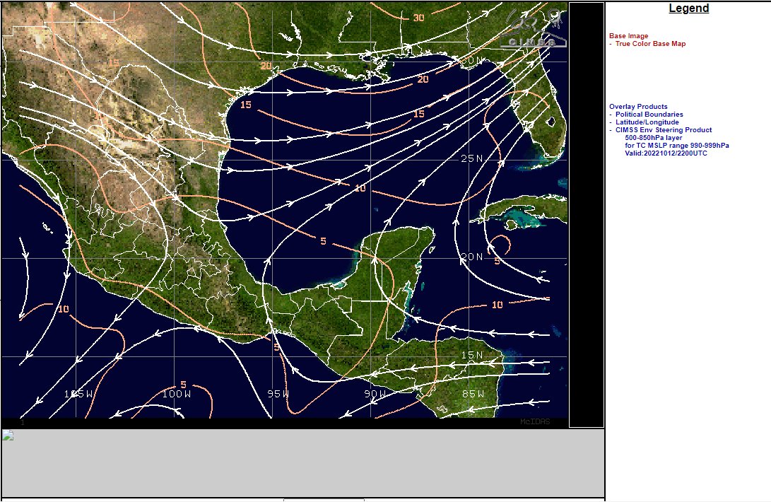
We will begin in Central America and move Westwards following the flow of atmospheric water along the equator. Central America has been experiencing multiple extreme weather events since September with Hurricanes Fiona, Ian & Julia and now #TSKarl.
https://twitter.com/althecat/status/1580120355322019840?s=20&t=Wct07PZmXWgwBa5am5tCCQ
Moving across the Pacific a dangerous situation is rapidly developing once again in the West Pacific fueled in part by the extreme convective activity over Central and the Amazon associated with #HurricaneJulia.
Four disturbance's of interest have been designated by the JTWC over the West Pacific three of which currently threaten populated areas in model forecasts.
There is a similar setup here to that in Central America with cold arctic air moving south and potentially protecting China, Japan and Korea from any risk of a landfalling cyclone. But the Phillipines, Taiwan, Southern China and Vietnam remain in the line of fire.
Here's a current satelite loop (24h) over China
Australia and NZ have both experienced significant winter flooding with abnormally high sea surface temperatures, as summer progresses the threat of even more #ExtremeWeather events caused by atmospheric rivers will be high. Here we see several such events in the forecast.
And here is the current satellite situation on the left south of Australia there is astrong atmospheric river curling around a southern - Antarctic storm - a potentially nasty combination.
Moving back up to the tropical belt, the Indian Ocean is receiving a lot of incoming atmospheric water from the current buildup in the Western Pacific.
Meanwhile the models suggest at present that this could result in a late Bay of Bengal Hurricane.
Whilst at present East Africa is relatively clear of precipitation, the moisture flowing east will impact here also in coming days.
Here we can see how the movement south of the equatorial tropical belt is increasing outflows from the Great Central African forest. The burst coming through also brings more forecast rain to East Africa including to drought stricken Somalia.
Exactly how much probably depends a lot on whether the cyclone in the Bay of Bengal eventuates - but current 10-16 day forecasts from GFS, KMA and AccessG suggest an inch or more is possible over the Coastal Horn of Africa region.


West Africa's current satellite presentation.
& southern Africa.
Eurasia - from Europe to the Pacific - Earth's largest land mass is relatively free of atmospheric water activity already.
It is also relatively free of snow cover still - except in the East.
But that is about to change.
Europe's drought [which is much milder than droughts elsewhere] has been gradually breaking from the East and as previously observed, forecast rainfall for the coming fortnight remains below climate norms. But a stormy North Atlantic may soon fix this.
We can see this in the PWAT plot and the areas most drought affected are expected to receive much of the anticipated rain in the forecast period.
What rain is forecast over the coming 16 days is expected to only produce snow in the far north - and it should go someway further in addressing the drought situation in France, Spain and southern UK.


Here's a macro view of the stormy North Atlantic the dominant feature of which is an atmospheric river being produced by the recent hurricane activity in central America.
And here is the stormy forecast over the coming fortnight.
Mercifully no more hurricane's are predicted within the forecast window.
North America is currently experiencing an unusually large arctic blast, seemingly occasioned by the expulsion by the Acrtic of some hot air that had been located over Siberia and the Northern Pacific - and this is helping suppress/elimate any threat posed by #TSKarl.
Here's a current view. As the dry air moves out over the Atlantic incoming atmospheric river activity from the Pacific is expected to produce a stormy fortnight.
Whilst snow will fall over Canada and the rockies unsually persistent high temperatures are forecast to prevent it from settling through to the end of the month.
This animation shows North America's forecast midday temperature anomaly over the next 16 days, which is what is preventing any snow from settling - it shows anomalies of 40 degrees F over Greenland and 28 degrees over the arctic sea.
And to complete the circuit of the globe, South America which has been expelling a huge amount of atmospheric water southwards as a result of the burst of convective activity related to #HurricaneJulia.
Here we can see that that the intense convection over the Amazon can be expected to continue, and increasingly its outgoing atmospheric water flows appear to be headed towards Southern Africa.
To conclude here is a full set of 16-day rainfall forecasts in roughly reverse order to the discussion.
16 Day Rainfall forecasts as at 12 October 2022
1. South America
2. Central America
3. North America
4. North Atlantic
1. South America
2. Central America
3. North America
4. North Atlantic


16 Day Rainfall forecasts as at 12 October 2022
1. Europe
2. Eurasia
3. Africa
4. India
1. Europe
2. Eurasia
3. Africa
4. India


16 Day Rainfall forecasts as at 12 October 2022
1. China
2. Japan
3. Middle East
4. Ausralia and NZ
1. China
2. Japan
3. Middle East
4. Ausralia and NZ


16 Day Rainfall forecasts as at 12 October 2022
1. West Pacific
2. North Pacific
3. East Pacific
4. South Indian Ocean
1. West Pacific
2. North Pacific
3. East Pacific
4. South Indian Ocean


• • •
Missing some Tweet in this thread? You can try to
force a refresh